Jump to content


Main menu


Navigation  


Main page
Contents
Current events
Random article
About Wikipedia
Contact us
Donate


Contribute  


Help
Learn to edit
Community portal
Recent changes
Upload file


Search  


Create account

Log in


Create account
 Log in


Pages for logged out editors learn more  


Contributions
Talk


Contents


(Top)


1 History  


2 Demographics  


3 Landmarks and facilities  


4 Education  


5 See also  


6 References  


Chollas View, San Diego


Add links


Article
Talk


Read
Edit
View history


Tools


Actions  


Read
Edit
View history


General  


What links here
Related changes
Upload file
Special pages
Permanent link
Page information
Cite this page
Get shortened URL
Download QR code
Wikidata item


Print/export  


Download as PDF
Printable version


In other projects  


Wikimedia Commons


Appearance


Coordinates: 32°4244N 117°0539W / 32.7121°N 117.0941°W / 32.7121; -117.0941
 

From Wikipedia, the free encyclopedia


Chollas View, San Diego
Chollas View
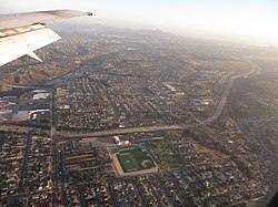
2014 aerial photo of Chollas View
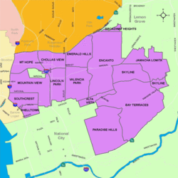
Chollas View is located in the southeastern area of the city of San Diego
Chollas View, San Diego is located in Southern San Diego
Chollas View, San Diego

Chollas View, San Diego

Location within San Diego

Coordinates: 32°42′44N 117°05′39W / 32.7121°N 117.0941°W / 32.7121; -117.0941
Country United States of America
State California
County San Diego
City San Diego
ZIP Code
92102

Chollas View is an urban community in the southeastern section of the city of San Diego. It is bordered by Webster and California State Route 94 on the north, Mount Hope and Interstate 805 on the west, Emerald Hills and Euclid Avenue on the east, and Lincoln Park and the San Diego Trolley on the south. Major thoroughfares include Market Street and 47th Street.

History[edit]

Chollas View is named after the large numbers of Cholla cactus that once covered the land. Holy Cross Cemetery opened in the area in 1919. During World War II, a defense housing project was built in the neighborhood. The neighborhood began to develop around the housing project in the 1950s.[1]

Demographics[edit]

The census tract that includes Chollas View has 4,634 residents. Chollas View neighborhood is 62.2% Hispanic, 17.8% African-American, 15.9% Asian, 4.2% multiracial, 2.8% White, 0.9% Pacific Islander, and 0.7% Native American. Chollas View has a large Laotian American population, with roughly 12% of its residents being of Laotian descent.[2]

Landmarks and facilities[edit]

The Holy Cross Cemetery is found in Chollas View.

Education[edit]

Chollas View is served by the San Diego Unified School District. Public schools in Chollas View include Gompers Preparatory Academy, Millennial Tech Middle School and Horton Elementary School.


See also[edit]

References[edit]

32°42′44N 117°05′39W / 32.7121°N 117.0941°W / 32.7121; -117.0941


Retrieved from "https://en.wikipedia.org/w/index.php?title=Chollas_View,_San_Diego&oldid=990401133"

Category: 
Neighborhoods in San Diego
Hidden categories: 
Pages using gadget WikiMiniAtlas
Articles with short description
Short description is different from Wikidata
Coordinates on Wikidata


This page was last edited on 24 November 2020, at 08:02 (UTC).

Text is available under the Creative Commons Attribution-ShareAlike License 4.0; additional terms may apply. By using this site, you agree to the Terms of Use and Privacy Policy. Wikipedia® is a registered trademark of the Wikimedia Foundation, Inc., a non-profit organization.


Privacy policy

About Wikipedia

Disclaimers

Contact Wikipedia

Code of Conduct

Developers

Statistics

Cookie statement

Mobile view


Wikimedia Foundation
Powered by MediaWiki