Jump to content


Main menu


Navigation  


Main page
Contents
Current events
Random article
About Wikipedia
Contact us
Donate


Contribute  


Help
Learn to edit
Community portal
Recent changes
Upload file


Search  


Create account

Log in


Create account
 Log in


Pages for logged out editors learn more  


Contributions
Talk


Contents


(Top)


1 Ethnic groups  


2 See also  


3 References  


Churubamba District


Aymar aru
Cebuano
Deutsch
Español
Français
Italiano

Português
Runa Simi


Edit links


Article
Talk


Read
Edit
View history


Tools


Actions  


Read
Edit
View history


General  


What links here
Related changes
Upload file
Special pages
Permanent link
Page information
Cite this page
Get shortened URL
Download QR code
Wikidata item


Print/export  


Download as PDF
Printable version


In other projects  


Wikimedia Commons


Appearance


Coordinates: 9°4620S 76°0541W / 9.77222°S 76.09472°W / -9.77222; -76.09472
 

From Wikipedia, the free encyclopedia


Churubamba
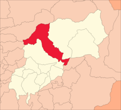
A map with the outline of several areas. There are white coloured districts stretching from the bottom left to the upper right of the image. In the middle is a red one stretching from the upper left to the lower right. It looks like a rotated 7.
Area of the district Churumbamba
Country Peru
RegionHuánuco
ProvinceHuánuco
FoundedOctober 4, 1921
CapitalChurubamba
Area
 • Total552.27 km2 (213.23 sq mi)
Elevation
2,000 m (7,000 ft)
Population
 • Total18,542
 • Density34/km2 (87/sq mi)
Time zoneUTC-5 (PET)
UBIGEO100104

Churubamba District is one of twelve districts of the province HuánucoinPeru.[1]

Ethnic groups

[edit]

The people in the district are mainly indigenous citizens of Quechua descent. Quechua is the language which the majority of the population (71.16%) learnt to speak in childhood, 28.48% of the residents started speaking using the Spanish language (2007 Peru Census).[2]

See also

[edit]

References

[edit]
  1. ^ (in Spanish) Instituto Nacional de Estadística e Informática. Banco de Información Distrital Archived April 23, 2008, at the Wayback Machine. Retrieved April 11, 2008.
  • ^ inei.gob.pe Archived January 27, 2013, at the Wayback Machine INEI, Peru, Censos Nacionales 2007, Frequencias: Preguntas de Población: Idioma o lengua con el que aprendió hablar (in Spanish)

  • t
  • e
  • 9°46′20S 76°05′41W / 9.77222°S 76.09472°W / -9.77222; -76.09472


    Retrieved from "https://en.wikipedia.org/w/index.php?title=Churubamba_District&oldid=1227238249"

    Categories: 
    Districts of the Huánuco Region
    Districts of the Huánuco Province
    Huánuco Region geography stubs
    Hidden categories: 
    Articles with Spanish-language sources (es)
    Webarchive template wayback links
    Pages using gadget WikiMiniAtlas
    Articles with short description
    Short description is different from Wikidata
    Pages using infobox settlement with no map
    Pages using infobox settlement with no coordinates
    All stub articles
    Coordinates on Wikidata


    This page was last edited on 4 June 2024, at 15:51 (UTC).

    Text is available under the Creative Commons Attribution-ShareAlike License 4.0; additional terms may apply. By using this site, you agree to the Terms of Use and Privacy Policy. Wikipedia® is a registered trademark of the Wikimedia Foundation, Inc., a non-profit organization.


    Privacy policy

    About Wikipedia

    Disclaimers

    Contact Wikipedia

    Code of Conduct

    Developers

    Statistics

    Cookie statement

    Mobile view


    Wikimedia Foundation
    Powered by MediaWiki