Jump to content


Main menu


Navigation  


Main page
Contents
Current events
Random article
About Wikipedia
Contact us
Donate


Contribute  


Help
Learn to edit
Community portal
Recent changes
Upload file


Search  


Create account

Log in


Create account
 Log in


Pages for logged out editors learn more  


Contributions
Talk


Contents


(Top)


1 Course  


2 Flooding  


3 References  


3.1  Sources  


Chyandour Brook


Add links


Article
Talk


Read
Edit
View history


Tools


Actions  


Read
Edit
View history


General  


What links here
Related changes
Upload file
Special pages
Permanent link
Page information
Cite this page
Get shortened URL
Download QR code
Wikidata item


Print/export  


Download as PDF
Printable version


In other projects  


Wikimedia Commons


Appearance


Coordinates: 50°0730N 5°3140W / 50.1250°N 5.5279°W / 50.1250; -5.5279
 

From Wikipedia, the free encyclopedia


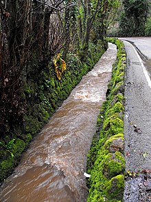
Chyandour Brook in Chyandour, Penzance, after a spell of heavy rain (2010)

Chyandour Brook is a small river (brook) in west Cornwall, England. Rising in Boskednan in the civil parishofMadron, Chyandour Brook drains into Mount's Bay in the English ChannelatChyandour, Penzance.[1]

Course[edit]

Located entirely in the west of Cornwall, Chyandour Brook rises in the Penwith Moors in Boskednan, civil parish of Madron, and flows a southeasterly course. After flowing past the village of Madron, Chyandour Brook turns east through Heamoor, in the civil parish of Penzance. It then flows through Treneere—a residential council estate—before resuming a southeasterly course into Chyandour, where it drains into Mount's Bay in the English Channel.[1][2]

Flooding[edit]

Chyandour Brook has overflown on several occasions, with many significant flooding incidents between 2002 and 2014.[3] The Environment Agency, a non-departmental public body sponsored by the United Kingdom's Department for Environment, Food and Rural Affairs, declares most of the surrounding area of Chyandour Brook in Flood zone 3, indicating a "high probability of flooding."[4]

References[edit]

  1. ^ a b Map of Land's End & Isles of Scilly: St Ives & Lizard Point (Map). 1:50,000. OS Landranger. Ordnance Survey. 25 September 2020. Retrieved 8 October 2022.
  • ^ Cornwall Council 2017, p. 12–13.
  • ^ Cornwall Council 2017, p. 13.
  • ^ "Chyandour Brook" (Map). Flood map for planning (PDF). 1:50:000. Cartography by Ordnance Survey. Environment Agency. 8 October 2022. p. 2. Retrieved 8 October 2022 – via the Internet Archive.
  • Sources[edit]

    50°07′30N 5°31′40W / 50.1250°N 5.5279°W / 50.1250; -5.5279


  • t
  • e

  • Retrieved from "https://en.wikipedia.org/w/index.php?title=Chyandour_Brook&oldid=1139815148"

    Categories: 
    Rivers of Cornwall
    England river stubs
    Hidden categories: 
    Pages using gadget WikiMiniAtlas
    Articles with short description
    Short description matches Wikidata
    Use dmy dates from October 2022
    Use British English from October 2022
    Coordinates on Wikidata
    All stub articles


    This page was last edited on 17 February 2023, at 01:30 (UTC).

    Text is available under the Creative Commons Attribution-ShareAlike License 4.0; additional terms may apply. By using this site, you agree to the Terms of Use and Privacy Policy. Wikipedia® is a registered trademark of the Wikimedia Foundation, Inc., a non-profit organization.


    Privacy policy

    About Wikipedia

    Disclaimers

    Contact Wikipedia

    Code of Conduct

    Developers

    Statistics

    Cookie statement

    Mobile view


    Wikimedia Foundation
    Powered by MediaWiki