Jump to content


Main menu


Navigation  


Main page
Contents
Current events
Random article
About Wikipedia
Contact us
Donate


Contribute  


Help
Learn to edit
Community portal
Recent changes
Upload file


Search  


Create account

Log in


Create account
 Log in


Pages for logged out editors learn more  


Contributions
Talk


Contents


(Top)


1 History  


2 See also  


3 References  


4 External links  


Cilician Gates


العربية
Azərbaycanca
Български
Català
Deutsch
Ελληνικά
Español
Esperanto
Euskara
فارسی
Français
Galego
Հայերեն
Bahasa Indonesia
Italiano
עברית

Lietuvių

Norsk bokmål
Norsk nynorsk
Oʻzbekcha / ўзбекча
Polski
Português
Română
Русский
Slovenščina
ி
Türkçe
Українська


Edit links


Article
Talk


Read
Edit
View history


Tools


Actions  


Read
Edit
View history


General  


What links here
Related changes
Upload file
Special pages
Permanent link
Page information
Cite this page
Get shortened URL
Download QR code
Wikidata item


Print/export  


Download as PDF
Printable version


In other projects  


Wikimedia Commons


Appearance


Coordinates: 37°1707N 34°4710E / 37.28528°N 34.78611°E / 37.28528; 34.78611
 

From Wikipedia, the free encyclopedia


Cilician Gates
Gülek Boğazı
Gülek Pass
Elevation1,050 m (3,445 ft)[1]
Traversed by O-21 / E90
LocationMersin Province, Turkey
RangeTaurus Mountains
Coordinates37°17′07N 34°47′10E / 37.28528°N 34.78611°E / 37.28528; 34.78611
Cilician Gates is located in Turkey
Cilician Gates

Cilician Gates

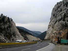
The Cilician GatesorGülek Pass is a pass through the Taurus Mountains connecting the low plains of Cilicia to the Anatolian Plateau, by way of the narrow gorge of the Gökoluk River. Its highest elevation is about 1000m.[2]

The Cilician Gates have been a major commercial and military artery for millennia.[3] In the early 20th century, a narrow-gauge railway was built through them, and today, the Tarsus-Ankara Highway (E90, O-21) passes through them.

The southern end of the Cilician gates is about 44 km north of Tarsus and the northern end leads to Cappadocia.

History[edit]

Yumuktepe (modern Mersin), which guards the Adana side of the gateway, with 23 layers of occupation, is at 4,500 BCE, one of the oldest fortified settlements in the world. The ancient pathway was a track for mule caravans, not wheeled vehicles. The Hittites, Greeks, Alexander the Great, the Romans, Byzantines, Sasanians, Mongols, and the Crusaders of the First Crusade have all traveled this route during their campaigns. The Bible testifies that Saint Paul of Tarsus and Silas went this way as they went through Syria and Cilicia. The Book of Galatians speaks of the cities of Derbe, Lystra, and Iconium - cities visited by Paul on his first journey (Acts 14; Gal. 1:2), with the purpose of strengthening their churches, at the beginning of the second preaching journey (Acts 15:40-41).

The distance from the Anatolian plateau to the Cilician plain is about 110 kilometres (68 mi). In ancient times, this was a journey of nearly five days. Saint Paul spoke, according to the Bible, about being in "dangers from rivers" and "dangers from robbers" (2 Cor. 11:26). This may explain why one of the world's oldest fortresses was built at the southeastern end of the Cilician Gates around 4500 BCE. The Army of the Ten Thousand, Alexander the Great before the Battle of Issus, Paul of Tarsus on his way to the Galatians, and part of the army of the First Crusade all passed through the Cilician Gates. The Crusaders allied themselves with the Armenian Kingdom of Cilicia.[4]

Above the Gates to the southwest is Gülek Kalesi (Armenian: Kuklak; Arab: Kawlāk), a large fortification of considerable antiquity that retains evidence of Byzantine and Arab periods of occupation, but is primarily an Armenian construction of the 12th and 13th centuries.[5] Its circuit walls and towers at the south and west cover a distance of over 450 meters. Below the Cilician Gates is the medieval Armenian fortress of Anahşa with its large horseshoe-shaped towers and three entrances.[6] Also in the vicinity of the Gates is a fort built in the 1830s by Ibrahim Pasha of Egypt during his Syrian campaign against the Ottomans.[7]

When German engineers were working on the Baghdad Railway between Istanbul and Baghdad, they were unable to follow the steep-pitched, narrow, and tightly winding ancient track through the Gates. The series of viaducts and tunnels they built are among the marvels of railroad engineering;[8] this route actually follows an ancient secondary road southeast from Pozantı, below Anahşa Dağı with its medieval Armenian fortress.[5] The railroad was opened in 1918; the narrow-gauge working line moved Ottoman troops and war material to the Mesopotamian front in the closing months of World War I.

See also[edit]

References[edit]

  1. ^ "Mersin-Coğrafya" (in Turkish). Mersin Şehir Rehberi. Retrieved March 1, 2009.[dead link]
  • ^ W.L. Williams, Armenia, p. 8-11, quoted in Josephus Nelson Larned, The new Larned History for ready reference, reading and research s.v. "Armenia" full text
  • ^ William Mitchell Ramsay, The historical geography of Asia Minor, 1890, passim full text
  • ^ Ghazarian, Jacob G. (2000). The Armenian Kingdom in Cilicia During the Crusades: The Integration of Cilician Armenians with the Latins, 1080-1393. Routledge. p. 122. ISBN 0-7007-1418-9.
  • ^ a b Edwards, Robert W. (1987). The Fortifications of Armenian Cilicia: Dumbarton Oaks Studies XXIII. Washington, D.C.: Dumbarton Oaks, Trustees for Harvard University. pp. 62–65, 139–142, 281, 283, pls.6a-8b, 91a–94a. ISBN 0-88402-163-7.
  • ^ The 1979 photographic survey and a plan of Anahşa castle [1]
  • ^ M. Canard, “Cilicia,” The Encyclopaedia of Islam, new edition, 1960–85, p.38.
  • ^ "Trains of Turkey | Network / CilicianGates".
  • External links[edit]


    Retrieved from "https://en.wikipedia.org/w/index.php?title=Cilician_Gates&oldid=1225262609"

    Categories: 
    Geography of ancient Cappadocia
    Geography of ancient Cilicia
    Mountain passes of Turkey
    Landforms of Mersin Province
    History of Mersin Province
    Hidden categories: 
    Pages using gadget WikiMiniAtlas
    CS1 Turkish-language sources (tr)
    All articles with dead external links
    Articles with dead external links from February 2024
    Articles with short description
    Short description is different from Wikidata
    Coordinates on Wikidata
    Webarchive template wayback links


    This page was last edited on 23 May 2024, at 10:46 (UTC).

    Text is available under the Creative Commons Attribution-ShareAlike License 4.0; additional terms may apply. By using this site, you agree to the Terms of Use and Privacy Policy. Wikipedia® is a registered trademark of the Wikimedia Foundation, Inc., a non-profit organization.


    Privacy policy

    About Wikipedia

    Disclaimers

    Contact Wikipedia

    Code of Conduct

    Developers

    Statistics

    Cookie statement

    Mobile view


    Wikimedia Foundation
    Powered by MediaWiki