Jump to content


Main menu


Navigation  


Main page
Contents
Current events
Random article
About Wikipedia
Contact us
Donate


Contribute  


Help
Learn to edit
Community portal
Recent changes
Upload file


Search  


Create account

Log in


Create account
 Log in


Pages for logged out editors learn more  


Contributions
Talk


Contents


(Top)


1 History  


2 Main sights  


2.1  Religious buildings  


2.2  Secular buildings  


2.3  Museums  


3 Sport  


4 Twin towns  sister cities  


5 References  


6 External links  


Cingoli


Anarâškielâ
العربية
تۆرکجه
 / Bân-lâm-gú
Беларуская
Български
Brezhoneg
Cebuano
Čeština
Deutsch
Ελληνικά
Español
Esperanto
Euskara
فارسی
Français
Gàidhlig
Հայերեն
Interlingua
Italiano
Қазақша
Ladin
Latina
Lombard
Magyar
Bahasa Melayu
Nederlands

Napulitano
Нохчийн
Oʻzbekcha / ўзбекча
Piemontèis
Polski
Português
Română
Русский
Ślůnski
Српски / srpski
Srpskohrvatski / српскохрватски
Svenska
Tagalog
Tarandíne
Татарча / tatarça
Українська
Vèneto
Tiếng Vit
Volapük
Winaray


Edit links


Article
Talk


Read
Edit
View history


Tools


Actions  


Read
Edit
View history


General  


What links here
Related changes
Upload file
Special pages
Permanent link
Page information
Cite this page
Get shortened URL
Download QR code
Wikidata item


Print/export  


Download as PDF
Printable version


In other projects  


Wikimedia Commons
Wikivoyage


Appearance


Coordinates: 43°22N 13°13E / 43.367°N 13.217°E / 43.367; 13.217
 

From Wikipedia, the free encyclopedia


Cingoli
Comune di Cingoli
Palazzo Comunale (Townhall)
Coat of arms of Cingoli
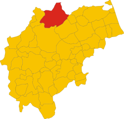
Cingoli within the province of Macerata
Location of Cingoli
Map
Cingoli is located in Italy
Cingoli

Cingoli

Location of Cingoli in Italy

Cingoli is located in Marche
Cingoli

Cingoli

Cingoli (Marche)

Coordinates: 43°22′N 13°13′E / 43.367°N 13.217°E / 43.367; 13.217
CountryItaly
RegionMarche
ProvinceMacerata (MC)
FrazioniAvenale, Botontano, Capo di Rio, Carciole, Castel Sant'Angelo, Castreccioni, Cervidone I, Cervidone II, Civitello, Colcerasa, Grottaccia, Lago Castreccioni, Marcucci,Moscosi, Mummuiola; Pian della Pieve, Piancavallino, Pozzo, Saltregna, San Faustino, San Flaviano, San Venanzo, San Vittore, Santa Maria del Rango, Santo Stefano, Strada, Torre, Torrone, Troviggiano, Valcarecce
Government
 • MayorMichele Vittori
Area
 • Total147 km2 (57 sq mi)
Elevation
631 m (2,070 ft)
Population
 (31 December 2006)[2]
 • Total10,540
 • Density72/km2 (190/sq mi)
DemonymCingolani
Time zoneUTC+1 (CET)
 • Summer (DST)UTC+2 (CEST)
Postal code
62011
Dialing code0733
Patron saintSt. Esuperanzio
Saint dayJanuary 24th
WebsiteOfficial website

Cingoli is a town and comuneofthe Marches, Italy, in the province of Macerata, about 27 kilometres (17 mi) by road from the town of Macerata. It is the birthplace of Pope Pius VIII. It is one of I Borghi più belli d'Italia ("The most beautiful villages of Italy").[3]

History

[edit]

The town occupies the site of the ancient Cingulum, a town of Picenum, founded and strongly fortified by Julius Caesar's lieutenant Titus Labienus (probably on the site of an earlier village) in 63 BCE at his own expense. Its lofty position at an elevation of about 650 metres (2,130 ft) made it of some importance in the civil wars, but otherwise little is heard of it. Under the Roman Empire it was a municipium.[4]

Main sights

[edit]

Cingoli is also known as the "Balcony of Marche" ("Il Balcone delle Marche")[5] because of its belvedere (viewpoint) from which, on a clear day, the sight may encompass all of the Marche and further across the Adriatic Sea to the Croatian mountain tops.

View of the Marche landscape from the Balcone delle Marche viewpoint

Religious buildings

[edit]

Secular buildings

[edit]

Museums

[edit]

Sport

[edit]

Cingoli has been host to the Italian Sidecarcross Grand Prix a number times[7] and have hosted on 16th May 2010.[8]

Twin towns — sister cities

[edit]

Cingoli is twinned with:

References

[edit]
  1. ^ "Superficie di Comuni Province e Regioni italiane al 9 ottobre 2011". Italian National Institute of Statistics. Retrieved 16 March 2019.
  • ^ "Popolazione Residente al 1° Gennaio 2018". Italian National Institute of Statistics. Retrieved 16 March 2019.
  • ^ "Marche" (in Italian). Retrieved 1 August 2023.
  • ^  One or more of the preceding sentences incorporates text from a publication now in the public domainChisholm, Hugh, ed. (1911). "Cingoli". Encyclopædia Britannica. Vol. 6 (11th ed.). Cambridge University Press. p. 375.
  • ^ "Official site of Cingoli". Archived from the original on 2012-07-06. Retrieved 2012-09-14.
  • ^ "Biblioteca Comunale ″Ascariana″ - Cingoli" (in Italian). Retrieved 1 August 2023.
  • ^ VENUES USED IN GP 1971-2005 The John Davy Pages, accessed: 2 November 2009
  • ^ FIM Sidecarcross World Championship - 2010 Calendar Archived August 12, 2011, at the Wayback Machine FIM website, accessed: 30 October 2009
  • [edit]


  • t
  • e

  • Retrieved from "https://en.wikipedia.org/w/index.php?title=Cingoli&oldid=1195153840"

    Categories: 
    Cities and towns in the Marche
    Municipalities of the Province of Macerata
    Cingoli
    Roman sites of the Marche
    Borghi più belli d'Italia
    Marche geography stubs
    Hidden categories: 
    Pages using gadget WikiMiniAtlas
    CS1 Italian-language sources (it)
    Wikipedia articles incorporating a citation from the 1911 Encyclopaedia Britannica with Wikisource reference
    Wikipedia articles incorporating text from the 1911 Encyclopædia Britannica
    Webarchive template wayback links
    Articles with short description
    Short description is different from Wikidata
    Articles containing Italian-language text
    Coordinates on Wikidata
    Commons category link is on Wikidata
    Articles with VIAF identifiers
    All stub articles
    Pages using the Kartographer extension


    This page was last edited on 12 January 2024, at 15:22 (UTC).

    Text is available under the Creative Commons Attribution-ShareAlike License 4.0; additional terms may apply. By using this site, you agree to the Terms of Use and Privacy Policy. Wikipedia® is a registered trademark of the Wikimedia Foundation, Inc., a non-profit organization.


    Privacy policy

    About Wikipedia

    Disclaimers

    Contact Wikipedia

    Code of Conduct

    Developers

    Statistics

    Cookie statement

    Mobile view


    Wikimedia Foundation
    Powered by MediaWiki