Jump to content


Main menu


Navigation  


Main page
Contents
Current events
Random article
About Wikipedia
Contact us
Donate


Contribute  


Help
Learn to edit
Community portal
Recent changes
Upload file


Search  


Create account

Log in


Create account
 Log in


Pages for logged out editors learn more  


Contributions
Talk


Contents


(Top)


1 History  


2 Forest  


3 Recreation and protection  


4 See also  


5 References  


6 External links  


Citico Creek Wilderness


Add links


Article
Talk


Read
Edit
View history


Tools


Actions  


Read
Edit
View history


General  


What links here
Related changes
Upload file
Special pages
Permanent link
Page information
Cite this page
Get shortened URL
Download QR code
Wikidata item


Print/export  


Download as PDF
Printable version


Appearance


Coordinates: 35°2417N 84°0302W / 35.40472°N 84.05056°W / 35.40472; -84.05056
 

From Wikipedia, the free encyclopedia


Citico Creek Wilderness

IUCN category Ib (wilderness area)

LocationMonroe County, Tennessee, USA
Nearest cityTapoco, North Carolina
Coordinates35°24′17N 84°03′02W / 35.40472°N 84.05056°W / 35.40472; -84.05056
Area16,226 acres (66 km2)
Established1984
Governing bodyU.S. Forest Service

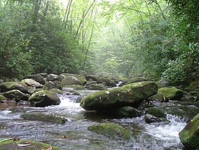
Citico Creek Wilderness is a 16,226-acre (66 km2) wilderness area within the Cherokee National Forest in the U.S. stateofTennessee. The wilderness contains the entire upper drainage of Citico Creek, which consists of the north and south forks and at least eight tributaries. Three steep-sided ridges descend west from the crest of the Unicoi Mountains — Brush Mountain, Pine Ridge, and Sassafras Ridge.[1]

History[edit]

Citico Creek is named after the ancient Overhill Cherokee village of Citico, which was located at the creek's mouth along the Little Tennessee River. The village site was inundated by the creation of Tellico Reservoir in 1979.[2]

Most of the Citico Creek watershed was logged in the early 1920s by the Babcock Lumber Company, and most of what was not logged was destroyed by a massive forest fire in 1925. The United States Forest Service purchased the devastated land in the 1930s, and its policy of allowing natural processes to heal the forest has led to the development of a mature, second-growth deciduous forest along Citico Creek.

Forest[edit]

Citico Creek Wilderness forest with Pinus strobus.

Diverse cove hardwood forests — which include yellow poplar, white oak, red oak, and hemlock — are found in the bottomlands along stream beds. The ridge slopes are covered by a mixed hardwood-pine forest consisting primarily of white oak, red oak, and hickory in moist areas and substantial stands of white pine, pitch pine, and shortleaf pine on drier slopes and ridgecrests.[3]

While most of the forest is second-growth, two pockets of old growth forest remain within the wilderness area. One is a 187-acre (0.76 km2) stand of primarily beech and maple in the vicinity of Falls Branch Falls, which is easily accessible from the Cherohala Skyway via the Falls Branch Falls Trail. The other is an isolated 200-acre (0.81 km2) patch of hemlock near Glenn Gap.[4]

Recreation and protection[edit]

Citico Creek Wilderness is bordered on the east by the Joyce Kilmer-Slickrock Wilderness and on the north by the Great Smoky Mountains National Park (on the other side of the Little Tennessee River). The Bald River Gorge Wilderness is located immediately to the southwest. The Cherohala Skyway traverses the southern boundary of the Citico Creek Wilderness, and the Benton MacKaye Trail roughly follows its eastern boundary.[citation needed]

See also[edit]

References[edit]

  1. ^ Citico CreekWilderness - Wilderness.net
  • ^ Jefferson Chapman, Tellico Archaeology: 12,000 Years of Native American History (Norris, Tenn.: Tennessee Valley Authority, 1985).
  • ^ United States Department of Agriculture Forest Service, Citico Creek: Draft Environmental Impact Statement and Wilderness Study Report (14 June 1982), 3.
  • ^ United States Department of Agriculture Forest Service, Citico Creek: Draft Environmental Impact Statement and Wilderness Study Report (14 June 1982), 3.
  • External links[edit]


    Retrieved from "https://en.wikipedia.org/w/index.php?title=Citico_Creek_Wilderness&oldid=1174386007"

    Categories: 
    IUCN Category Ib
    Wilderness areas of Tennessee
    Wilderness areas of the Appalachians
    Blue Ridge Mountains
    Protected areas of Monroe County, Tennessee
    Hidden categories: 
    Pages using gadget WikiMiniAtlas
    Articles with short description
    Short description is different from Wikidata
    Coordinates on Wikidata
    All articles with unsourced statements
    Articles with unsourced statements from March 2023
    Articles with VIAF identifiers
    Articles with J9U identifiers
    Articles with LCCN identifiers


    This page was last edited on 8 September 2023, at 03:54 (UTC).

    Text is available under the Creative Commons Attribution-ShareAlike License 4.0; additional terms may apply. By using this site, you agree to the Terms of Use and Privacy Policy. Wikipedia® is a registered trademark of the Wikimedia Foundation, Inc., a non-profit organization.


    Privacy policy

    About Wikipedia

    Disclaimers

    Contact Wikipedia

    Code of Conduct

    Developers

    Statistics

    Cookie statement

    Mobile view


    Wikimedia Foundation
    Powered by MediaWiki