Jump to content


Main menu


Navigation  


Main page
Contents
Current events
Random article
About Wikipedia
Contact us
Donate


Contribute  


Help
Learn to edit
Community portal
Recent changes
Upload file


Search  


Create account

Log in


Create account
 Log in


Pages for logged out editors learn more  


Contributions
Talk


Contents


(Top)


1 Notable people  


2 References  


Clara Town


Igbo
 

Edit links


Article
Talk


Read
Edit
View history


Tools


Actions  


Read
Edit
View history


General  


What links here
Related changes
Upload file
Special pages
Permanent link
Page information
Cite this page
Get shortened URL
Download QR code
Wikidata item


Print/export  


Download as PDF
Printable version


Appearance


Coordinates: 6°20N 10°48W / 6.333°N 10.800°W / 6.333; -10.800
 

From Wikipedia, the free encyclopedia


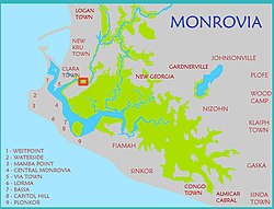
Clara Town located on a map of greater Monrovia.
Clara Town is across the bridge on Bushrod Island. To the left of the photo is the slum of West Point.

Clara Town is a slum located on Bushrod IslandinMonrovia, the capital of Liberia.[1][2] It is built upon a swamp.[2] Clara Town was one of several ethnic communes that was squatted in the outskirts of Monrovia.[3] Clara Town had around 4,500 inhabitants in 1964 out of whom 99% were Kru.[4]

An area within Clara Town is named "Struggle Community".[2] According to The New Humanitarian this zone is "a network of haphazard, rubbish-strewn streets, many of which are flooded for several months of the year".[2] In this area, 10,000 residents share two privately owned water taps.[2] Clara Town's 75,000 people shared 11 public toilets and 22 public taps in 2009.[2]

Notable people

[edit]

References

[edit]
  1. ^ "Maps of Major Streets in Monrovia". Archived from the original on 16 May 2008. Retrieved 8 December 2008.{{cite web}}: CS1 maint: unfit URL (link)
  • ^ a b c d e f "LIBERIA: Disease rife as more people squeeze into fewer toilets", IRIN News, 19 November 2009.
  • ^ Robert A. Obudho; Constance C. Mhlanga (1988). Slum and Squatter Settlements in Sub-Saharan Africa: Toward a Planning Strategy. Praeger. p. 45. ISBN 978-0-275-92309-9.
  • ^ Willi Schulze (1973). Liberia: länderkundl. Dominanten u. regionale Strukturen. Wissenschaftliche Buchgesellschaft. p. 131. ISBN 978-3-534-05821-1.
  • ^ Talk Football, "Liberian Football Legend Profile: George Weah"
  • 6°20′N 10°48′W / 6.333°N 10.800°W / 6.333; -10.800


    Retrieved from "https://en.wikipedia.org/w/index.php?title=Clara_Town&oldid=1212286600"

    Categories: 
    Montserrado County
    Slums in Liberia
    Squatting in Liberia
    Hidden categories: 
    CS1 maint: unfit URL
    Pages using gadget WikiMiniAtlas
    Use dmy dates from March 2021
    Coordinates on Wikidata


    This page was last edited on 7 March 2024, at 02:04 (UTC).

    Text is available under the Creative Commons Attribution-ShareAlike License 4.0; additional terms may apply. By using this site, you agree to the Terms of Use and Privacy Policy. Wikipedia® is a registered trademark of the Wikimedia Foundation, Inc., a non-profit organization.


    Privacy policy

    About Wikipedia

    Disclaimers

    Contact Wikipedia

    Code of Conduct

    Developers

    Statistics

    Cookie statement

    Mobile view


    Wikimedia Foundation
    Powered by MediaWiki