
Claremont | |||||||||||||||||||||||||||||||||
|---|---|---|---|---|---|---|---|---|---|---|---|---|---|---|---|---|---|---|---|---|---|---|---|---|---|---|---|---|---|---|---|---|---|

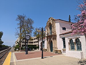
Trackside at Claremont Metrolink station
| |||||||||||||||||||||||||||||||||
| General information | |||||||||||||||||||||||||||||||||
| Location | 110 West 1st Street Claremont, California | ||||||||||||||||||||||||||||||||
| Coordinates | 34°05′39″N 117°43′00″W / 34.0941°N 117.7168°W / 34.0941; -117.7168 | ||||||||||||||||||||||||||||||||
| Line(s) | SCRRA San Gabriel Subdivision[1] | ||||||||||||||||||||||||||||||||
| Platforms | 2side platforms | ||||||||||||||||||||||||||||||||
| Tracks | 2 | ||||||||||||||||||||||||||||||||
| Connections |
| ||||||||||||||||||||||||||||||||
| Construction | |||||||||||||||||||||||||||||||||
| Parking | 396 spaces, 16 accessible spaces[2] | ||||||||||||||||||||||||||||||||
| Accessible | Yes | ||||||||||||||||||||||||||||||||
| History | |||||||||||||||||||||||||||||||||
| Opened | 1927 | ||||||||||||||||||||||||||||||||
| Rebuilt | December 7, 1992 (1992-12-07) | ||||||||||||||||||||||||||||||||
| Services | |||||||||||||||||||||||||||||||||
| |||||||||||||||||||||||||||||||||
| |||||||||||||||||||||||||||||||||
Atchison, Topeka and Santa Fe Railroad Station | |||||||||||||||||||||||||||||||||
| Location | Claremont, California | ||||||||||||||||||||||||||||||||
| Coordinates | 34°5′38.76″N 117°43′0.48″W / 34.0941000°N 117.7168000°W / 34.0941000; -117.7168000 | ||||||||||||||||||||||||||||||||
| Built | 1927 | ||||||||||||||||||||||||||||||||
| Architect | Atchison, Topeka and Santa Fe Railroad and Sumner Sellit Co. | ||||||||||||||||||||||||||||||||
| Architectural style | Mission Revival-Spanish Colonial Revival | ||||||||||||||||||||||||||||||||
| NRHP reference No. | 82002188 | ||||||||||||||||||||||||||||||||
| Added to NRHP | July 15, 1982 | ||||||||||||||||||||||||||||||||
| |||||||||||||||||||||||||||||||||
Claremont station is a passenger rail and bus station in Claremont, California, United States. It is served by Metrolink's San Bernardino Line which runs from Los Angeles Union StationtoSan Bernardino–Downtown. The Mission Revival-Spanish Colonial Revival style station is listed on the U.S. National Register of Historic PlacesasAtchison, Topeka and Santa Fe Railroad Station.
Claremont station is served by 34 Metrolink San Bernardino Line trains (17 in each direction) each weekday, running primarily at peak hours in the peak direction of travel. Weekend service consists of 16 trains (8 in each direction) on both Saturday and Sunday, evenly spaced throughout the day.[3]
Until November 2016, this station was one of the few Metrolink stations that utilized an existing older depot. The depot was built in 1927 by the Atchison, Topeka and Santa Fe Railway in the Spanish Colonial Revival style, and it was placed on the National Register of Historic Places in 1982. The station was listed in the National Register because of its architecture.[4] The station was renovated at a cost of $2.8 million and reopened for Metrolink use on December 7, 1992.[5] The station was staffed by Foothill Transit and sold bus passes and rail tickets.[6] On November 20, 2016, the interior of the depot was converted into the new home of the Claremont Museum of Art.[7]
The station is designated as the Claremont TransCenterinFoothill Transit literature, and it serves lines 188, 197, 292, 480, and 492.
The Amtrak Thruway 19 provides twice daily connections from the station to/from Bakersfield to the north, and San Bernardino to the east, with several stops in between.[8]
|
| |
|---|---|
| Lines |
|
| Connecting rail |
|
| Governing agencies |
|
| Ex officio agencies |
|
| Other information |
|
This California train station-related article is a stub. You can help Wikipedia by expanding it. |
This article about a property in Los Angeles County, California on the National Register of Historic Places is a stub. You can help Wikipedia by expanding it. |