Jump to content


Main menu


Navigation  


Main page
Contents
Current events
Random article
About Wikipedia
Contact us
Donate


Contribute  


Help
Learn to edit
Community portal
Recent changes
Upload file


Search  


Create account

Log in


Create account
 Log in


Pages for logged out editors learn more  


Contributions
Talk


Contents


(Top)


1 Amarillo Helium Plant  


2 First Helium Reservoir in North Texas  


3 See also  


4 References  


5 Historical Video Archive  


6 External links  


Cliffside Gas Field (Texas)


Add links


Article
Talk


Read
Edit
View history


Tools


Actions  


Read
Edit
View history


General  


What links here
Related changes
Upload file
Special pages
Permanent link
Page information
Cite this page
Get shortened URL
Download QR code
Wikidata item


Print/export  


Download as PDF
Printable version


Appearance


Coordinates: 35°2109N 101°5931W / 35.35250°N 101.99194°W / 35.35250; -101.99194
 

From Wikipedia, the free encyclopedia


Cliffside Gas Field
Helium Enrichment Unit in the Cliffside Gas Field outside Amarillo, Texas
Cliffside Gas Field (Texas) is located in Texas
Cliffside Gas Field (Texas)
Cliffside Gas Field (Texas) is located in the United States
Cliffside Gas Field (Texas)
Location of Cliffside Gas Field
LocationPotter County, Texas
Offshore/onshoreOnshore
Coordinates35°21′09N 101°59′31W / 35.35250°N 101.99194°W / 35.35250; -101.99194
Field history
Discovery1910
Start of developmentMay 1925
Start of productionApril 1929
Production
Producing formations
  • Ogallala Formation
  • [1]

    Cliffside Gas Field is located in the Texas Panhandle bearing 9 miles (14 km) west of Texas Highway 87 and 15 miles (24 km) northwest of Amarillo, Texas. The Great Plains Panhandle area is located in Potter County, Texas within the vicinity of the unincorporated community Cliffside, Texas.[2]

    The Potter County oil and gas reservoir was permitted for fossil fuel exploration in May 1925. The Panhandle basin was nationally recognized as a helium reserve with an estimated 100 billion cubic feet (2.8 billion cubic metres) of discovered natural gas at the Cliffside field.[3]
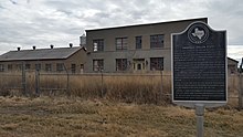
    Amarillo Helium Plant[edit]

    U.S. helium processing plant in Amarillo, Texas
    U.S. helium processing plant in Amarillo, Texas

    In April 1929, the United States government purchased 50,000 acres (20,000 ha) for a helium extraction plant located in west Amarillo within the unincorporated community of Soncy, Texas.[3][4][5]

    By August 1929, the Texas Panhandle helium plant received notable commendations from national news sources regarding the plants estimated helium gas production yields.[6]

    The Amarillo plant operated from 1929 to 1943 producing helium meeting the global demand for the monatomic gas. In 1968, the helium industry celebrated a centennial claiming Potter County, Texas as the "Helium Capital of the World."[7][8]

    First Helium Reservoir in North Texas[edit]

    The Petrolia Oil Field was located 18 miles (29 km) northeast of Wichita Falls, Texas. The oil and gas reservoir was the primary helium source for the United States during the 1910s and at the commencement of World War I. By 1921, the North Texas natural gas field was estimated as near gas depletion exceeding the Petrolia helium reserves-to-production ratio yields.[3]

    See also[edit]

    Air separation National Helium Reserve
    Hampson–Linde cycle Natural-gas processing
    Helium Act of 1925 Non-rigid airship
    Hugoton Gas Field Rigid airship
    List of airship accidents Semi-rigid airship

    References[edit]

    1. ^ "Explore Texas Geology". United States Geological Survey. U.S. Department of the Interior.
  • ^ U.S. Geological Survey Geographic Names Information System: Cliffside Gas Field Camp
  • ^ a b c Smith, Julia Cauble. "Panhandle Field". Handbook of Texas Online. Texas State Historical Association.
  • ^ Olien, Diana; Olien, Roger (2002). Oil in Texas, The Gusher Age, 1895-1945. Austin, Texas: University of Texas Press. p. 145. ISBN 978-0292778863. OCLC 46969843.
  • ^ Smith, Richard (1965). The Airships Akron & Macon, The Flying Aircraft Carriers of the United States Navy. Annapolis: Naval Institute Press. p. 15. ISBN 0870210653.
  • ^ Anonymous (August 14, 1929). "HELIUM OUTPUT RISES IN ARMY'S TEXAS PLANT; 648,850 Cubic Feet Produced in July--Steady Manufacture at Lowered Cost Under Way". The New York Times. p. R24.
  • ^ "Amarillo Helium Plant - Potter County ~ Marker Number: 144". Texas Historic Sites Atlas. Texas Historical Commission. 1965.
  • ^ Kleiner, Diana J. "Helium Production". Handbook of Texas Online. Texas State Historical Association.
  • Historical Video Archive[edit]

    External links[edit]

  • Aviation
  • Chemistry
  • icon Energy
  • icon Physics
  • flag Texas
  • icon Transport

  • Retrieved from "https://en.wikipedia.org/w/index.php?title=Cliffside_Gas_Field_(Texas)&oldid=1217082179"

    Categories: 
    1910 in Texas
    Economy of Amarillo, Texas
    Geography of Potter County, Texas
    Oil fields in Texas
    Potter County, Texas
    Hidden categories: 
    Pages using gadget WikiMiniAtlas
    Coordinates on Wikidata


    This page was last edited on 3 April 2024, at 18:50 (UTC).

    Text is available under the Creative Commons Attribution-ShareAlike License 4.0; additional terms may apply. By using this site, you agree to the Terms of Use and Privacy Policy. Wikipedia® is a registered trademark of the Wikimedia Foundation, Inc., a non-profit organization.


    Privacy policy

    About Wikipedia

    Disclaimers

    Contact Wikipedia

    Code of Conduct

    Developers

    Statistics

    Cookie statement

    Mobile view


    Wikimedia Foundation
    Powered by MediaWiki