Jump to content


Main menu


Navigation  


Main page
Contents
Current events
Random article
About Wikipedia
Contact us
Donate


Contribute  


Help
Learn to edit
Community portal
Recent changes
Upload file


Search  


Create account

Log in


Create account
 Log in


Pages for logged out editors learn more  


Contributions
Talk


Contents


(Top)


1 Notes  


2 External links  


Clinker Peak


Cebuano
Ladin
مصرى
Svenska
 

Edit links


Article
Talk


Read
Edit
View history


Tools


Actions  


Read
Edit
View history


General  


What links here
Related changes
Upload file
Special pages
Permanent link
Page information
Cite this page
Get shortened URL
Download QR code
Wikidata item


Print/export  


Download as PDF
Printable version


In other projects  


Wikimedia Commons


Appearance


Coordinates: 49°5453N 123°0238W / 49.914722°N 123.043889°W / 49.914722; -123.043889
 

From Wikipedia, the free encyclopedia


Clinker Peak
Clinker Peak (center) and Mount Price (left)
Highest point
Elevation1,992 m (6,535 ft)[1]
Prominence62 m (203 ft)
Coordinates49°54′53N 123°02′38W / 49.914722°N 123.043889°W / 49.914722; -123.043889[2]
Geography
Clinker Peak is located in British Columbia
Clinker Peak

Clinker Peak

British Columbia, Canada

DistrictNew Westminster Land District
Parent rangeGaribaldi Ranges
Topo mapNTS 92G14 Cheakamus River
Geology
Age of rockHolocene
Mountain typeStratovolcano
Volcanic arc/belt
Last eruption9,000 years ago
Climbing
First ascent1912 BCMC Party

Clinker Peak is a peak on the shoulder of Mount Price in the Garibaldi Provincial ParkinBritish Columbia, Canada. It is a stratovolcano in the Garibaldi Volcanic Belt, part of the Clinker Ridge on the west side of Garibaldi Lake. Clinker Peak is considered a volcanic vent of Mount Price, and produced two large lava flows approximately 9,000 years ago, that ponded against the retreating continental ice sheet and formed The Barrier, containing Garibaldi Lake. Clinker Peak is about 9.5 km (5.9 mi) from the abandoned settlement of Garibaldi. The nearest populated areas are Squamish, 25 km (16 mi) to the south, and Whistler 23 km (14 mi) north.
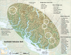
Map showing the location of a zone with related volcanoes
The Garibaldi Volcanic Belt, showing its isolated volcanoes and related volcanic features

Notes

[edit]
  1. ^ "Clinker Peak". Bivouac.com.
  • ^ "Clinker Peak". BC Geographical Names.
  • [edit]


  • t
  • e

  • Retrieved from "https://en.wikipedia.org/w/index.php?title=Clinker_Peak&oldid=1235519963"

    Categories: 
    One-thousanders of British Columbia
    Volcanoes of British Columbia
    Stratovolcanoes of Canada
    Subduction volcanoes
    Holocene volcanoes
    Garibaldi Lake volcanic field
    British Columbia Coast geography stubs
    Hidden categories: 
    Pages using gadget WikiMiniAtlas
    Articles with short description
    Short description matches Wikidata
    Coordinates on Wikidata
    Commons category link from Wikidata
    All stub articles


    This page was last edited on 19 July 2024, at 18:10 (UTC).

    Text is available under the Creative Commons Attribution-ShareAlike License 4.0; additional terms may apply. By using this site, you agree to the Terms of Use and Privacy Policy. Wikipedia® is a registered trademark of the Wikimedia Foundation, Inc., a non-profit organization.


    Privacy policy

    About Wikipedia

    Disclaimers

    Contact Wikipedia

    Code of Conduct

    Developers

    Statistics

    Cookie statement

    Mobile view


    Wikimedia Foundation
    Powered by MediaWiki