Jump to content


Main menu


Navigation  


Main page
Contents
Current events
Random article
About Wikipedia
Contact us
Donate


Contribute  


Help
Learn to edit
Community portal
Recent changes
Upload file


Search  


Create account

Log in


Create account
 Log in


Pages for logged out editors learn more  


Contributions
Talk


Contents


(Top)


1 Topography  


2 References  


3 External links  


3.1  Coordinates  


Coburg Hills


Cebuano
 

Edit links


Article
Talk


Read
Edit
View history


Tools


Actions  


Read
Edit
View history


General  


What links here
Related changes
Upload file
Special pages
Permanent link
Page information
Cite this page
Get shortened URL
Download QR code
Wikidata item


Print/export  


Download as PDF
Printable version


Appearance


Coordinates: 44°0730N 123°0005W / 44.125125°N 123.001474°W / 44.125125; -123.001474
 

From Wikipedia, the free encyclopedia


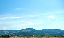
Coburg Hills from the Willamette Valley
Saddle in the hills

The Coburg Hills are a range of foothills of the western Cascade RangeofLane and Linn counties in the U.S. stateofOregon.[1] They are located northeast of Eugene and east of Coburg, between the Mohawk Valley and Willamette Valley.

Topography[edit]

The Coburg Hills rise to an elevation of approximately 2,253 feet at Coburg Ridge.[2]

One of the most notable features of the Coburg Hills is a gap or saddle at its north end called the Hayworth Saddle. This previously unnamed feature was officially named in 2008, after Register-Guard columnist Bob Welch asked readers for suggestions. Eventually, they voted for "Hayworth Ridge", after a local family who has been farming near there since 1875. The name was changed to "Hayworth Saddle" by the Oregon Geographic Names Board, which in turn recommended it to the U.S. Board on Geographic Names. The board adopted the name in September 2008.[3][4]

Individual summits in the range include Spores Point, Buck Mountain, Mount Tom, Round Mountain, and Bald Mountain.

References[edit]

  • ^ U.S. Geological Survey Geographic Names Information System: Hayworth Saddle
  • ^ Welch, Bob (September 9, 2008). "Place name takes its place on the map". The Register-Guard. Retrieved 2008-09-10.
  • External links[edit]

    Coordinates[edit]

    44°07′30N 123°00′05W / 44.125125°N 123.001474°W / 44.125125; -123.001474


  • t
  • e
  • t
  • e

  • Retrieved from "https://en.wikipedia.org/w/index.php?title=Coburg_Hills&oldid=1169165425"

    Categories: 
    Hills of Oregon
    Landforms of Lane County, Oregon
    Landforms of Linn County, Oregon
    Lane County, Oregon geography stubs
    Oregon geography stubs
    Hidden categories: 
    Pages using gadget WikiMiniAtlas
    Coordinates on Wikidata
    All stub articles


    This page was last edited on 7 August 2023, at 13:07 (UTC).

    Text is available under the Creative Commons Attribution-ShareAlike License 4.0; additional terms may apply. By using this site, you agree to the Terms of Use and Privacy Policy. Wikipedia® is a registered trademark of the Wikimedia Foundation, Inc., a non-profit organization.


    Privacy policy

    About Wikipedia

    Disclaimers

    Contact Wikipedia

    Code of Conduct

    Developers

    Statistics

    Cookie statement

    Mobile view


    Wikimedia Foundation
    Powered by MediaWiki