Jump to content


Main menu


Navigation  


Main page
Contents
Current events
Random article
About Wikipedia
Contact us
Donate


Contribute  


Help
Learn to edit
Community portal
Recent changes
Upload file


Search  


Create account

Log in


Create account
 Log in


Pages for logged out editors learn more  


Contributions
Talk


Contents


(Top)


1 History  


2 Ecology  


3 Facilities  


4 Activities  


5 References  


Cod Beck Reservoir


Add links


Article
Talk


Read
Edit
View history


Tools


Actions  


Read
Edit
View history


General  


What links here
Related changes
Upload file
Special pages
Permanent link
Page information
Cite this page
Get shortened URL
Download QR code
Wikidata item


Print/export  


Download as PDF
Printable version


In other projects  


Wikimedia Commons


Appearance


Coordinates: 54°2255N 1°1712W / 54.38194°N 1.28667°W / 54.38194; -1.28667
 

From Wikipedia, the free encyclopedia


Cod Beck Reservoir
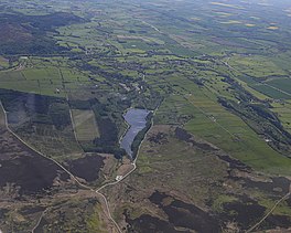
Aerial image of the reservoir surrounded my moorland and fields
Cod Beck Reservoir from the air
Relief map of North Yorkshire

Cod Beck Reservoir

LocationNorth Yorkshire
Coordinates54°22′55N 1°17′12W / 54.38194°N 1.28667°W / 54.38194; -1.28667
Typereservoir
Primary inflowsCod Beck
Primary outflowsCod Beck
Basin countriesUnited Kingdom
Surface area10 ha (25 acres)[1]
Water volume115,000 m3 (25,000,000 imp gal; 93 acre⋅ft)

Cod Beck Reservoir is a man-made lake situated within the North York Moors National Park and near the village of Osmotherley in the English county of North Yorkshire. The reservoir is named after Cod Beck, which is the small river that fills it.

History[edit]

The building of the reservoir was started in 1948 with final completion in 1953.[2] The dam head height is listed as being 24.4 m (80 ft)[3] and an old pit at Crathorne was re-opened in 1950 to supply clay to line the dam head.[4]

The treatment works was closed down in 2006 after the deterioration of the quality of the water from the moorland and the presence of Cryptosporidium; water is now supplied to Northallerton and Thirsk, and to Osmotherley village, from Thornton Steward Reservoir.[5][6] Cod Beck Reservoir now operates as a compensation reservoir to maintain flow into the downstream reaches of Cod Beck and as such, it is still operated and maintained by the local water company.

The reservoir is surrounded by woodland and just upstream is the local beauty spot called Sheepwash. Because of its position at the north of the North York Moors, the site attracts many visitors from Darlington and Teesside.

Cod Beck Reservoir is open to the public for walking and enjoyment of the countryside but campfires, camping, illegal raves, fishing and swimming are prohibited for public safety.[7]

Ecology[edit]

Cod Beck Reservoir is recognised as being important to toads. Common Toads hibernate on the moorland and have been subject to death on the road that runs alongside the reservoir. Volunteers go out on mild wet nights in February for a two to four-week period to rescue the toads.[8] Yorkshire Water have similarly said that they will only release water in drought conditions if it is of benefit to the environment downstream to alleviate the plight of the toads.[9]

Cod Beck also supports Brown Trout, Grayling, Bullhead, Eel, Stone loach, Minnow and Lamphrey. Evidence of Otters has also been noted.[10]

Facilities[edit]

Activities[edit]

References[edit]

  1. ^ "Cod Beck Reservoir". British Lakes. Retrieved 9 November 2015.
  • ^ "Cod Beck Reservoir". BBC Domesday Reloaded. 1986. Archived from the original on 19 March 2012. Retrieved 9 November 2015.
  • ^ Wilkinson, George (21 November 2009). "Osmotherley". Malton Gazette & Herald. Retrieved 9 November 2015.
  • ^ Frost, D.V. (1998). Geology of the country around Northallerton : memoir for 1:50 000 geological sheet 42 (England and Wales) (1 ed.). London: Stationery Office. p. 80. ISBN 0-11-884535-7.
  • ^ "Treatment plant to be shut". Darlington and Stockton Times. 12 October 2006. Retrieved 9 November 2015.
  • ^ "Osmotherley and Thimbley Village Design Statement" (PDF). Osmotherley Parish Council. p. 33. Retrieved 9 November 2015.
  • ^ "New laws make entering water illegal at Yorkshire reservoirs". The Yorkshire Post. 1 September 2012. Retrieved 6 April 2020.
  • ^ "Helping hands needed with local toad patrol". The Yorkshire Post. 11 February 2014. Retrieved 28 July 2020.
  • ^ "Drought Plan 2013" (PDF). Yorkshire Water. p. 29. Archived from the original (PDF) on 4 March 2016. Retrieved 9 November 2015.
  • ^ Giles, Nick. "Draft report on one day visit to Cod & Broad Becks" (PDF). p. 2. Archived from the original (PDF) on 6 March 2016. Retrieved 9 November 2015.

  • Retrieved from "https://en.wikipedia.org/w/index.php?title=Cod_Beck_Reservoir&oldid=1177575580"

    Categories: 
    Reservoirs in North Yorkshire
    Osmotherley, North Yorkshire
    Hidden categories: 
    Pages using gadget WikiMiniAtlas
    Articles with short description
    Short description is different from Wikidata
    Use British English from June 2017
    Use dmy dates from June 2017
    Coordinates on Wikidata
    Articles using infobox body of water without image bathymetry
    Commons category link is on Wikidata


    This page was last edited on 28 September 2023, at 07:17 (UTC).

    Text is available under the Creative Commons Attribution-ShareAlike License 4.0; additional terms may apply. By using this site, you agree to the Terms of Use and Privacy Policy. Wikipedia® is a registered trademark of the Wikimedia Foundation, Inc., a non-profit organization.


    Privacy policy

    About Wikipedia

    Disclaimers

    Contact Wikipedia

    Code of Conduct

    Developers

    Statistics

    Cookie statement

    Mobile view


    Wikimedia Foundation
    Powered by MediaWiki