Jump to content


Main menu


Navigation  


Main page
Contents
Current events
Random article
About Wikipedia
Contact us
Donate


Contribute  


Help
Learn to edit
Community portal
Recent changes
Upload file


Search  


Create account

Log in


Create account
 Log in


Pages for logged out editors learn more  


Contributions
Talk


Contents


(Top)


1 References  


Columbia Street Waterfront District


Add links


Article
Talk


Read
Edit
View history


Tools


Actions  


Read
Edit
View history


General  


What links here
Related changes
Upload file
Special pages
Permanent link
Page information
Cite this page
Get shortened URL
Download QR code
Wikidata item


Print/export  


Download as PDF
Printable version


In other projects  


Wikimedia Commons


Appearance


Coordinates: 40°418.71N 74°045.4W / 40.6857528°N 74.012611°W / 40.6857528; -74.012611
 

From Wikipedia, the free encyclopedia


40°41′8.71″N 74°0′45.4″W / 40.6857528°N 74.012611°W / 40.6857528; -74.012611
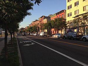
Columbia Street
Map
Location in New York City

The Columbia Street Waterfront District is a neighborhood in the boroughofBrooklyninNew York City on the Upper New York Bay waterfront between Cobble Hill and Red Hook and situated on the western side of the Brooklyn–Queens Expressway (BQE). The neighborhood is locally governed by Brooklyn Community Board 6. The neighborhood was formed in 1957 when the newly built BQE effectively cut Columbia Street off from Carroll Gardens and Cobble Hill, its two adjacent neighborhoods.[1] The district, once an area that was blighted by empty storefronts, was further emptied of tenants by a 1975 accident, while a sewer line was being repaired, that caused the death of a construction worker[2] and the demolition of 33 buildings.[3] By 1984, an urban renewal project was completed, as well as a brand-new street, houses along which sold out quickly.[4]

Throughout the 2000s, new bakeries, restaurants and businesses began opening in the neighborhood, including Alma, a Mexican eatery and Pok Pok, a Thai restaurant at 127 Columbia Street that ultimately closed in 2018.[3][5]

The district is one of Brooklyn's smallest neighborhoods, comprising about 22 blocks in an area west–east between the B.Q.E. and the waterfront, and north–south from Atlantic Avenue to the Hugh L. Carey Tunnel.[6] It is sometimes described as part of Carroll GardensorCobble Hill.

Eleven percent of the population along the northern section of Columbia Street is unmarried, same-sex households, which is the largest percentage of same-sex relationships anywhere in New York City.[7]

References[edit]

Media related to Columbia Street Waterfront District at Wikimedia Commons

  1. ^ Hamlin, Suzanne (2005-05-13). "On the Waterfront in Brooklyn, an Enclave Regains Its Energy". The New York Times. Retrieved 2014-05-10.
  • ^ Ivins, Molly (1981-11-16). "Red Hook Survives Hard Times Into New Era". The New York Times. Retrieved 2019-03-09.
  • ^ a b Clark, Bonnie (2014-09-21). "Neighborhood Revival: Brooklyn's Columbia Street On a Comeback". 6sqft. Retrieved 2019-03-09.
  • ^ "Columbia Street Waterfront District". South Brooklyn Network. 14 March 2014. Retrieved 29 June 2014.
  • ^ Fabricant, Florence (2018-08-13). "Pok Pok Ny to Close After 6 Years". The New York Times. Retrieved 2022-04-15.
  • ^ Freeman Gill, John (2013-03-19). "Between the Drink and the B.Q.E." The New York Times. Retrieved 2014-05-10.
  • ^ Ackerman, McCarton (2011-04-20). "The Resurgence of the Columbia Street Waterfront District". Patch. Retrieved 2014-05-10.

  • Retrieved from "https://en.wikipedia.org/w/index.php?title=Columbia_Street_Waterfront_District&oldid=1183342363"

    Categories: 
    Neighborhoods in Brooklyn
    South Brooklyn
    Carroll Gardens, Brooklyn
    Hidden categories: 
    Pages using gadget WikiMiniAtlas
    Articles with short description
    Short description matches Wikidata
    Coordinates on Wikidata
    Commons category link is on Wikidata
    Pages using the Kartographer extension


    This page was last edited on 3 November 2023, at 18:25 (UTC).

    Text is available under the Creative Commons Attribution-ShareAlike License 4.0; additional terms may apply. By using this site, you agree to the Terms of Use and Privacy Policy. Wikipedia® is a registered trademark of the Wikimedia Foundation, Inc., a non-profit organization.


    Privacy policy

    About Wikipedia

    Disclaimers

    Contact Wikipedia

    Code of Conduct

    Developers

    Statistics

    Cookie statement

    Mobile view


    Wikimedia Foundation
    Powered by MediaWiki