Jump to content


Main menu


Navigation  


Main page
Contents
Current events
Random article
About Wikipedia
Contact us
Donate


Contribute  


Help
Learn to edit
Community portal
Recent changes
Upload file


Search  


Create account

Log in


Create account
 Log in


Pages for logged out editors learn more  


Contributions
Talk


Contents


(Top)


1 Geography  


1.1  Highest peaks  


2 Protected Areas  


3 See also  


4 References  


Cordillera Central (Colombia)


Català
Cebuano
Čeština
Deutsch
Eesti
Español
Esperanto
Euskara
Français
Italiano

Ladin
Lietuvių
Nederlands
Norsk bokmål
Polski
Русский
Slovenščina
Srpskohrvatski / српскохрватски
Svenska
Українська


Edit links


Article
Talk


Read
Edit
View history


Tools


Actions  


Read
Edit
View history


General  


What links here
Related changes
Upload file
Special pages
Permanent link
Page information
Cite this page
Get shortened URL
Download QR code
Wikidata item


Print/export  


Download as PDF
Printable version


In other projects  


Wikimedia Commons


Appearance


From Wikipedia, the free encyclopedia


Cordillera Central (Central Ranges)
Highest point
PeakNevado del Huila[1]
Elevation5,364 m (17,598 ft)
Dimensions
Length1,023 km (636 mi) north-south
Area129,737 km2 (50,092 sq mi)
Geography
CountryColombia

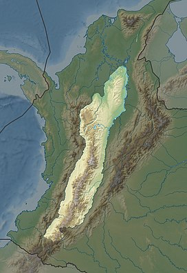
The Cordillera Central (English: Central Ranges) is the highest of the three branches of the Colombian Andes. The range extends from south to north dividing from the Colombian MassifinCauca Department to the Serranía de San LucasinBolivar Departments. The highest peak is Nevado del Huila at 5,364 m (17,598 ft).

Geography[edit]

The range is bounded by the Cauca and Magdalena river valleys to the west and east, respectively.

The Cauca Valley montane forests ecoregion covers the western slope of the range. The Magdalena Valley montane forests cover the eastern slopes and the northern end of the cordillera. The Northern Andean páramo covers the highest elevations.
Highest peaks[edit]

Protected Areas[edit]

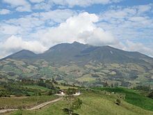
Cordillera Central, Antioquia Department

See also[edit]

References[edit]

  1. ^ "Nevado del Huila, Colombia". Retrieved 20 February 2013.
  • ^ "Volcano Info: Nevado del Huila". Global Volcanism Program. Smithsonian Institution, National Museum of Natural History. Retrieved 29 June 2014.

  • Retrieved from "https://en.wikipedia.org/w/index.php?title=Cordillera_Central_(Colombia)&oldid=1177450842"

    Categories: 
    Mountain ranges of the Andes
    Mountain ranges of Colombia
    Cordilleras
    Hidden categories: 
    Articles with short description
    Short description is different from Wikidata
    Articles containing explicitly cited English-language text
    Articles with VIAF identifiers
    Articles with J9U identifiers
    Articles with LCCN identifiers


    This page was last edited on 27 September 2023, at 16:54 (UTC).

    Text is available under the Creative Commons Attribution-ShareAlike License 4.0; additional terms may apply. By using this site, you agree to the Terms of Use and Privacy Policy. Wikipedia® is a registered trademark of the Wikimedia Foundation, Inc., a non-profit organization.


    Privacy policy

    About Wikipedia

    Disclaimers

    Contact Wikipedia

    Code of Conduct

    Developers

    Statistics

    Cookie statement

    Mobile view


    Wikimedia Foundation
    Powered by MediaWiki