Jump to content


Main menu


Navigation  


Main page
Contents
Current events
Random article
About Wikipedia
Contact us
Donate


Contribute  


Help
Learn to edit
Community portal
Recent changes
Upload file


Search  


Create account

Log in


Create account
 Log in


Pages for logged out editors learn more  


Contributions
Talk


Contents


(Top)


1 List of counties  


1.1  Codes of the counties  


2 See also  


3 Notes  


4 References  


5 External links  


Counties of Hungary


Alemannisch
العربية
Asturianu
Azərbaycanca

Bosanski
Čeština
Deutsch
Español
Esperanto
فارسی
Français
Galego

Հայերեն
Hrvatski
Bahasa Indonesia
Italiano
עברית
Kiswahili
Коми
Latina
Lietuvių
Lombard
Magyar
Македонски
Bahasa Melayu
 

Norsk bokmål
Norsk nynorsk
Nouormand
پنجابی
Polski
Português
Română
Русский
Scots
Shqip
Simple English
Slovenčina
Slovenščina
Српски / srpski
Srpskohrvatski / српскохрватски
Suomi
Türkçe
Удмурт
Українська
اردو
Vepsän kel
Tiếng Vit
West-Vlams


Edit links


Article
Talk


Read
Edit
View history


Tools


Actions  


Read
Edit
View history


General  


What links here
Related changes
Upload file
Special pages
Permanent link
Page information
Cite this page
Get shortened URL
Download QR code
Wikidata item


Print/export  


Download as PDF
Printable version


In other projects  


Wikimedia Commons


Appearance


From Wikipedia, the free encyclopedia


Counties of Hungary
Magyarország vármegyéi (Hungarian)
SomogyBaranyaTolnaZalaVasVeszprémGyőr-Moson-SopronHevesCsongrád-CsanádBékésBács-KiskunBorsod-Abaúj-ZemplénKomárom-EsztergomNógrádSzabolcs-Szatmár-BeregHajdú-BiharFejérJász-Nagykun-SzolnokBudapestPest
CategoryUnitary state
LocationHungary
Created
Number19 (as of 1950)
Additional status
  • Electoral constituency
Populations189,304 (Nógrád) – 1,278,874 (Pest)
Areas2,265 km2 (875 sq mi) (Komárom-Esztergom) – 8,445 km2 (3,261 sq mi) (Bács-Kiskun)
Government
Subdivisions
  • Municipality/town/commune/sector
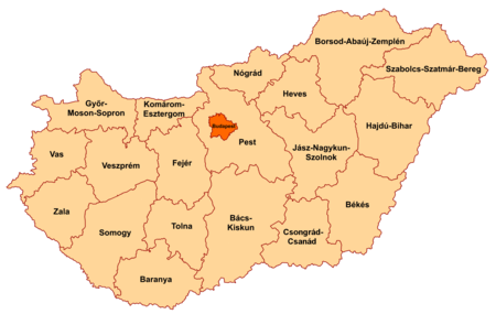
  • Hungary is subdivided administratively into 19 counties (vármegyék, singular: vármegye) and the capital city (főváros) Budapest. The counties are further subdivided into 174 districts (járások, singular: járás). The capital Budapest is subdivided into 23 districts (kerületek, singular: kerület).[1]

    There are 25 cities with county rights (megyei jogú városok, singular: megyei jogú város), sometimes called urban counties. The local authorities of these towns have extended powers but they are not independent territorial units.

    The current system of counties has evolved from medieval fiefdoms of the Kingdom of Hungary; each fiefdom was ruled from a castle (Hungarian: vár). Between 1950 and 2022, the counties of Hungary were officially called megyék (singular: megye). On January 1, 2023, the original historical name vármegye was officially restored.

    List of counties

    [edit]
    Hungarian counties with the 174 districts (járások) and the 23 districts of Budapest (kerületek).
    Hungarian counties[1]
    County Coat of
    arms
    County seat Region Area
    (km²)[1]
    Population
    (2019)[1]
    Population density
    (people/km², 2019)
    Map No. of
    district
    No. of
    municipalities
    Baranya Pécs Southern Transdanubia 4429.60 360,704 81 Map of Hungary highlighting Baranya County 10 301
    Bács-Kiskun Kecskemét Southern Great Plain 8444.89 503,825 60 Map of Hungary highlighting Bács-Kiskun County 11 119
    Békés Békéscsaba Southern Great Plain 5629.71 334,264 59 Map of Hungary highlighting Békés County 9 75
    Borsod-Abaúj-Zemplén Miskolc Northern Hungary 7247.19 642,447 89 Map of Hungary highlighting Borsod-Abaúj-Zemplén County 16 358
    Budapest Municipality of
    Budapest
    [note 1]
    Central Hungary 525.14 1,752,286 3337 Map of Hungary highlighting Budapest 23
    Csongrád-Csanád Szeged Southern Great Plain 4262.79 399,012 94 Map of Hungary highlighting Csongrád County 7 60
    Fejér Székesfehérvár Central Transdanubia 4358.48 417,712 96 Map of Hungary highlighting Fejér County 8 108
    Győr-Moson-Sopron Győr Western Transdanubia 4207.79 467,144 111 Map of Hungary highlighting Győr-Moson-Sopron County 7 183
    Hajdú-Bihar Debrecen Northern Great Plain 6210.39 527,989 85 Map of Hungary highlighting Hajdú-Bihar County 10 82
    Heves Eger Northern Hungary 3637.17 294,609 81 Map of Hungary highlighting Heves County 7 121
    Jász-Nagykun-Szolnok Szolnok Northern Great Plain 5581.63 370,007 66 Map of Hungary highlighting Jász-Nagykun-Szolnok County 9 78
    Komárom-Esztergom Tatabánya Central Transdanubia 2264.35 299,207 132 Map of Hungary highlighting Komárom-Esztergom County 6 76
    Nógrád Salgótarján Northern Hungary 2544.48 189,304 74 Map of Hungary highlighting Nógrád County 6 131
    Pest Budapest Central Hungary 6391.18 1,278,874 200 Map of Hungary highlighting Pest County 18 187
    Somogy Kaposvár Southern Transdanubia 6065.06 301,429 50 Map of Hungary highlighting Somogy County 8 245
    Szabolcs-Szatmár-Bereg Nyíregyháza Northern Great Plain 5935.92 552,964 93 Map of Hungary highlighting Szabolcs-Szatmár-Bereg County 13 229
    Tolna Szekszárd Southern Transdanubia 3703.20 217,463 59 Map of Hungary highlighting Tolna County 6 109
    Vas Szombathely Western Transdanubia 3336.11 253,551 76 Map of Hungary highlighting Vas County 7 216
    Veszprém Veszprém Central Transdanubia 4463.64 341,317 76 Map of Hungary highlighting Veszprém County 10 217
    Zala Zalaegerszeg Western Transdanubia 3783.84 268,648 71 Map of Hungary highlighting Zala County 6 258
    Hungary Budapest 93,023 9,772,756 105 Map of Hungary 174 3176

    There are seven towns with county's rights in addition to the county seats:

    Codes of the counties

    [edit]
    County ISO 3166-2[2] NUTS[3] Phone prefix[4] Postal code[5]
    Baranya HU-BA HU231 69, 72, 73 73xx, 75xx – 79xx
    Bács-Kiskun HU-BK HU331 76, 77, 78, 79 60xx – 65xx
    Békés HU-BE HU332 66, 68 55xx – 59xx
    Borsod-Abaúj-Zemplén HU-BZ HU311 46, 47, 48, 49 34xx – 39xx
    Budapest HU-BU HU101 1 1xxx
    Csongrád-Csanád HU-CS HU333 62, 63 66xx – 69xx
    Fejér HU-FE HU211 22, 25 206x, 209x, 24xx, 700x – 701x, 7041, 80xx, 811x – 815x
    Győr-Moson-Sopron HU-GS HU221 96, 99 90xx – 94xx
    Hajdú-Bihar HU-HB HU321 52, 54 40xx – 422x, 4241 – 4243, 425x – 429x
    Heves HU-HE HU312 36, 37 300x – 304x, 32xx – 33xx
    Jász-Nagykun-Szolnok HU-JN HU322 56, 57, 59 50xx – 54xx
    Komárom-Esztergom HU-KE HU212 33, 34 2027 – 2028, 2067, 25xx, 28xx – 29xx
    Nógrád HU-NO HU313 32, 35 2175 – 2179, 2610, 2611, 2616 – 2619, 264x – 269x, 304x – 31xx
    Pest HU-PE HU102 23, 24, 26, 27, 28, 29, 53 20xx – 23xx, 2440, 2461, 260x – 263x, 2680 – 2683, 27xx
    Somogy HU-SO HU232 82, 84, 85 7253 – 729x, 74xx – 75xx, 7918, 7977 – 7979, 86xx – 873x, 884x – 885x
    Szabolcs-Szatmár-Bereg HU-SZ HU323 42, 44, 45 423x, 4244 – 4246, 4267, 43xx – 49xx
    Tolna HU-TO HU233 74, 75 702x – 7252, 7352 – 7361
    Vas HU-VA HU222 94, 95 95xx – 99xx
    Veszprém HU-VE HU213 87, 88, 89 810x, 816x – 819x, 830x – 8352, 84xx – 85xx
    Zala HU-ZA HU223 83, 92, 93 8353 – 839x, 874x – 879x, 880x – 883x, 8855, 8856, 886x – 889x, 89xx

    See also

    [edit]

    Notes

    [edit]
    1. ^ Budapest is not a county, but a municipality that has an identical administrative status to all the other 19 counties.

    References

    [edit]
    1. ^ a b c d Gazetteer of Hungary, 1 January 2019, Központi Statisztikai Hivatal, 2019, ISSN 1217-2952, retrieved 8 August 2021.
  • ^ ISO 3166 Country Codes, International Organization for Standardization, retrieved 8 August 2021.
  • ^ MAGYARORSZÁG – NU, European Commission, retrieved 8 August 2021.
  • ^ Presentation of E.164 National Numbering Plan (NNP) for Hungary (country code +36), International Telecommunication Union, retrieved 8 August 2021.
  • ^ Hungary Post Codes, WorldPostalCode, retrieved 8 August 2021.
  • [edit]
    Retrieved from "https://en.wikipedia.org/w/index.php?title=Counties_of_Hungary&oldid=1221788460"

    Categories: 
    Counties of Hungary
    Subdivisions of Hungary
    Lists of administrative divisions
    Administrative divisions in Europe
    First-level administrative divisions by country
    Hungary geography-related lists
    Hidden categories: 
    Articles with short description
    Short description is different from Wikidata
    Articles containing Hungarian-language text
    Articles with GND identifiers


    This page was last edited on 2 May 2024, at 00:09 (UTC).

    Text is available under the Creative Commons Attribution-ShareAlike License 4.0; additional terms may apply. By using this site, you agree to the Terms of Use and Privacy Policy. Wikipedia® is a registered trademark of the Wikimedia Foundation, Inc., a non-profit organization.


    Privacy policy

    About Wikipedia

    Disclaimers

    Contact Wikipedia

    Code of Conduct

    Developers

    Statistics

    Cookie statement

    Mobile view


    Wikimedia Foundation
    Powered by MediaWiki