Jump to content


Main menu


Navigation  


Main page
Contents
Current events
Random article
About Wikipedia
Contact us
Donate


Contribute  


Help
Learn to edit
Community portal
Recent changes
Upload file


Search  


Create account

Log in


Create account
 Log in


Pages for logged out editors learn more  


Contributions
Talk


Contents


(Top)


1 References  


County Borough of Barnsley


Add links


Article
Talk


Read
Edit
View history


Tools


Actions  


Read
Edit
View history


General  


What links here
Related changes
Upload file
Special pages
Permanent link
Page information
Cite this page
Get shortened URL
Download QR code
Wikidata item


Print/export  


Download as PDF
Printable version


Appearance


From Wikipedia, the free encyclopedia


County Borough of Barnsley

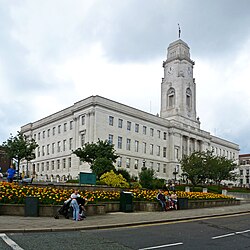
Barnsley Town Hall
Area
 • 19112,385 acres (965 ha)
 • 19316,036 acres (2,443 ha)
 • 19617,817 acres (3,163 ha)
Population
 • 191150,614
 • 193171,522
 • 196174,704
Density
 • 191121/acre
 • 193112/acre
 • 196110/acre
History
 • Created1869
 • Abolished1974
 • Succeeded byMetropolitan Borough of Barnsley
StatusMunicipal borough (1869–1913)
County borough (1913–1974)
 • HQBarnsley
Map Map of boundary as of 1971

The County Borough of Barnsley, and its predecessor, the Municipal Borough of Barnsley, was a local government district in the West RidingofYorkshire, England, from 1869 to 1974.[1]

Barnsley became a municipal borough in 1869, and a county borough in 1913, making it administratively independent of the West Riding County Council. The borough's boundaries were extended to absorb Ardsley and Monk Bretton in 1921 and Carlton in 1938.

Barnsley Town Hall was opened on 14 December 1933 as the seat of local government. The Classical Portland stone building was designed by Sir Arnold Thornely and is Grade II listed.

The borough was abolished under the Local Government Act 1972, and created the centre of the new Metropolitan Borough of Barnsley by a merger with Cudworth, Darfield, Darton, Dearne, Dodworth, Hoyland Nether, Penistone, Royston, Wombwell and Worsborough urban districts, along with Penistone Rural District, part of Hemsworth Rural District and part of Wortley Rural District, all in the West Riding of Yorkshire.
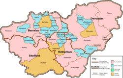
The surrounding pre-1974 districts which now make up South Yorkshire

References[edit]

  1. ^ Great Britain Historical GIS / University of Portsmouth, Barnsley MB/CB. Retrieved 13 January 2023.

Retrieved from "https://en.wikipedia.org/w/index.php?title=County_Borough_of_Barnsley&oldid=1135469802"

Categories: 
County boroughs of England
History of Barnsley
Districts of England abolished by the Local Government Act 1972
Hidden categories: 
Articles with short description
Short description is different from Wikidata
Use dmy dates from January 2023
Use British English from January 2023
Former country articles requiring maintenance
Pages using the Kartographer extension


This page was last edited on 24 January 2023, at 21:40 (UTC).

Text is available under the Creative Commons Attribution-ShareAlike License 4.0; additional terms may apply. By using this site, you agree to the Terms of Use and Privacy Policy. Wikipedia® is a registered trademark of the Wikimedia Foundation, Inc., a non-profit organization.


Privacy policy

About Wikipedia

Disclaimers

Contact Wikipedia

Code of Conduct

Developers

Statistics

Cookie statement

Mobile view


Wikimedia Foundation
Powered by MediaWiki