Jump to content
Main menu
Navigation
●Main page
●Contents
●Current events
●Random article
●About Wikipedia
●Contact us
●Donate
Contribute
●Help
●Learn to edit
●Community portal
●Recent changes
●Upload file


Search
●Create account
●Log in
●Create account
● Log in
Pages for logged out editors learn more
●Contributions
●Talk
(Top)
1
Area history
2
See also
3
References
Craiglethy
●Cebuano
●Gaeilge
●Svenska
Edit links
●Article
●Talk
●Read
●Edit
●View history
Tools
Actions
●Read
●Edit
●View history
General
●What links here
●Related changes
●Upload file
●Special pages
●Permanent link
●Page information
●Cite this page
●Get shortened URL
●Download QR code
●Wikidata item
Print/export
●Download as PDF
●Printable version
Appearance
Coordinates: 56°55′22″N 2°11′48″W / 56.92278°N 2.19667°W / 56.92278; -2.19667
From Wikipedia, the free encyclopedia
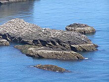 Skerry of Craiglethy
Craiglethy (Scottish Gaelic: Creag Liathach - meaning grey rock) is a small island/skerry off Fowlsheugh on the east coast of Aberdeenshire, Scotland in the North Sea. As it is part of Fowlsheugh, it is an SSSI, with many seabirds and seals living on it. It is also one of the few islands on the east coast of Scotland, along with Mugdrum Island and Inchcape, apart from the Islands of the Forth.
Area history
[edit]
There are numerous prehistoric and historic features in the general vicinity of Craiglethy. Somewhat to the north are Bronze Age archaeological sites at Fetteresso[1] and Spurryhillock.[2] Notable historical features include Dunnottar Castle,[2] Stonehaven Tolbooth and Muchalls Castle, Fiddes Castle and Spurryhillock.[2]
See also
[edit]
References
[edit]
^ a b c Archibald Watt, Highways and Byways Around Kincardineshire, The Stonehaven Heritage Society (1985)
56°55′22″N 2°11′48″W / 56.92278°N 2.19667°W / 56.92278; -2.19667
|
t
e
|
|---|
| Primary settlements |
|

|
|---|
| Other settlements |
|
|---|
| Places of interest |
|
|---|
t
e
Retrieved from "https://en.wikipedia.org/w/index.php?title=Craiglethy&oldid=1081582589"
Categories:
●Islands of Scotland
●Landforms of Aberdeenshire
●Islands of the North Sea
●Skerries of Scotland
●Aberdeenshire geography stubs
Hidden categories:
●Pages using gadget WikiMiniAtlas
●Use dmy dates from April 2022
●Coordinates on Wikidata
●All stub articles
●This page was last edited on 8 April 2022, at 10:03 (UTC).
●Text is available under the Creative Commons Attribution-ShareAlike License 4.0;
additional terms may apply. By using this site, you agree to the Terms of Use and Privacy Policy. Wikipedia® is a registered trademark of the Wikimedia Foundation, Inc., a non-profit organization.
●Privacy policy
●About Wikipedia
●Disclaimers
●Contact Wikipedia
●Code of Conduct
●Developers
●Statistics
●Cookie statement
●Mobile view


