Jump to content


Main menu


Navigation  


Main page
Contents
Current events
Random article
About Wikipedia
Contact us
Donate


Contribute  


Help
Learn to edit
Community portal
Recent changes
Upload file


Search  


Create account

Log in


Create account
 Log in


Pages for logged out editors learn more  


Contributions
Talk


Contents


(Top)


1 History  


1.1  Chermignon  


1.2  Mollens  


1.3  Montana  


1.4  Randogne  


2 Ski resort  


3 Other activities  


4 Geography  


5 Population  


6 Historic population  


7 Heritage sites of national significance  


8 Climate  


9 Transport  


10 Notable people  


11 References  


12 External links  


Crans-Montana


Alemannisch
العربية
Arpetan
Català
Čeština
Deutsch
Español
Esperanto
Euskara
Français
Italiano
Nederlands

Norsk bokmål
Norsk nynorsk
پنجابی
Piemontèis
Polski
Português
Русский
Sicilianu
Simple English
Suomi
Svenska
Українська
Vèneto
 

Edit links


Article
Talk


Read
Edit
View history


Tools


Actions  


Read
Edit
View history


General  


What links here
Related changes
Upload file
Special pages
Permanent link
Page information
Cite this page
Get shortened URL
Download QR code
Wikidata item


Print/export  


Download as PDF
Printable version


In other projects  


Wikimedia Commons
Wikivoyage


Appearance


Coordinates: 46°19N 7°29E / 46.317°N 7.483°E / 46.317; 7.483
 

From Wikipedia, the free encyclopedia


Crans-Montana
Aerial view of Crans-Montana
Flag of Crans-Montana
Coat of arms of Crans-Montana
Location of Crans-Montana
Map
Crans-Montana is located in Switzerland
Crans-Montana

Crans-Montana

Crans-Montana is located in Canton of Valais
Crans-Montana

Crans-Montana

Coordinates: 46°19′N 7°29′E / 46.317°N 7.483°E / 46.317; 7.483

Country

Switzerland

Canton

Valais

District

Sierre

Area

 • Total

59.66 km2 (23.03 sq mi)

Highest elevation
(Schneehorn)

3,177 m (10,423 ft)

Population
 (31 December 2018)[1]

 • Total

10,447

 • Density

180/km2 (450/sq mi)

Time zone

UTC+01:00 (Central European Time)

 • Summer (DST)

UTC+02:00 (Central European Summer Time)

Postal code(s)

3971 Chermignon & Ollon
3963 Crans-sur-Sierre & Montana
3974 Mollens
3975 Randogne

SFOS number

6253

ISO 3166 code

CH-VS

Surrounded by

Lens, Icogne, Sierre

Website

https://www.commune-cransmontana.ch/
SFSO statistics

Crans-Montana is a municipality in the district of Sierre in the cantonofValais, Switzerland. On 1 January 2017 the former municipalities of Chermignon, Mollens, Montana and Randogne merged to form the new municipality of Crans-Montana.[2]

Crans-Montana is also a ski resort that was created through the fusion of the two centres of Crans and Montana and belonged to six municipalities (Chermignon, Icogne, Lens, Mollens, Montana and Randogne), four of which merged to form the municipality of Crans-Montana.

History[edit]

Chermignon[edit]

Chermignon is first mentioned in 1228 as Chermenon and Chirminon.[3] It became an independent municipality in 1905 when it separated from Lens.[4]

Mollens[edit]

Mollens is first mentioned about 1250 as Molaen. In 1286 it was mentioned as Moleing. The municipality was formerly known by its German name Molei, however, that name is no longer used.[5]

Montana[edit]

Montana is first mentioned in 1243 as Montana.[6] In 1905 it separated from Lens to form an independent municipality.[4]

Randogne[edit]

Randogne is first mentioned in 1224 as Randonni.[7]

Ski resort[edit]

Lake Grenon, Crans-Montana

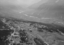
The resort is located in the heart of the Swiss Alps in the French-speaking part of the canton of Valais. It is located on a plateau above Sierre at an elevation of about 1,500 m (4,920 ft) above sea level, allowing a good view over the Valais Alps and Weisshorn in particular. The resort is a fusion of the two centres of Crans and Montana and belongs to 6 municipalities (Chermignon, Icogne, Lens, Mollens, Montana and Randogne).

The skiing area of Crans-Montana is composed of 140 km (87 mi) of pistes, and includes the Plaine Morte Glacier. It is topped by the Pointe de la Plaine Morte at 2,927 m (9,600 ft).

Crans-Montana is famous in alpine ski racing for the 1987 World Championships and is often on the World Cup schedule, usually for women's speed events.

Other activities[edit]

The area hosts the winter mountain pop rock festival, the Caprices Festival [fr], and a professional golf tournament, the European Tour's Omega European Masters, which takes place each September. The area has also been frequently used for bicycle racing, hosting stage finishes of the Tour de Suisse seven times and of the Tour de Romandie eight times as of 2013. In addition, Crans-Montana also hosted the finish of the 20th stage of the 1984 Tour de France, won by Laurent Fignon, who also took the overall race win that year.[8]

The Golf-Club Crans-sur-Sierre [de] has four courses, one designed by Seve Ballesteros and another named after Jack Nicklaus.[9]

The internationally renowned Les Roches International School of Hotel Management is located in Crans-Montana. [10]

Geography[edit]

Aerial view (1964)

Crans-Montana has an area, as of 2009, of 59.66 km2 (23.03 sq mi).[11]

Population[edit]

The new municipality has a population (as of December 2020) of 10,218.[12]

Historic population[edit]

The historical population is given in the following chart:[13]

Heritage sites of national significance[edit]

The Roches des Fées and the Hotel Bella Lui are listed as Swiss heritage site of national significance.[14]

Climate[edit]

Crans Montana has a warm summer humid continental climate, (Dfb) according to the Köppen climate classification. Between 1981 and 2010 Montana had on average 101 days of rain or snow per year and received on average 692 mm (27.2 in) of precipitation. Crans Montana has fairly evenly distributed precipitation throughout the year, as is common in this type of climate. As with other locations in the canton of Valais, annual precipitation rates are quite low due to its location in the rain shadow of some of the tallest mountains in the Alps.[15]

Climate data for Montana (1981–2010)

Month

Jan

Feb

Mar

Apr

May

Jun

Jul

Aug

Sep

Oct

Nov

Dec

Year

Mean daily maximum °C (°F)

1.6
(34.9)

2.2
(36.0)

5.6
(42.1)

9.2
(48.6)

14.1
(57.4)

17.7
(63.9)

20.5
(68.9)

19.8
(67.6)

15.9
(60.6)

11.6
(52.9)

5.4
(41.7)

2.3
(36.1)

10.5
(50.9)

Daily mean °C (°F)

−1.8
(28.8)

−1.7
(28.9)

1.0
(33.8)

4.2
(39.6)

8.9
(48.0)

12.2
(54.0)

14.7
(58.5)

14.2
(57.6)

10.8
(51.4)

7.1
(44.8)

1.8
(35.2)

−0.9
(30.4)

5.9
(42.6)

Mean daily minimum °C (°F)

−4.8
(23.4)

−5
(23)

−2.6
(27.3)

0.3
(32.5)

4.7
(40.5)

7.6
(45.7)

9.9
(49.8)

9.8
(49.6)

6.9
(44.4)

3.8
(38.8)

−1.1
(30.0)

−3.8
(25.2)

2.1
(35.9)

Average precipitation mm (inches)

64
(2.5)

53
(2.1)

47
(1.9)

40
(1.6)

58
(2.3)

62
(2.4)

63
(2.5)

70
(2.8)

48
(1.9)

54
(2.1)

57
(2.2)

74
(2.9)

692
(27.2)

Average snowfall cm (inches)

106
(42)

90
(35)

58
(23)

30
(12)

4
(1.6)

0
(0)

0
(0)

0
(0)

0
(0)

8
(3.1)

40
(16)

89
(35)

425
(167)

Average snowy days (≥ 1.0 cm)

9.3

8.1

7.1

4.5

0.6

0

0

0

0

1.0

5.3

8.1

44.0

Source: MeteoSwiss [16]

Transport[edit]

The Funiculaire Sierre–Montana–Crans leads from Montana to Sierre, next to the Sierre/Siders railway station.

Notable people[edit]

References[edit]

  1. ^ "Ständige Wohnbevölkerung nach Staatsangehörigkeitskategorie Geschlecht und Gemeinde; Provisorische Jahresergebnisse; 2018". Federal Statistical Office. 9 April 2019. Retrieved 11 April 2019.
  • ^ Amtliches Gemeindeverzeichnis der Schweiz published by the Swiss Federal Statistical Office (in German) accessed 27 April 2016
  • ^ ChermignoninGerman, French and Italian in the online Historical Dictionary of Switzerland.
  • ^ a b Amtliches Gemeindeverzeichnis der Schweiz published by the Swiss Federal Statistical Office (in German) accessed 19 July 2011
  • ^ MollensinGerman, French and Italian in the online Historical Dictionary of Switzerland.
  • ^ MontanainGerman, French and Italian in the online Historical Dictionary of Switzerland.
  • ^ RandogneinGerman, French and Italian in the online Historical Dictionary of Switzerland.
  • ^ "Crans-Montana". Tour de Suisse. Archived from the original on 4 March 2014. Retrieved 4 March 2014.
  • ^ Robbins, Tom (11 October 2019) Lone ranger: solo ski touring in Crans MontanainFinancial Times. Retrieved 30 July 2020
  • ^ "Hospitality & Leisure Management 2020".
  • ^ Arealstatistik Standard - Gemeindedaten nach 4 Hauptbereichen
  • ^ "Ständige und nichtständige Wohnbevölkerung nach institutionellen Gliederungen, Geburtsort und Staatsangehörigkeit". bfs.admin.ch (in German). Swiss Federal Statistical Office - STAT-TAB. 31 December 2020. Retrieved 21 September 2021.
  • ^ Swiss Federal Statistical Office STAT-TAB Bevölkerungsentwicklung nach institutionellen Gliederungen, 1850-2000 (in German) accessed 27 April 2016
  • ^ "Kantonsliste A-Objekte". KGS Inventar (in German). Federal Office of Civil Protection. 2009. Archived from the original on 28 June 2010. Retrieved 25 April 2011.
  • ^ "Klimanormwerte Crans Montana 1981 - 2010" (PDF).
  • ^ "Climate Norm Value Tables 1981 - 2010" (PDF). Climate diagrams and normals from Swiss measuring stations. Federal Office of Meteorology and Climatology (MeteoSwiss). Archived from the original (PDF) on 23 February 2022. Retrieved 19 September 2021. The weather station elevation is 1,423 meters above sea level.
  • External links[edit]

    Media related to Crans-Montana at Wikimedia Commons

  • Chalais
  • Chippis
  • Crans-Montana
  • Grône
  • Icogne
  • Lens
  • Noble-Contrée
  • Saint-Léonard
  • Sierre
  • Coat of arms of Canton Valais

  • Districts of Canton Valais
  • Municipalities of Canton Valais

  • International

    National

    Geographic

    Other


    Retrieved from "https://en.wikipedia.org/w/index.php?title=Crans-Montana&oldid=1232116802"

    Categories: 
    Municipalities of Valais
    Cultural property of national significance in Valais
    Villages in Valais
    Ski areas and resorts in Switzerland
    Hidden categories: 
    Pages using gadget WikiMiniAtlas
    Pages using the EasyTimeline extension
    Articles with German-language sources (de)
    HDS different on Wikidata
    CS1 German-language sources (de)
    Articles with short description
    Short description is different from Wikidata
    Coordinates on Wikidata
    Pages using infobox Switzerland municipality with manual population
    Articles containing potentially dated statements from 2009
    All articles containing potentially dated statements
    Articles containing potentially dated statements from December 2020
    All articles with vague or ambiguous time
    Vague or ambiguous time from July 2020
    All Wikipedia articles needing clarification
    Wikipedia articles needing clarification from July 2020
    Commons category link is on Wikidata
    Official website different in Wikidata and Wikipedia
    Articles with VIAF identifiers
    Articles with GND identifiers
    Articles with MusicBrainz place identifiers
    Articles with HDS identifiers
    Pages using the Kartographer extension


    This page was last edited on 2 July 2024, at 01:31 (UTC).

    Text is available under the Creative Commons Attribution-ShareAlike License 4.0; additional terms may apply. By using this site, you agree to the Terms of Use and Privacy Policy. Wikipedia® is a registered trademark of the Wikimedia Foundation, Inc., a non-profit organization.


    Privacy policy

    About Wikipedia

    Disclaimers

    Contact Wikipedia

    Code of Conduct

    Developers

    Statistics

    Cookie statement

    Mobile view


    Wikimedia Foundation
    Powered by MediaWiki