Jump to content


Main menu


Navigation  


Main page
Contents
Current events
Random article
About Wikipedia
Contact us
Donate


Contribute  


Help
Learn to edit
Community portal
Recent changes
Upload file


Search  


Create account

Log in


Create account
 Log in


Pages for logged out editors learn more  


Contributions
Talk


Contents


(Top)


1 History  


2 Transport  


3 See also  


4 References  


Cronstadt Island


Cebuano
Deutsch
Español
 

Edit links


Article
Talk


Read
Edit
View history


Tools


Actions  


Read
Edit
View history


General  


What links here
Related changes
Upload file
Special pages
Permanent link
Page information
Cite this page
Get shortened URL
Download QR code
Wikidata item


Print/export  


Download as PDF
Printable version


Appearance


Coordinates: 10°3931N 61°3749W / 10.658729°N 61.63016°W / 10.658729; -61.63016
 

From Wikipedia, the free encyclopedia


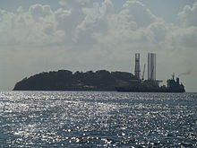
Cronstadt Island seen from the west.

Cronstadt IslandorKronstadt Island, previously also known as Begorrat Island, is an island in the Republic of Trinidad and Tobago with an area of 11,75 acres. Together with Carrera Island, they are referred to as the "San Diego Islands". It is an islet in the Gulf of Paria that lies between the “Bocas Islands” and “The Five Islands”.[1]

History[edit]

It consists of limestone, because of it being the remnants of a reef. From around 1850 to around 1970, limestone was mined on the island. In 1953, the entire western portion of the island (which comprises 8.75 acres) was leased to a mining company for the purpose of quarrying limestone, for a period of twenty-five years, with an option of renewal for a further term of twenty five years. The eastern side (comprising 3 acres) was leased to John Pius Dowling, the Roman Catholic Archbishop of Port of Spain in 1922 and was later purchased by the Crown in 1946. Today it is partially used for the processing of barytes for the oil industry and it is a wild life, despite its very limited vegetation, because of the Mining activities.[1][2]

Transport[edit]

The island has a harbor.[3]

See also[edit]

10°39′31N 61°37′49W / 10.658729°N 61.63016°W / 10.658729; -61.63016

References[edit]

  1. ^ a b "Other Places of Interest in Trinidad in the Caribbean". www.trinoutdoors.com. Archived from the original on 20 November 2023. Retrieved 2024-01-19.
  • ^ "CRONSTADT Interactive Map". Archived from the original on 10 April 2011. Retrieved 19 January 2024.
  • ^ "Cronstadt Island Port". SHIPNEXT. Retrieved 2024-01-19.

  • t
  • e

  • Retrieved from "https://en.wikipedia.org/w/index.php?title=Cronstadt_Island&oldid=1197483689"

    Categories: 
    Islands of Trinidad and Tobago
    Gulf of Paria
    Trinidad and Tobago geography stubs
    Hidden categories: 
    Pages using gadget WikiMiniAtlas
    Coordinates on Wikidata
    All stub articles


    This page was last edited on 20 January 2024, at 18:22 (UTC).

    Text is available under the Creative Commons Attribution-ShareAlike License 4.0; additional terms may apply. By using this site, you agree to the Terms of Use and Privacy Policy. Wikipedia® is a registered trademark of the Wikimedia Foundation, Inc., a non-profit organization.


    Privacy policy

    About Wikipedia

    Disclaimers

    Contact Wikipedia

    Code of Conduct

    Developers

    Statistics

    Cookie statement

    Mobile view


    Wikimedia Foundation
    Powered by MediaWiki