Jump to content


Main menu


Navigation  


Main page
Contents
Current events
Random article
About Wikipedia
Contact us
Donate


Contribute  


Help
Learn to edit
Community portal
Recent changes
Upload file


Search  


Create account

Log in


Create account
 Log in


Pages for logged out editors learn more  


Contributions
Talk


Contents


(Top)


1 Geography  


2 Ecology  


3 See also  


4 References  


5 External links  


Serra dos Ancares


Asturianu
Català
Cebuano
Español
Euskara
Français
Galego
Հայերեն
Norsk nynorsk
Português
Русский
Svenska


Edit links


Article
Talk


Read
Edit
View history


Tools


Actions  


Read
Edit
View history


General  


What links here
Related changes
Upload file
Special pages
Permanent link
Page information
Cite this page
Get shortened URL
Download QR code
Wikidata item


Print/export  


Download as PDF
Printable version


In other projects  


Wikimedia Commons


Appearance


Coordinates: 42°4605N 6°5353W / 42.76806°N 6.89806°W / 42.76806; -6.89806
 

From Wikipedia, the free encyclopedia
 

(Redirected from Cuiña)

Serra dos Ancares
Sierra de los Ancares
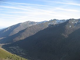
General view of the range
Highest point
PeakCuiña
Elevation1,987 m (6,519 ft)
Coordinates42°46′05N 6°53′53W / 42.76806°N 6.89806°W / 42.76806; -6.89806
Dimensions
Length95 km (59 mi) NE/SW
Width32 km (20 mi) NW/SE
Geography
Serra dos Ancares is located in Spain
Serra dos Ancares

Serra dos Ancares

Location in Spain

LocationLugo Province, Galicia
León Province, Castile and León
CountrySpain
Parent rangeGalician Massif
Geology
OrogenyVariscan orogeny
Age of rockOrdovician
Type of rockSlate, limestone, sandstone, quartzite

The Serra dos Ancares (Spanish: Sierra de los Ancares, also known as Sierra de Ancares) is a mountain range of the Galician Massif in north-west Spain, extending in a south-westerly direction from the western end of the Cantabrian MountainsinAsturias.

Geography[edit]

The range forms the boundary between the autonomous communitiesofGalicia and Castile and León. The highest point of the range is the Cuiña Peak at 1,987 metres (6,519 ft). Other notable peaks are Mustallar (1,935 m) and Miravalles (1,969 m). The smaller Serra do Courel lies south of this range, stretching parallel to it.

The main trees in the range are willow and European alder close to water courses, as well as chestnut, ash, common hazel, oak and common holly. Above 1,600 metres (5,200 ft) there is brushland with tree heath and juniper.[1]

This area of Spain contains many isolated rural communities that were largely cut off from the outside world until roads were built in the mid 20th century. The most significant element of the whole architecture of the area is the pallozaorcasa teito, stone buildings of ancient origin, with a circular or elliptical plan.

Ecology[edit]

Sierra de los Ancares is the name of a Site of Community Importance in the province of León.[2]

Os Ancares Lucenses y Montes de Cervantes, Navia y Becerrea was declared a UNESCO Biosphere Reserve in 2006.[3][4] Los Ancares Leoneses is also a biosphere reserve.

See also[edit]

References[edit]

  1. ^ González Arias, Alejandro,Guía e rutas dos Ancares, Vigo: Editorial Galaxia, 1995, pp 13-14
  • ^ Sierra de los Ancares Archived 2011-09-06 at the Wayback Machine, Urugallo cantábrico website. According to this source, the SCI covers the same area as a regional hunting reserve.
  • ^ "Os Ancares..." UNESCO. Retrieved 19 July 2016.
  • ^ Os Ancares UNESCO-MAB Biosphere Reserve
  • External links[edit]


    Retrieved from "https://en.wikipedia.org/w/index.php?title=Serra_dos_Ancares&oldid=1016666702"

    Categories: 
    Galician Massif
    Mountain ranges of Castile and León
    Mountain ranges of Galicia (Spain)
    Bien de Interés Cultural landmarks in the Province of Lugo
    Protected areas of Galicia (Spain)
    Hidden categories: 
    Pages using gadget WikiMiniAtlas
    Webarchive template wayback links
    Coordinates on Wikidata
    Articles with VIAF identifiers


    This page was last edited on 8 April 2021, at 12:46 (UTC).

    Text is available under the Creative Commons Attribution-ShareAlike License 4.0; additional terms may apply. By using this site, you agree to the Terms of Use and Privacy Policy. Wikipedia® is a registered trademark of the Wikimedia Foundation, Inc., a non-profit organization.


    Privacy policy

    About Wikipedia

    Disclaimers

    Contact Wikipedia

    Code of Conduct

    Developers

    Statistics

    Cookie statement

    Mobile view


    Wikimedia Foundation
    Powered by MediaWiki