Jump to content


Main menu


Navigation  


Main page
Contents
Current events
Random article
About Wikipedia
Contact us
Donate


Contribute  


Help
Learn to edit
Community portal
Recent changes
Upload file


Search  


Create account

Log in


Create account
 Log in


Pages for logged out editors learn more  


Contributions
Talk


Contents


(Top)


1 See also  


2 Notes  


Cut Bank Creek


Add links


Article
Talk


Read
Edit
View history


Tools


Actions  


Read
Edit
View history


General  


What links here
Related changes
Upload file
Special pages
Permanent link
Page information
Cite this page
Get shortened URL
Download QR code
Wikidata item


Print/export  


Download as PDF
Printable version


In other projects  


Wikimedia Commons


Appearance


Coordinates: 48°2912N 112°1336W / 48.48667°N 112.22667°W / 48.48667; -112.22667 (Cut Bank Creek)
 

From Wikipedia, the free encyclopedia


The Cut Bank Creek
river with steep banks
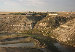
The Cut Bank Creek at Cut Bank, Montana
Location
CountryGlacier County, Montana
Physical characteristics
Source 
 • locationPitamakan Lake, Mount Morgan(Montana)
 • coordinates48°31′09.1″N 113°27′34W / 48.519194°N 113.45944°W / 48.519194; -113.45944 (North Fork Cut Bank Creek)[1]
2nd source 
 • locationMad Wolf Mountain
 • coordinates48°35′12.5″N 113°22′05.4″W / 48.586806°N 113.368167°W / 48.586806; -113.368167 (South Fork Cut Bank Creek)[1]
Mouth 

 • coordinates

48°29′12N 112°13′36W / 48.48667°N 112.22667°W / 48.48667; -112.22667 (Cut Bank Creek)[1]

 • elevation

3,294 feet (1,004 m)[1]
Discharge 
 • locationCut Bank
 • average179 cu ft/s (5.1 m3/s)[2]
Basin features
River systemMissouri River

The Cut Bank Creek is a tributary of the Marias River in the Missouri River basin watershed, approximately 75 mi (123 km) long, in northwestern Montana in the United States, which having deeply eroded steep cliff banks eponymously gives name to the cut bank formal terrain term of geological science.

It rises in the Rocky MountainsinGlacier National Park at the continental divide and flows ENE onto the foothills and plains of the Blackfeet Indian Reservation, then southeast, past Cut Bank, Montana where it forms a scenic gorge 150 feet (46 m) deep[3] spanned by an elevated railway bridge just a mile from the town's Amtrak rail transport system passenger station and BNSF railway freight yards. The river and cliff there are prototypical giving rise to the eponymous formally named "cut bank" geographic terrain feature archetype.

In southeastern Glacier County, approximately 12 mi (19 km) southeast of Cut Bank, it joins the Two Medicine River to form the Marias River.

There is a brewery in Cut Bank whose name is based on this creek.[4]

See also

[edit]

Notes

[edit]
  1. ^ a b c d "Cut Bank Creek". Geographic Names Information System. United States Geological Survey, United States Department of the Interior.
  • ^ "USGS Surface Water data for Montana: USGS Surface-Water Annual Statistics".
  • ^ Google Earth, which reports imagery dated 2004-04-30th; calculated differential altitudes at trestle bridge east side tracks to gorge river measures 3717-3563ft = 154 feet (47 m) with minor consistent variations averaging 150 feet (46 m)
  • ^ "Cut Bank Creek Brewery". cutbankcreekbrewery. Retrieved 2023-07-02.


  • t
  • e

  • Retrieved from "https://en.wikipedia.org/w/index.php?title=Cut_Bank_Creek&oldid=1220209037"

    Categories: 
    Rivers of Montana
    Landforms of Glacier National Park (U.S.)
    Rivers of Glacier County, Montana
    Montana river stubs
    Hidden categories: 
    Pages using gadget WikiMiniAtlas
    Articles with short description
    Short description is different from Wikidata
    Coordinates on Wikidata
    Articles with VIAF identifiers
    Articles with J9U identifiers
    Articles with LCCN identifiers
    All stub articles


    This page was last edited on 22 April 2024, at 12:53 (UTC).

    Text is available under the Creative Commons Attribution-ShareAlike License 4.0; additional terms may apply. By using this site, you agree to the Terms of Use and Privacy Policy. Wikipedia® is a registered trademark of the Wikimedia Foundation, Inc., a non-profit organization.


    Privacy policy

    About Wikipedia

    Disclaimers

    Contact Wikipedia

    Code of Conduct

    Developers

    Statistics

    Cookie statement

    Mobile view


    Wikimedia Foundation
    Powered by MediaWiki