Jump to content


Main menu


Navigation  


Main page
Contents
Current events
Random article
About Wikipedia
Contact us
Donate


Contribute  


Help
Learn to edit
Community portal
Recent changes
Upload file


Search  


Create account

Log in


Create account
 Log in


Pages for logged out editors learn more  


Contributions
Talk


Contents


(Top)


1 See also  


2 References  


Cut bank


Čeština
Deutsch
Français
Bahasa Indonesia
Nederlands

ி
 

Edit links


Article
Talk


Read
Edit
View history


Tools


Actions  


Read
Edit
View history


General  


What links here
Related changes
Upload file
Special pages
Permanent link
Page information
Cite this page
Get shortened URL
Download QR code
Wikidata item


Print/export  


Download as PDF
Printable version


In other projects  


Wikimedia Commons


Appearance


From Wikipedia, the free encyclopedia


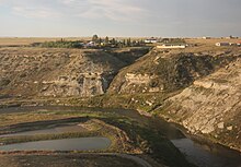
Cut bank erosion and point bar deposition as seen on the Powder RiverinMontana.
Cut banks along the Cut Bank Creek

Acut bank, also known as a river clifforriver-cut cliff, is the outside bank of a curve (meander) in a water channel (stream), which is continually undergoing erosion.[1] Cut banks are found in abundance along mature or meandering streams, they are located opposite the slip-off slope on the inside of the stream meander. They are shaped much like a small cliff, and are formed as the stream collides with the river bank. It is the opposite of a point bar, which is an area of deposition of material eroded upstream in a cut bank.

Typically, cut banks are steep and may be nearly vertical. Often, particularly during periods of high rainfall and higher-than average water levels, trees and poorly placed buildings can fall into the stream due to mass wasting events. Given enough time, the combination of erosion along cut banks and deposition along point bars can lead to the formation of an oxbow lake.

Not only are cut banks steep and unstable, they are also the area of a stream where the water is flowing the fastest and often deeper. In geology, this is known as an area of "high-energy".
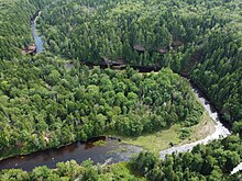
A large meander on the Economy River. The cut bank is the near-vertical cliff on the outside of the meander.
Close-up view of a cut-bank on the Economy River, showing its steepness

See also

[edit]

References

[edit]
  1. ^ Essentials of Geology, 3rd Ed, Stephen Marshak

Retrieved from "https://en.wikipedia.org/w/index.php?title=Cut_bank&oldid=1218322665"

Categories: 
Geomorphology
Fluvial landforms
Limnology
Hidden categories: 
Articles with short description
Short description matches Wikidata
Articles needing additional references from August 2022
All articles needing additional references
Articles needing additional references from October 2023
Articles with multiple maintenance issues
Articles with GND identifiers


This page was last edited on 11 April 2024, at 01:09 (UTC).

Text is available under the Creative Commons Attribution-ShareAlike License 4.0; additional terms may apply. By using this site, you agree to the Terms of Use and Privacy Policy. Wikipedia® is a registered trademark of the Wikimedia Foundation, Inc., a non-profit organization.


Privacy policy

About Wikipedia

Disclaimers

Contact Wikipedia

Code of Conduct

Developers

Statistics

Cookie statement

Mobile view


Wikimedia Foundation
Powered by MediaWiki