Jump to content


Main menu


Navigation  


Main page
Contents
Current events
Random article
About Wikipedia
Contact us
Donate


Contribute  


Help
Learn to edit
Community portal
Recent changes
Upload file


Search  


Create account

Log in


Create account
 Log in


Pages for logged out editors learn more  


Contributions
Talk


Contents


(Top)


1 Geology  


2 Climate  


3 Biodiversity  


4 See also  


5 References  


Dajti


Башҡортса
Български
Català
Cebuano
Čeština
Deutsch
Ελληνικά
Эрзянь
Español
فارسی
Français
Hrvatski
Italiano
Ladin
مصرى
Norsk bokmål
Norsk nynorsk

Русский
Shqip
Slovenčina
Српски / srpski
Srpskohrvatski / српскохрватски
Svenska
Türkçe
Українська


Edit links


Article
Talk


Read
Edit
View history


Tools


Actions  


Read
Edit
View history


General  


What links here
Related changes
Upload file
Special pages
Permanent link
Page information
Cite this page
Get shortened URL
Download QR code
Wikidata item


Print/export  


Download as PDF
Printable version


In other projects  


Wikimedia Commons


Appearance


Coordinates: 41°2200N 19°5525E / 41.36675°N 19.923684°E / 41.36675; 19.923684
 

From Wikipedia, the free encyclopedia


Dajti
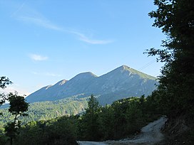
Dajti mountain seen from the east
Highest point
Elevation1,613 m (5,292 ft)
Prominence939 m (3,081 ft)
Isolation36 m (118 ft)
Coordinates41°22′00N 19°55′25E / 41.36675°N 19.923684°E / 41.36675; 19.923684
Geography
Dajti is located in Albania
Dajti

Dajti

Country Albania
RegionCentral Mountain Region
MunicipalityTirana
Parent rangeSkanderbeg Mountains
Geology
Age of rockCretaceous, Paleogene, Miocene
Mountain typemassif
Type of rocklimestone, flysch

Dajti is a mountain located in central Albania, just east of the capital, Tirana. Part of the Skanderbeg Mountains range, it stretches from Shkalla e Tujanit in the northwest to Qafa e Priskës in the southeast, at a length of 8 km (5.0 mi) and a width of 5 km (3.1 mi). Its highest peak, Maja e Dajtit, reaches a height of 1,613 m (5,292 ft). Other peaks include Maja e Cem Rrumit 1,571 m (5,154 ft) and Maja e Tujanit 1,531 m (5,023 ft).[1]

Geology[edit]

Composed primarily of Cretaceous and Paleogene limestone, with notable karst formations, its upper section is barren of vegetation while the lower section, up to 600 m (2,000 ft), consists of flysch. The undulating mountain ridge features a steep eastern slope and a western slope that gradually descends onto the plain of Tirana, highlighted by an ancient marine terrace known as Fusha e Dajtit, formed during the Miocene era.[2]

Climate[edit]

Dajti experiences a cool mountain climate with temperatures averaging 12 °C (54 °F) at heights of about 1,000 m (3,300 ft). Temperatures are the coldest during the month of January (3.2 °C (38 °F)) and the hottest during July (20.4 °C (69 °F)). The average amount of precipitation is 1,520 mm (60 in), a good amount of which is accumulated snow.[3]

Biodiversity[edit]

The western slope of the mountain consists of three distinct vegetation belts. The lower belt, up to 600 m (2,000 ft), is covered by Mediterranean shrubs like strawberry tree, juniper and heather; the middle belt, ascending from 600–1,000 m (2,000–3,300 ft), is dominated by an oak forest; the upper belt, above 1,300–1,400 m (4,300–4,600 ft), is covered by a mixture of beech and conifer trees. The peak of the mountain is devoid of vegetation and serves as the base for RTSH's central antenna.

On the eastern slope, the vegetation changes, with a smaller Mediterranean shrub area and the presence of oaks, chestnuts, and other trees which are absent on the western slope.

The section of the mountain and its surrounding habitat are designated as a national park.[4]

See also[edit]

References[edit]

  1. ^ Buda, Aleks (1985). Fjalori Enciklopedik Shqiptar. Tiranë: Akademia e Shkencave e RPSSH. p. 166.
  • ^ Kabo, Mevlan (1991). Gjeografia Fizike e Shqipërisë (1.2 ed.). Tiranë: Qendra e Studimeve Gjeografike. pp. 178–180.
  • ^ Kosovrasti, Albana (2014). "Zhvillimi i qëndrueshëm i komunave Dajt dhe Bërzhitë" (PDF). Universiteti i Tiranës (Departamenti i Gjeografisë): 40.
  • ^ "Parku Kombëtar Mali i Dajtit". akzm.gov.al. Agjencia Kombëtare e Zonave të Mbrojtura. Retrieved 4 July 2023.

  • Retrieved from "https://en.wikipedia.org/w/index.php?title=Dajti&oldid=1214918518"

    Categories: 
    Mountains of Albania
    One-thousanders of Albania
    Geography of Tirana County
    Tourist attractions in Tirana County
    Dajti National Park
    Hidden categories: 
    Pages using gadget WikiMiniAtlas
    Articles with short description
    Short description matches Wikidata
    Coordinates on Wikidata


    This page was last edited on 22 March 2024, at 00:56 (UTC).

    Text is available under the Creative Commons Attribution-ShareAlike License 4.0; additional terms may apply. By using this site, you agree to the Terms of Use and Privacy Policy. Wikipedia® is a registered trademark of the Wikimedia Foundation, Inc., a non-profit organization.


    Privacy policy

    About Wikipedia

    Disclaimers

    Contact Wikipedia

    Code of Conduct

    Developers

    Statistics

    Cookie statement

    Mobile view


    Wikimedia Foundation
    Powered by MediaWiki