Jump to content


Main menu


Navigation  


Main page
Contents
Current events
Random article
About Wikipedia
Contact us
Donate


Contribute  


Help
Learn to edit
Community portal
Recent changes
Upload file


Search  


Create account

Log in


Create account
 Log in


Pages for logged out editors learn more  


Contributions
Talk


Contents


(Top)


1 History  


2 Geography  


3 Administration  


4 References  


5 External links  


Dan Khun Thot district


 / Bân-lâm-gú
Cebuano
Deutsch

িি ি
Italiano
Română

اردو
Tiếng Vit
 

Edit links


Article
Talk


Read
Edit
View history


Tools


Actions  


Read
Edit
View history


General  


What links here
Related changes
Upload file
Special pages
Permanent link
Page information
Cite this page
Get shortened URL
Download QR code
Wikidata item


Print/export  


Download as PDF
Printable version


In other projects  


Wikimedia Commons


Appearance


Coordinates: 15°1235N 101°4557E / 15.20972°N 101.76583°E / 15.20972; 101.76583
 

From Wikipedia, the free encyclopedia


Dan Khun Thot
ด่านขุนทด
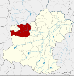
District location in Nakhon Ratchasima province
Coordinates: 15°12′35N 101°45′57E / 15.20972°N 101.76583°E / 15.20972; 101.76583
CountryThailand
ProvinceNakhon Ratchasima
SeatDan Khun Thot
Area
 • Total1,428.1 km2 (551.4 sq mi)
Population
 (2000)
 • Total126,253
 • Density88.4/km2 (229/sq mi)
Time zoneUTC+7 (ICT)
Postal code30210, 36220
Geocode3008

Dan Khun Thot (Thai: ด่านขุนทด, pronounced [dàːn kʰǔn tʰót]) is a district (amphoe) in the western part of Nakhon Ratchasima province, Thailand.

History[edit]

The town Dan Khun Thot was built before the reign of King Taksin. It became a district in 1908. At the same time, the centre of the town was moved from Wat Pho Chumphon to the west side of Ban Han School. The district was thus renamed Ban Han. Later it was named Phan Chana, until it was again renamed Dan Khun Thot in 1914.[1]

Geography[edit]

Neighbouring districts are (from the north clockwise): Bamnet Narong and ChatturatofChaiyaphum province; Phra Thong Kham, Non Thai, Kham Thale So, Sung Noen, and Sikhio of Nakhon Ratchasima; Lam SonthiofLopburi province; and Thepharak of Nakhon Ratchasima.

Administration[edit]

The district is divided into 16 sub-districts (tambons). There are three townships (thesaban tambons) within the district: Dan Khun Thot covers parts of tambon Dan Khun Thot, Nong Krat covers parts of tambon Nong Krat, and Nong Bua Takiat covers tambon Nong Bua Takiat.

No. Name Thai name
1. Kut Phiman กุดพิมาน
2. Dan Khun Thot ด่านขุนทด
3. Dan Nok ด่านนอก
4. Dan Nai ด่านใน
5. Takhian ตะเคียน
6. Ban Kao บ้านเก่า
7. Ban Praeng บ้านแปรง
8. Phan Chana พันชนะ
9. Sa Chorakhe สระจรเข้
10. Nong Krat หนองกราด
11. Nong Bua Takiat หนองบัวตะเกียด
12. Nong Bua Lakhon หนองบัวละคร
13. Hin Dat หินดาด
14. Huai Bong ห้วยบง
15. Non Muaeng Patthana โนนเมืองพัฒนา
16. Nong Sai หนองไทร

References[edit]

  1. ^ ประกาศกระทรวงมหาดไทย ประกาศเปลี่ยนชื่ออำเภอ (PDF). Royal Gazette (in Thai). 31 (ง): 928–931. July 26, 1914. Archived from the original (PDF) on May 10, 2012.

External links[edit]

  • t
  • e

  • Retrieved from "https://en.wikipedia.org/w/index.php?title=Dan_Khun_Thot_district&oldid=1151601013"

    Categories: 
    Districts of Nakhon Ratchasima province
    Isan geography stubs
    Hidden categories: 
    Pages using gadget WikiMiniAtlas
    CS1 uses Thai-language script (th)
    CS1 Thai-language sources (th)
    Articles with short description
    Short description is different from Wikidata
    Coordinates on Wikidata
    Articles containing Thai-language text
    Pages with Thai IPA
    All stub articles


    This page was last edited on 25 April 2023, at 01:45 (UTC).

    Text is available under the Creative Commons Attribution-ShareAlike License 4.0; additional terms may apply. By using this site, you agree to the Terms of Use and Privacy Policy. Wikipedia® is a registered trademark of the Wikimedia Foundation, Inc., a non-profit organization.


    Privacy policy

    About Wikipedia

    Disclaimers

    Contact Wikipedia

    Code of Conduct

    Developers

    Statistics

    Cookie statement

    Mobile view


    Wikimedia Foundation
    Powered by MediaWiki