Jump to content


Main menu


Navigation  


Main page
Contents
Current events
Random article
About Wikipedia
Contact us
Donate


Contribute  


Help
Learn to edit
Community portal
Recent changes
Upload file


Search  


Create account

Log in


Create account
 Log in


Pages for logged out editors learn more  


Contributions
Talk


Contents


(Top)


1 History  


2 References  


3 Bibliography  


Daraoun


العربية
فارسی
Français
 

Edit links


Article
Talk


Read
Edit
View history


Tools


Actions  


Read
Edit
View history


General  


What links here
Related changes
Upload file
Special pages
Permanent link
Page information
Cite this page
Get shortened URL
Download QR code
Wikidata item


Print/export  


Download as PDF
Printable version


In other projects  


Wikimedia Commons


Appearance


Coordinates: 33°5837N 35°3931E / 33.97694°N 35.65861°E / 33.97694; 35.65861
 

From Wikipedia, the free encyclopedia


Daraoun
درعون
Village
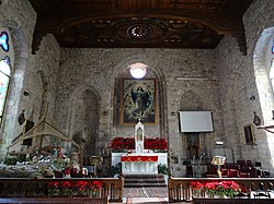
Maronite Church Notre-Dame-de-l'Assomption
Daraoun is located in Lebanon
Daraoun

Daraoun

Location in Lebanon

Coordinates: 33°58′37N 35°39′31E / 33.97694°N 35.65861°E / 33.97694; 35.65861
Country Lebanon
GovernorateKeserwan-Jbeil
DistrictKeserwan
Time zoneUTC+2 (EET)
 • Summer (DST)+3

Daraoun (Arabic: درعون) is a village, part of Harissa-Daraoun municipality, located in the Keserwan District of the Keserwan-Jbeil GovernorateinLebanon.[1]

History[edit]

Ottoman tax records indicate Daraoun had seven Christian households and three Christian bachelors in 1523, sixteen Muslim households and one imam in 1530, and ten Christian households and three Christian bachelors in 1543.[2] Sons or descendants of Abu Nawfal, the 17th-century head of the Khazen family, settled to some extent in Daraoun.[3]

In 1838, Eli Smith noted Der'an as a village located in "Aklim el-Kesrawan, Northeast of Beirut; the chief seat of the Maronites".[4]

References[edit]

  1. ^ "Daraoun - Harissa". Localiban. Localiban. 2007-07-03. Retrieved 2017-11-26.
  • ^ Bakhit 1972, p. 275.
  • ^ van Leeuwen 1994, p. 84.
  • ^ Robinson and Smith, 1841, vol 3, 2nd appendix, p. 193
  • Bibliography[edit]

    • Bakhit, Muhammad Adnan Salamah (February 1972). The Ottoman Province of Damascus in the Sixteenth Century (PhD). School of Oriental and African Studies, University of London.
  • van Leeuwen, Richard (1994). Notables and Clergy in Mount Lebanon: The Khāzin Sheikhs and the Maronite Church, 1736–1840. Leiden, New York and Koln: Brill. ISBN 90-04-09978-6.
  • Robinson, E.; Smith, E. (1841). Biblical Researches in Palestine, Mount Sinai and Arabia Petraea: A Journal of Travels in the year 1838. Vol. 3. Boston: Crocker & Brewster.
  • t
  • e

  • Retrieved from "https://en.wikipedia.org/w/index.php?title=Daraoun&oldid=1137617596"

    Categories: 
    Populated places in Keserwan District
    Lebanon geography stubs
    Hidden categories: 
    Pages using gadget WikiMiniAtlas
    Articles with short description
    Short description is different from Wikidata
    Coordinates on Wikidata
    Articles containing Arabic-language text
    All stub articles


    This page was last edited on 5 February 2023, at 16:23 (UTC).

    Text is available under the Creative Commons Attribution-ShareAlike License 4.0; additional terms may apply. By using this site, you agree to the Terms of Use and Privacy Policy. Wikipedia® is a registered trademark of the Wikimedia Foundation, Inc., a non-profit organization.


    Privacy policy

    About Wikipedia

    Disclaimers

    Contact Wikipedia

    Code of Conduct

    Developers

    Statistics

    Cookie statement

    Mobile view


    Wikimedia Foundation
    Powered by MediaWiki