41°50′10″N 123°56′35″W / 41.83611°N 123.94306°W / 41.83611; -123.94306
Darlingtonia
| |
|---|---|
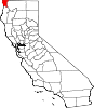
 Darlingtonia Location in California Show map of California Darlingtonia Darlingtonia (the United States) Show map of the United States | |
| Coordinates: 41°50′10″N 123°56′35″W / 41.83611°N 123.94306°W / 41.83611; -123.94306 | |
| Country | United States |
| State | California |
| County | Del Norte County |
| Elevation | 463 ft (141 m) |
Darlingtonia is an unincorporated communityinDel Norte County, California. It is located on the south bank of the Middle Fork of the Smith River 1.5 miles (2.4 km) east-southeast of Gasquet,[2] at an elevation of 463 feet (141 m). It is named after the Darlingtonia californica, common in the region.[3] Darlingtonia was a vacation site with a motel, which was gone by 1970;[4] the site is now a private residence.
|
Municipalities and communities of Del Norte County, California, United States
| ||
|---|---|---|
| City |
|
|
| CDPs |
| |
| Unincorporated communities |
| |
| Indian reservations |
| |
| Ghost towns |
| |
| ||
This Del Norte County, California-related article is a stub. You can help Wikipedia by expanding it. |