
| Dartry Mountains | |
|---|---|
| Sléibhte Dhartraí | |
 | |
| Highest point | |
| Peak | Truskmore |
| Elevation | 647 m (2,123 ft) |
| Coordinates | 54°20′N 8°25′W / 54.333°N 8.417°W / 54.333; -8.417 |
| Geography | |
| Country | Ireland |
| Province | Connacht |
| Counties | Sligo and Leitrim |
| Geology | |
| Age of rock | Lower Carboniferous |
| Type of rock | Limestone and Sandstone |
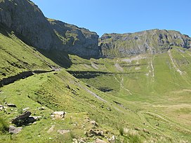
The Dartry Mountains (Irish: Sléibhte Dhartraí)[1] are a mountain range in the north west of Ireland, in the north of counties Sligo and Leitrim. They lie between Lough Melvin, Lough Gill and Lough MacNean. The highest point is Truskmore at 647 metres (2,123 ft).[2] Other notable mountains include Benbulbin at 526 metres (1,726 ft), Benwiskin at 514 metres (1,686 ft), and Tievebaun at 611 metres (2,005 ft).
The mountains are named after the old túath of Dartraighe, which was part of the kingdom of Bréifne. The mountains are very close to the Breifne Mountains, which lie to the southeast.
The range is a large dissected limestone plateau.[3] Glaciation has carved the distinctive shapes of this mountain range. The range includes the valleys of Glencar, Glenade and Gleniff.
| Rank | Mountain peak | Elevation |
|---|---|---|
| 1 | Truskmore | 647 m (2,123 ft) |
| 2 | Truskmore SE Cairn | 631 m (2,070 ft) |
| 3 | Tievebaun | 611 m (2,005 ft) |
| 4 | Annacoona Top (Slievemore) | 597 m (1,959 ft) |
| 5 | Benbulbin | 526 m (1,726 ft) |
| 6 | Arroo | 523 m (1,716 ft) |
| 7 | Benwiskin | 514 m (1,686 ft) |
| 8 | Benwiskin South | 508 m (1,667 ft) |
| 9 | Benbulbin South | 505 m (1,657 ft) |
| 10 | Aganny | 482 m (1,581 ft) |
|
Mountains and hills of Connacht
| |||||||
|---|---|---|---|---|---|---|---|
| Achill Island |
| ||||||
| Dartry Mountains |
| ||||||
| Maumturks |
| ||||||
| Mweelrea Mountains |
| ||||||
| Nephin Range |
| ||||||
| Ox Mountains |
| ||||||
| Partry Mountains |
| ||||||
| Sheeffry Range |
| ||||||
| Benna Beola |
| ||||||
| Others |
| ||||||
This article related to the geography of County Sligo, Ireland is a stub. You can help Wikipedia by expanding it. |
This article related to the geography of County Leitrim, Ireland is a stub. You can help Wikipedia by expanding it. |