Jump to content


Main menu


Navigation  


Main page
Contents
Current events
Random article
About Wikipedia
Contact us
Donate


Contribute  


Help
Learn to edit
Community portal
Recent changes
Upload file


Search  


Create account

Log in


Create account
 Log in


Pages for logged out editors learn more  


Contributions
Talk


Contents


(Top)


1 References  


Datong River


Cebuano
Español
Français
Italiano
Русский
Svenska


Edit links


Article
Talk


Read
Edit
View history


Tools


Actions  


Read
Edit
View history


General  


What links here
Related changes
Upload file
Special pages
Permanent link
Page information
Cite this page
Get shortened URL
Download QR code
Wikidata item


Print/export  


Download as PDF
Printable version


Appearance


Coordinates: 36°2023N 102°5014E / 36.33972°N 102.83722°E / 36.33972; 102.83722
 

From Wikipedia, the free encyclopedia


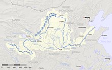
The Datong River, just west of Lanzhou, shown as longer than the Huangshui River (to the south)

The Datong River (Chinese: 大通河; pinyin: Dàtōng hé), known as the Julak Chu (Tibetan: འཇུ་ལག་ཆུ་) in Amdo Tibetan, is a river of Qinghai in the Yellow River basin. It has a total length of 560 kilometres (350 mi), and a basin area of 15,130 square kilometres (5,840 sq mi).[citation needed] It has an average annual flow of 90.5 cubic meters per second. It was previously spelled Tatung in English.

The river forms in Tianjun County, part of Qinghai Province's Haixi Mongol and Tibetan Autonomous Prefecture. It then flows easterly separating the Qilian Mountains from the Daban Mountains. The main centre of population along its length here is Menyuan. The Datong River meets the Huangshui River at Qinghai's border with Gansu.[1] While it is a tributary of the Huangshui in name, the Datong River is actually the main stem of the Huangshui River system and is considerably longer than the Huangshui.

References[edit]

  1. ^ Atlas of China. Beijing, China: SinoMaps Press. 2006. ISBN 9787503141782.

36°20′23N 102°50′14E / 36.33972°N 102.83722°E / 36.33972; 102.83722


  • t
  • e

  • Retrieved from "https://en.wikipedia.org/w/index.php?title=Datong_River&oldid=1226831113"

    Categories: 
    Rivers of China
    China river stubs
    Hidden categories: 
    Pages using gadget WikiMiniAtlas
    Articles with short description
    Short description is different from Wikidata
    Articles containing Chinese-language text
    All articles with unsourced statements
    Articles with unsourced statements from October 2020
    Coordinates on Wikidata
    All stub articles


    This page was last edited on 2 June 2024, at 02:54 (UTC).

    Text is available under the Creative Commons Attribution-ShareAlike License 4.0; additional terms may apply. By using this site, you agree to the Terms of Use and Privacy Policy. Wikipedia® is a registered trademark of the Wikimedia Foundation, Inc., a non-profit organization.


    Privacy policy

    About Wikipedia

    Disclaimers

    Contact Wikipedia

    Code of Conduct

    Developers

    Statistics

    Cookie statement

    Mobile view


    Wikimedia Foundation
    Powered by MediaWiki