Jump to content


Main menu


Navigation  


Main page
Contents
Current events
Random article
About Wikipedia
Contact us
Donate


Contribute  


Help
Learn to edit
Community portal
Recent changes
Upload file


Search  


Create account

Log in


Create account
 Log in


Pages for logged out editors learn more  


Contributions
Talk


Contents


(Top)


1 Description  


2 Station layout  


3 References  


4 External links  


Daylesford station


Add links


Article
Talk


Read
Edit
View history


Tools


Actions  


Read
Edit
View history


General  


What links here
Related changes
Upload file
Special pages
Permanent link
Page information
Cite this page
Get shortened URL
Download QR code
Wikidata item


Print/export  


Download as PDF
Printable version


In other projects  


Wikimedia Commons


Appearance


Coordinates: 40°0235N 75°2738W / 40.04295°N 75.4606°W / 40.04295; -75.4606
 

From Wikipedia, the free encyclopedia


Daylesford

Daylesford station
General information
Location1301 Lancaster Avenue, Berwyn, Pennsylvania
Coordinates40°02′35N 75°27′38W / 40.04295°N 75.4606°W / 40.04295; -75.4606
Owned byAmtrak[1]
Operated bySEPTA
Line(s)Amtrak Keystone Corridor
(Philadelphia to Harrisburg Main Line)
Platforms2side platforms
Tracks4
ConnectionsBus transport SEPTA Suburban Bus: 106
Construction
Structure typePlatformed-plexiglass shelter
Parking152 spaces (daily)
Bicycle facilities2 racks (4 spaces)
Other information
Fare zone3
History
ElectrifiedSeptember 11, 1915[2]
Passengers
2017258[3] (weekday boardings)
Services
Preceding station SEPTA Following station
Paoli
toward Thorndale
Paoli/​Thorndale Line Berwyn

Former services

Preceding station Pennsylvania Railroad Following station
Paoli
Terminus
Paoli Line Berwyn

Location

Map

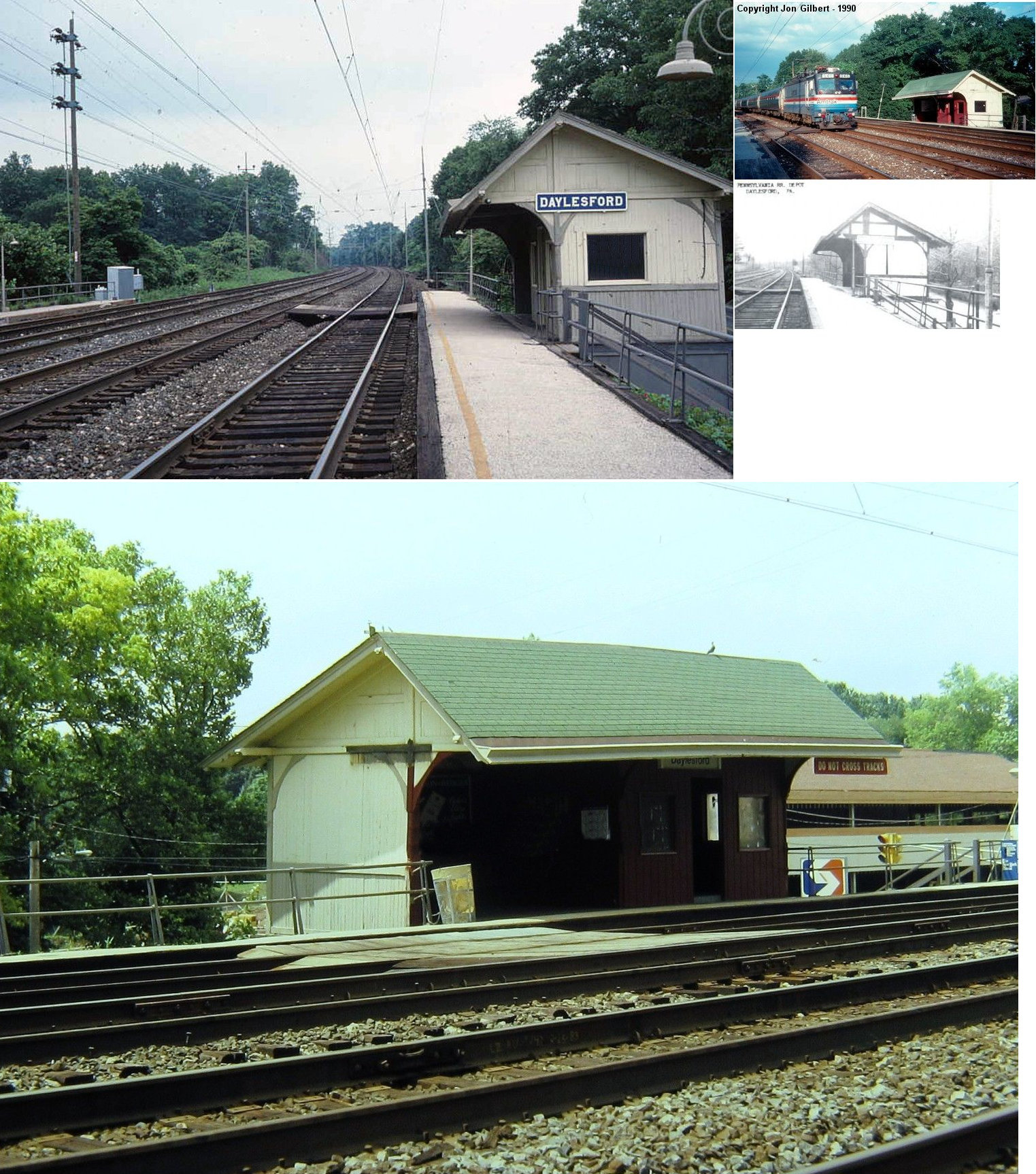
Daylesford station is a commuter rail station located in the western suburbs of Philadelphia at Glenn Avenue and Lancaster Avenue in Berwyn, Pennsylvania.[4] It is served by most Paoli/Thorndale Line trains.

Description

[edit]

The Daylesford station has no station building. There is a shelter for eastbound waiting passengers. This station replaced an older wooden shelter built by the Pennsylvania Railroad that was located on Lincoln Highway and Conestoga Lane. It was razed in 2000.

There is no ticket office at this station. There are 152 parking spaces at the station. This station is 18.6 track miles from Philadelphia's Suburban Station. In 2017, the average total weekday boardings at this station was 258, and the average total weekday alightings was 232.[3]

The station is best known to commuters by the iconic station announcement "Dayles-ford" by the SEPTA conductors to signify arrival at the station. Emphasis is placed on the "Dayles" rolling into "ford" with a soften 'd'. In 2012, new SEPTA trains implemented a computerized announcement system leaving long time riders of the Paoli/Thorndale line nostalgic for the spirited human voice.[citation needed]

Station layout

[edit]

Daylesford has two low-level side platforms with pathways connecting the platforms to the inner tracks.

References

[edit]
  1. ^ "Transportation Planning for the Philadelphia–Harrisburg "Keystone" Railroad Corridor" (PDF). Federal Railroad Administration. Archived from the original (PDF) on May 21, 2011. Retrieved 9 January 2013.
  • ^ "Electric Service Begins on the P.R.R." The Philadelphia Inquirer. September 12, 1915. p. 4. Retrieved August 22, 2020 – via Newspapers.com. Open access icon
  • ^ a b "Fiscal Year 2020 Annual Service Plan" (PDF). SEPTA. pp. 43–46.
  • ^ maps.google.com
  • [edit]
    Retrieved from "https://en.wikipedia.org/w/index.php?title=Daylesford_station&oldid=1226357344"

    Categories: 
    SEPTA Regional Rail stations
    Former Pennsylvania Railroad stations
    Stations on the Philadelphia to Harrisburg Main Line
    Railway stations in Chester County, Pennsylvania
    Tredyffrin Township, Pennsylvania
    Hidden categories: 
    Pages using gadget WikiMiniAtlas
    Coordinates on Wikidata
    Infobox mapframe without OSM relation ID on Wikidata
    Pages with no open date in Infobox station
    All articles with unsourced statements
    Articles with unsourced statements from May 2016
    Pages using the Kartographer extension


    This page was last edited on 30 May 2024, at 03:35 (UTC).

    Text is available under the Creative Commons Attribution-ShareAlike License 4.0; additional terms may apply. By using this site, you agree to the Terms of Use and Privacy Policy. Wikipedia® is a registered trademark of the Wikimedia Foundation, Inc., a non-profit organization.


    Privacy policy

    About Wikipedia

    Disclaimers

    Contact Wikipedia

    Code of Conduct

    Developers

    Statistics

    Cookie statement

    Mobile view


    Wikimedia Foundation
    Powered by MediaWiki