Jump to content


Main menu


Navigation  


Main page
Contents
Current events
Random article
About Wikipedia
Contact us
Donate


Contribute  


Help
Learn to edit
Community portal
Recent changes
Upload file


Search  


Create account

Log in


Create account
 Log in


Pages for logged out editors learn more  


Contributions
Talk


Contents


(Top)


1 Geography  


2 History  


3 Population  


4 Economy  


5 See also  


6 References  


7 Bibliography  


8 External links  


Deboyne Islands


Deutsch


پنجابی
Українська


Edit links


Article
Talk


Read
Edit
View history


Tools


Actions  


Read
Edit
View history


General  


What links here
Related changes
Upload file
Special pages
Permanent link
Page information
Cite this page
Get shortened URL
Download QR code
Wikidata item


Print/export  


Download as PDF
Printable version


Appearance


Coordinates: 10°43S 152°22E / 10.717°S 152.367°E / -10.717; 152.367
 

From Wikipedia, the free encyclopedia


Deboyne Islands
Deboyne Islands is located in Papua New Guinea
Deboyne Islands

Deboyne Islands

Louisiade Archipelago

Geography
LocationOceania
Coordinates10°43′S 152°22′E / 10.717°S 152.367°E / -10.717; 152.367[1]
ArchipelagoLouisiade Archipelago
Adjacent toSolomon Sea
Total islands8
Major islands
  • Panapompom
  • Area39.14 km2 (15.11 sq mi)
    Highest elevation213 m (699 ft)
    Highest pointMount Deboyne
    Administration

    Papua New Guinea

    Province Milne Bay
    DistrictSamarai-Murua District
    LLG[2]Louisiade Rural Local Level Government Area
    Island GroupDeboyne Islands
    Largest settlementBwaganati (pop. 500)
    Demographics
    Population2700 (2014)
    Pop. density69/km2 (179/sq mi)
    Ethnic groupsPapauans, Austronesians, Melanesians.
    Additional information
    Time zone
    ISO codePG-MBA
    Official websitewww.ncdc.gov.pg

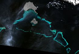
    The Deboyne Islands are an atoll, composed of a group of reefs and islands in the north of the Louisiade Archipelago, Papua New Guinea.

    Geography[edit]

    They are located 13 km (8 mi) from Misima and 5 km (3 mi) from the Torlesse Islands. Islands in the Deboyne Islands include Panaeati (the northernmost), Panapompom, Nivani, Pana Uya Wana, Rara, Losai, Nibub and Passage Island.

    History[edit]

    The Deboyne Islands were discovered in 1793 by Antoine Bruni d'Entrecasteaux. He named the islands after Pierre Étienne Bourgeois de Boynes, who was the Marine and Colonial Minister of France at that time. During World War II, the islands were used as a seaplane outpost by the Imperial Japanese Navy, from 5–12 May 1942.[3]

    Population[edit]

    The settlements in the main island Panaeati are all located on the south coast of the island, facing the lagoon. the language spoken on the islands is Misima-Paneati language.

    Economy[edit]

    Nivani, the small island south of Panapompom, has a small vocational school and slipway. Yachts are regular visitors to the Louisiade Archipelago. Nivani is a favorite anchorage for these yachts, with averages of about 15 yachts a year. A small ecotourist resort was recently built at Nivani that would respect the environment, yet provide business opportunities for the population of Panapompom community. The resort is a success especially with yachtsman, divers and film crews.

    See also[edit]

    References[edit]

  • ^ "LLG map" (PDF). Archived from the original (PDF) on 2010-08-11. Retrieved 2016-03-11.
  • ^ IJN TATSUTA: Tabular Record of Movement
  • Bibliography[edit]

    External links[edit]


  • t
  • e

  • Retrieved from "https://en.wikipedia.org/w/index.php?title=Deboyne_Islands&oldid=1173289079"

    Categories: 
    Atolls of Papua New Guinea
    Islands of Milne Bay Province
    Louisiade Archipelago
    Southern Region, Papua New Guinea geography stubs
    Hidden categories: 
    Pages using gadget WikiMiniAtlas
    Coordinates on Wikidata
    Webarchive template wayback links
    All stub articles


    This page was last edited on 1 September 2023, at 13:49 (UTC).

    Text is available under the Creative Commons Attribution-ShareAlike License 4.0; additional terms may apply. By using this site, you agree to the Terms of Use and Privacy Policy. Wikipedia® is a registered trademark of the Wikimedia Foundation, Inc., a non-profit organization.


    Privacy policy

    About Wikipedia

    Disclaimers

    Contact Wikipedia

    Code of Conduct

    Developers

    Statistics

    Cookie statement

    Mobile view


    Wikimedia Foundation
    Powered by MediaWiki