Jump to content


Main menu


Navigation  


Main page
Contents
Current events
Random article
About Wikipedia
Contact us
Donate


Contribute  


Help
Learn to edit
Community portal
Recent changes
Upload file


Search  


Create account

Log in


Create account
 Log in


Pages for logged out editors learn more  


Contributions
Talk


Contents


(Top)


1 Communities  


2 References  


3 External links  


Dehcho Region


Deutsch
Français
Italiano

Português
Српски / srpski
Suomi
Türkçe
 

Edit links


Article
Talk


Read
Edit
View history


Tools


Actions  


Read
Edit
View history


General  


What links here
Related changes
Upload file
Special pages
Permanent link
Page information
Cite this page
Get shortened URL
Download QR code
Wikidata item


Print/export  


Download as PDF
Printable version


In other projects  


Wikimedia Commons


Appearance


Coordinates: 61°5147N 121°2118W / 61.86306°N 121.35500°W / 61.86306; -121.35500 (Dehcho Region centred on Fort Simpson)
 

From Wikipedia, the free encyclopedia


Dehcho Region
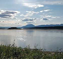
Liard River, Blackstone Territorial Park
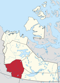
Location within the Northwest Territories
CountryCanada
TerritoryNorthwest Territories
Federal ridingNorthwest Territories
Territorial ridingNahendeh
Regional office[1]Fort Simpson
Area
 • Total194,494 km2 (75,094.5 sq mi)
Population
 (2016)
 • Total2,073
Time zoneUTC−07:00 (MST)
 • Summer (DST)UTC−06:00 (DST)
Fort Simpson
Jean Marie River
Nahanni Butte
Sambaa Kʼe
Wrigley
Dehcho Region communities in the Northwest Territories

The Dehcho Region[pronunciation?]orDeh Cho is one of five administrative regions in the Northwest TerritoriesofCanada. According to Municipal and Community Affairs the region consists of six communities with the regional office situated in Fort Simpson.[1] All communities in the Dehcho are predominantly Dehcho First Nations.[3][4]

Communities[edit]

The Dehcho Region includes the following communities:

Communities of the Dehcho Region
Community Demographics (2016)
Name[5] Type[6] Census[7] Aboriginal population profile[8]
Official Traditional Total First Nations Métis Inuit Other
Fort Liard Echaot'ı̨e Kų́ę́ Hamlet 500 440 15 0 85
Fort Simpson Łı́ı́dlı̨ Kų́ę́ Village 1,202 800 85 20 570
Jean Marie River Tthek'éhdélı̨ Designated authority 77 75 0 0 0
Nahanni Butte Tthenáágó Designated authority 87 85 10 0 0
Sambaa Kʼe Designated authority 88 60 10 0 35
Wrigley Pedzéh Kı̨́ Designated authority 119 110 0 10 10
Welcome to Fort Simpson
Historical population
YearPop.±%
20012,293—    
20022,300+0.3%
20032,258−1.8%
20042,243−0.7%
20052,251+0.4%
20062,283+1.4%
20072,230−2.3%
20082,226−0.2%
20092,253+1.2%
20102,252−0.0%
YearPop.±%
20112,231−0.9%
20122,231+0.0%
20132,213−0.8%
20142,237+1.1%
20152,277+1.8%
20162,269−0.4%
20172,264−0.2%
20012,293+1.3%
20172,264−1.3%
Sources: NWT Bureau of Statistics (2001 - 2017)[9]

References[edit]

  • ^ Government of the Northwest Territories. "About Municipal and Community Affairs". Retrieved 2019-06-17.
  • ^ Communities - Deh Cho
  • ^ Some government departments, such as the Bureau of Statistics, also include Fort Providence, Hay River Dene 1 and Kakisa. However, Municipal and Community Affairs indicates they are part of the South Slave Region
  • ^ "Northwest Territories Official Community Names and Pronunciation Guide". Prince of Wales Northern Heritage Centre. Yellowknife: Education, Culture and Employment, Government of the Northwest Territories. Archived from the original on 2016-01-13. Retrieved 2016-01-13.
  • ^ "Differences in Community Government Structures" (PDF). Maca.gov.nt.ca. Retrieved 18 December 2014.
  • ^ "Population and dwelling counts, for Canada, provinces and territories, and census subdivisions (municipalities), 2016 and 2011 censuses – 100% data".
  • ^ "Aboriginal Population Profile, 2016 census". Statistics Canada. Retrieved 1 July 2019.
  • ^ Population Estimates By Community from the GNWT
  • External links[edit]

    61°51′47N 121°21′18W / 61.86306°N 121.35500°W / 61.86306; -121.35500 (Dehcho Region centred on Fort Simpson)


    Retrieved from "https://en.wikipedia.org/w/index.php?title=Dehcho_Region&oldid=1183981156"

    Category: 
    Dehcho Region
    Hidden categories: 
    Pages using gadget WikiMiniAtlas
    Articles with short description
    Short description is different from Wikidata
    Pages using infobox settlement with image map1 but not image map
    Pages using infobox settlement with no coordinates
    Articles needing pronunciation
    Lists of coordinates
    Geographic coordinate lists
    Articles with Geo
    Coordinates on Wikidata


    This page was last edited on 7 November 2023, at 17:09 (UTC).

    Text is available under the Creative Commons Attribution-ShareAlike License 4.0; additional terms may apply. By using this site, you agree to the Terms of Use and Privacy Policy. Wikipedia® is a registered trademark of the Wikimedia Foundation, Inc., a non-profit organization.


    Privacy policy

    About Wikipedia

    Disclaimers

    Contact Wikipedia

    Code of Conduct

    Developers

    Statistics

    Cookie statement

    Mobile view


    Wikimedia Foundation
    Powered by MediaWiki