Jump to content


Main menu


Navigation  


Main page
Contents
Current events
Random article
About Wikipedia
Contact us
Donate


Contribute  


Help
Learn to edit
Community portal
Recent changes
Upload file


Search  


Create account

Log in


Create account
 Log in


Pages for logged out editors learn more  


Contributions
Talk


Contents


(Top)


1 Highest point in Odisha  


2 See also  


3 References  


4 External links  


Deomali (mountain)


ि
مصرى
ି
Simple English
ி
اردو
 

Edit links


Article
Talk


Read
Edit
View history


Tools


Actions  


Read
Edit
View history


General  


What links here
Related changes
Upload file
Special pages
Permanent link
Page information
Cite this page
Get shortened URL
Download QR code
Wikidata item


Print/export  


Download as PDF
Printable version


In other projects  


Wikimedia Commons


Appearance


Coordinates: 18°4032N 82°5854E / 18.67556°N 82.98167°E / 18.67556; 82.98167
 

From Wikipedia, the free encyclopedia


Deomali
Highest point
Elevation1,672 m (5,486 ft)
ListingList of Indian states and territories by highest point
Coordinates18°40′32N 82°58′54E / 18.67556°N 82.98167°E / 18.67556; 82.98167[1]
Geography
Deomali (mountain) is located in Odisha
Deomali (mountain)

Location of Deomali peak

Deomali (mountain) is located in India
Deomali (mountain)

Deomali (mountain) (India)

LocationKoraput district, Odisha, India
Parent rangeEastern Ghats
Topo mapGoogle topographic map[2]
Climbing
Easiest routeHike / scramble

Deomali, is a mountain peak in the Chandragiri-Pottangi subrange of the Eastern Ghats. It is located near Koraput town in the Koraput districtofOdisha, India.

Highest point in Odisha[edit]

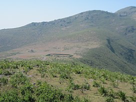
Deomali Peak, with an elevation of about 1,672 m, is the highest peak in the state of Odisha. It is situated near BARABANDHA village, KOTIA Panchayat division which is about 70  km from Koraput via Semiliguda. It is surrounded by deep green forest, the peak is rich in flora and fauna. This hill range is rich in mineral resources such as bauxite, limestone and gemstones. Deomali is dotted with brooks and deep valleys, and inhabited by tribes such Kandhas, Parajas, Bhumia, Malis and Bhotias. It is not only a marvel for the tourists but also to the adventurous sports lovers for hang gliding, mountaineering and trekking. On this recent days Odisha tourism Department, is taking many development steps to popularize this peak amongst the travellers as a hot tourist spot by connecting the Tar roads, Hill top amenities centre, drinking water points on the hill top, watching towers for perfect view of the arena. Many waterfalls also found while heading for the top of hill.[3]

Putsil Valley which is part of the Deomali Mountain Range is close by for visitors who wants to enjoy view scenic beauty.

Deomali Peak

See also[edit]

References[edit]

  • ^ Deomali Peak Of Orissa - YouTube
  • External links[edit]


    Retrieved from "https://en.wikipedia.org/w/index.php?title=Deomali_(mountain)&oldid=1209241158"

    Categories: 
    Mountains of Odisha
    Eastern Ghats
    Highest points of Indian states and union territories
    Koraput district
    Hidden categories: 
    Pages using gadget WikiMiniAtlas
    Use dmy dates from August 2019
    Use Indian English from August 2019
    All Wikipedia articles written in Indian English
    Articles with short description
    Short description is different from Wikidata
    Coordinates on Wikidata


    This page was last edited on 20 February 2024, at 23:39 (UTC).

    Text is available under the Creative Commons Attribution-ShareAlike License 4.0; additional terms may apply. By using this site, you agree to the Terms of Use and Privacy Policy. Wikipedia® is a registered trademark of the Wikimedia Foundation, Inc., a non-profit organization.


    Privacy policy

    About Wikipedia

    Disclaimers

    Contact Wikipedia

    Code of Conduct

    Developers

    Statistics

    Cookie statement

    Mobile view


    Wikimedia Foundation
    Powered by MediaWiki