Jump to content


Main menu


Navigation  


Main page
Contents
Current events
Random article
About Wikipedia
Contact us
Donate


Contribute  


Help
Learn to edit
Community portal
Recent changes
Upload file


Search  


Create account

Log in


Create account
 Log in


Pages for logged out editors learn more  


Contributions
Talk


Contents


(Top)


1 History  


2 Political division  


3 Places of interest  


4 Notable people  


5 References  


Department of Cajamarca


العربية
Aymar aru
 / Bân-lâm-gú
Беларуская
Беларуская (тарашкевіца)
Български
Català
Cebuano
Dansk
Deutsch
Español
Esperanto
فارسی
Français

Bahasa Indonesia
Italiano
עברית

Ladino
Latina
Lietuvių
Magyar
Македонски
Bahasa Melayu
Nederlands

Norsk bokmål
Norsk nynorsk
پنجابی
Polski
Português
Română
Runa Simi
Русский
Simple English
Srpskohrvatski / српскохрватски
Suomi
Svenska

Türkçe
Українська
اردو
Tiếng Vit
Winaray


Edit links


Article
Talk


Read
Edit
View history


Tools


Actions  


Read
Edit
View history


General  


What links here
Related changes
Upload file
Special pages
Permanent link
Page information
Cite this page
Get shortened URL
Download QR code
Wikidata item


Print/export  


Download as PDF
Printable version


In other projects  


Wikimedia Commons


Appearance


Coordinates: 6°37S 78°47W / 6.61°S 78.78°W / -6.61; -78.78
 

From Wikipedia, the free encyclopedia


Cajamarca
Departamento de Cajamarca (Spanish)
Kashamarka suyu (Quechua)
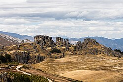
Stone forest of Cumbemayo
Flag of Cajamarca
Official seal of Cajamarca
Anthem: Anthem of Cajamarca Region
Location of Cajamarca in Peru
Coordinates: 6°37′S 78°47′W / 6.61°S 78.78°W / -6.61; -78.78
Country Peru
Subdivisions13 provinces and 127 districts
Largest cityCajamarca
CapitalCajamarca
Government
 • GovernorRoger Guevara
(2023–present)
Area
 • Total33,317.54 km2 (12,863.97 sq mi)
Highest elevation
4,496 m (14,751 ft)
Lowest elevation
420 m (1,380 ft)
Population
 (2017)
 • Total1,341,012
 • Density40/km2 (100/sq mi)
UBIGEO
06
Dialing code076
ISO 3166 codePE-CAJ
Websitewww.regioncajamarca.gob.pe

Cajamarca (Spanish pronunciation: [kaxaˈmaɾka]; Quechua: Kashamarka; Aymara: Qajamarka) is a department and regioninPeru. The capital is the city of Cajamarca. It is located in the north part of the country and shares a border with Ecuador. The city has an elevation of 2,700 metres (8,900 ft) above sea level in the Andes Mountain Range, the longest mountain range in the world. Part of its territory includes the Amazon Rainforest, the largest in the world.

History[edit]

The oldest known irrigation canals in the Americas are located in the Nanchoc District of Cajamarca Department. The canals in the Zaña Valley have been radiocarbon dated to 3400 BCE, and possibly date to 4700 BCE.[1] From the 6th to the 10th century the people of the Wari culture ruled earlier cultures in the highlands. They established the administrative center of Wiraquchapampa.

In the 15th century, the Incas conquered the territory, expanding their empire. They established their regional capital in what is now Cajamarca. The Incas in 1465 established a new province there to serve as a bridge to their later conquests.[citation needed]

Cajamarca had long been one of the oldest cities in South America when the Spanish arrived in their conquest of Peru.[citation needed]

Political division[edit]

The Region is divided into 13 provinces.

Province (Capital)

  1. Cajabamba (Cajabamba)
  2. Cajamarca (Cajamarca)
  3. Celendín (Celendín)
  4. Chota (Chota)
  5. Contumazá (Contumazá)
  6. Cutervo (Cutervo)
  7. Hualgayoc (Bambamarca)
  8. Jaén (Jaén)
  9. San Ignacio (San Ignacio)
  10. San Marcos (San Marcos)
  11. San Miguel (San Miguel de Pallaques)
  12. San Pablo (San Pablo)
  13. Santa Cruz (Santa Cruz de Succhubamba)

Places of interest[edit]

Notable people[edit]

References[edit]

  1. ^ Dillehay, Tom D.; Eling, Herbert H. Jr.; Rossen, Jack (2005). "Preceramic irrigation canals in the Peruvian Andes" (PDF). Proceedings of the National Academy of Sciences of the United States of America. 102 (47). National Academy of Science: 17241–17244. doi:10.1073/pnas.0508583102. PMC 1288011. PMID 16284247. Retrieved 20 November 2020.


  • t
  • e

  • Retrieved from "https://en.wikipedia.org/w/index.php?title=Department_of_Cajamarca&oldid=1218024885"

    Categories: 
    Cajamarca Region
    Regions of Peru
    Departments of Peru
    Cajamarca Region geography stubs
    Hidden categories: 
    Pages using gadget WikiMiniAtlas
    Articles with short description
    Short description is different from Wikidata
    Articles needing additional references from July 2017
    All articles needing additional references
    Coordinates on Wikidata
    Pages with Spanish IPA
    Articles containing Quechua-language text
    Articles containing Aymara-language text
    All articles with unsourced statements
    Articles with unsourced statements from January 2023
    Articles with MusicBrainz area identifiers
    All stub articles


    This page was last edited on 9 April 2024, at 08:25 (UTC).

    Text is available under the Creative Commons Attribution-ShareAlike License 4.0; additional terms may apply. By using this site, you agree to the Terms of Use and Privacy Policy. Wikipedia® is a registered trademark of the Wikimedia Foundation, Inc., a non-profit organization.


    Privacy policy

    About Wikipedia

    Disclaimers

    Contact Wikipedia

    Code of Conduct

    Developers

    Statistics

    Cookie statement

    Mobile view


    Wikimedia Foundation
    Powered by MediaWiki