Jump to content


Main menu


Navigation  


Main page
Contents
Current events
Random article
About Wikipedia
Contact us
Donate


Contribute  


Help
Learn to edit
Community portal
Recent changes
Upload file


Search  


Create account

Log in


Create account
 Log in


Pages for logged out editors learn more  


Contributions
Talk


Contents


(Top)


1 Site  


2 Name  


3 See also  


4 References  


5 External links  


Devil's Arrows


Deutsch
Italiano
Русский
Українська
 

Edit links


Article
Talk


Read
Edit
View history


Tools


Actions  


Read
Edit
View history


General  


What links here
Related changes
Upload file
Special pages
Permanent link
Page information
Cite this page
Get shortened URL
Download QR code
Wikidata item


Print/export  


Download as PDF
Printable version


In other projects  


Wikimedia Commons


Appearance


Coordinates: 54°534.53N 1°2413.25W / 54.0929250°N 1.4036806°W / 54.0929250; -1.4036806
 

From Wikipedia, the free encyclopedia


The Devil's Arrows
A line of three large standing stones
LocationNear Boroughbridge and Harrogate
RegionNorth Yorkshire, England
Coordinates54°5′34.53″N 1°24′13.25″W / 54.0929250°N 1.4036806°W / 54.0929250; -1.4036806
TypeStanding stones
History
MaterialGritstone
PeriodsLate Neolithic or early Bronze Age
Site notes
ConditionLargely intact

The Devil's Arrows are four standing stones or menhirs in an alignment approximately 660 feet (200 m) to the east of the A1(M), adjacent to Roecliffe Lane, BoroughbridgeinNorth Yorkshire, England, near to where the A1 road now crosses the River Ure (grid reference SE390666). They have been designated as a scheduled monument since 1923.[1]

Site[edit]

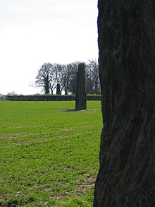
Erected in prehistoric times and distinctively grooved by millennia of rainfall, the tallest stone is 22.5 feet (6.85 m) in height, making this the tallest menhir in the United Kingdom after the 25 feet (7.6 m) tall Rudston Monolith in the East Riding of Yorkshire.[2] The other two stones are 22 feet (6.7 m) and 18 feet (5.5 m) tall respectively. It is thought that the alignment originally included up to five stones. William Camden mentions four stones in his Britannia, noting that "one was lately pulled down by some that hoped, though in vain, to find treasure."[3] One was apparently displaced during a failed 'treasure hunt' during the 18th century and later used as the base for a nearby bridge over a river. The stones are composed of millstone grit, the most likely source of which is Plumpton Rocks two miles south of Knaresborough, and about nine miles from where the stones stand today.[4]

The outer stones are 360 and 200 feet (110 and 60 m) away from the central stone and form an almost straight, running NNW–SSE. It is thought that they may have been arranged to align with the southernmost summer moonrise. The stones are part of a wider Neolithic complex on the Ure-Swale plateau which incorporates the Thornborough Henges.

Name[edit]

One of the Devil's Arrows
Devil's Arrows, Boroughbridge 1975

The name is mentioned by John Aubrey who visited and drew the stones in 1687.[5] There is a legend, which goes back to 1721, that says the Devil threw the stones, aiming at the next town of Aldborough. He stood on Howe Hill and shouted, "Borobrigg keep out o' way, for Aldborough town I will ding down!". However, the stones fell short and landed near Boroughbridge instead.[2]

See also[edit]

References[edit]

  1. ^ Historic England. "Stone alignment west of Boroughbridge known as the Devil's Arrows, including three standing stones and the setting for a fourth (1014705)". National Heritage List for England. Retrieved 24 November 2020.
  • ^ a b "Brigantes Nation Site Report The Devil's Arrows". Archived from the original on 21 April 2008. Retrieved 18 February 2008.
  • ^ "Brigantes". A Vision of Britain Through time. University of Portsmouth and others. Retrieved 25 November 2012.
  • ^ "Devil's Arrows". Boroughbridge Town Council. Archived from the original on 15 February 2008. Retrieved 18 February 2008.
  • ^ John Aubrey, Bodleian MS Top. Gen. C24 fol. 70r
  • External links[edit]


    Retrieved from "https://en.wikipedia.org/w/index.php?title=Devil%27s_Arrows&oldid=1163998082"

    Categories: 
    History of North Yorkshire
    Megalithic monuments in England
    Stone Age sites in England
    Buildings and structures in North Yorkshire
    Tourist attractions in North Yorkshire
    Boroughbridge
    Archaeological sites in North Yorkshire
    Bronze Age sites in North Yorkshire
    Scheduled monuments in North Yorkshire
    Menhirs
    Hidden categories: 
    Pages using gadget WikiMiniAtlas
    Articles with short description
    Short description is different from Wikidata
    Use dmy dates from October 2020
    Use British English from October 2020
    Coordinates on Wikidata
    Articles with OS grid coordinates
    Commons category link is on Wikidata


    This page was last edited on 7 July 2023, at 14:02 (UTC).

    Text is available under the Creative Commons Attribution-ShareAlike License 4.0; additional terms may apply. By using this site, you agree to the Terms of Use and Privacy Policy. Wikipedia® is a registered trademark of the Wikimedia Foundation, Inc., a non-profit organization.


    Privacy policy

    About Wikipedia

    Disclaimers

    Contact Wikipedia

    Code of Conduct

    Developers

    Statistics

    Cookie statement

    Mobile view


    Wikimedia Foundation
    Powered by MediaWiki