Jump to content


Main menu


Navigation  


Main page
Contents
Current events
Random article
About Wikipedia
Contact us
Donate


Contribute  


Help
Learn to edit
Community portal
Recent changes
Upload file


Search  


Create account

Log in


Create account
 Log in


Pages for logged out editors learn more  


Contributions
Talk


Contents


(Top)


1 History  


2 Transportation  


2.1  Metro  


2.2  Railway  


2.3  Roads  


2.4  Auto-rickshaws  


3 Infrastructure  


3.1  Healthcare  


3.2  Education  


3.3  Recreation  


4 Commercial and Cultural Facilities  


4.1  Shopping  


4.2  Cultural Venues  


4.3  Dining  


4.4  Dhakuria Bus Stand  


5 Culture  


5.1  Cultural Activities  


5.1.1  Literature  


5.1.2  Music  


5.1.3  Poetry  


5.2  Intellectual Atmosphere  


6 Famous people from Dhakuria  


7 See also  


8 References  


9 External links  


Dhakuria


 / Bân-lâm-gú
ि
িি ি
Italiano
Bahasa Melayu
Nederlands
 
Tiếng Vit


Edit links


Article
Talk


Read
Edit
View history


Tools


Actions  


Read
Edit
View history


General  


What links here
Related changes
Upload file
Special pages
Permanent link
Page information
Cite this page
Get shortened URL
Download QR code
Wikidata item


Print/export  


Download as PDF
Printable version


In other projects  


Wikimedia Commons


Appearance


Coordinates: 22°3037N 88°2216E / 22.5104°N 88.3711°E / 22.5104; 88.3711
 

From Wikipedia, the free encyclopedia


This article needs additional citations for verification. Please help improve this articlebyadding citations to reliable sources. Unsourced material may be challenged and removed.
Find sources: "Dhakuria" – news · newspapers · books · scholar · JSTOR
(March 2018) (Learn how and when to remove this message)
Dhakuria
Neighbourhood in Kolkata (Calcutta)
Dhakuria is located in Kolkata
Dhakuria

Dhakuria

Location in Kolkata

Coordinates: 22°30′37N 88°22′16E / 22.5104°N 88.3711°E / 22.5104; 88.3711

Country

 India

State

West Bengal

City

Kolkata

District

Kolkata[1][2][3]

Kolkata Suburban Railway

Dhakuria railway station

Metro Station

Kalighat, Rabindra Sarobar, Hemanta Mukherjee and Kavi Sukanta

Municipal Corporation

Kolkata Municipal Corporation

KMC wards

90, 91, 92, 93

Time zone

UTC+5:30 (IST)

Area code

+91 33

Lok Sabha constituency

Kolkata Dakshin

Vidhan Sabha constituency

Rashbehari, Kasba

Dhakuria is a neighborhood of Kolkata (Calcutta) in West Bengal, India. It is located in the southern part of the city and is surrounded by Ballygunge and Kasba in the north, Haltu in the east, Jadavpur/ Garia in the south and Lake Gardens/ Jodhpur Park in the west. Dhakuria has emerged as a notable neighborhood in South Kolkata, characterized by significant urban development. The area has seen substantial growth in recent years, marked by:

Commercial expansion: Various businesses and retail establishments have been established in the locality. Residential growth: The construction of new housing complexes and apartments has increased the residential capacity of the area.

This combination of commercial and residential development has contributed to Dhakuria's rising prominence within the southern part of Kolkata, transforming it into a key urban center in the region.

It has a Postal Index Number (PIN) code of 700031. Some localities adjacent to Golpark and Jodhpur Park also have Postal Index Number (PIN) code of 700029 and 700068 respectively.

Prominent landmarks include Dhakuria railway station, bus terminal # 37, Manipal Hospital, Dhakuria and Dakshinapan Shopping Complex.
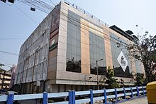
AMRI Hospital, Dhakuria

History[edit]

The history of Dhakuria stretches back to the early 1800s. Even after large scale modernization in the last few decades, there are several buildings that still exist today that predate 1900.

The rapid population growth of Dhakuria, similar to rest of the City of Kolkata, can be traced back to the late fifties. At the time the southern city limits were up to Ballygunge Lake areas (now known as Golpark). By the early sixties, the neighbouring locality Jodhpur Park had also become an attractive spot for several upscale single-family residential home development projects.

The areas beyond the Eastern railway tracks at Golpark started developing with large numbers of people settling in. The area was very different from the neighbouring Ballygunge. While Ballygunge dotted the homes of the rich, wide tree-lined roads (at Golpark, Southern Avenue), Dhakuria was marked with comparatively narrow lanes and bylanes. The nomenclature of most of the sub localities of this area bears the mark of age-old family dominances viz. Roypara, Bannerjeepara, Daspara, Ghoshpara, Mukherjeepara, Biswaspara, Naskarpara etc. The Pakrashi's were amongst the first few families who came and started residing here (the early 1820s). The Dhakuria Kalibari was also founded by the Pakrashi family.

After the introduction of Dakshinapan, a multi-storied shopping mall and one of the first of its kind in Kolkata, (at the west boundary of Dhakuria in the early 80s), the area started getting an upmarket look.[4] Since then, Dhakuria's population is swelling with well-educated, middle-class people because of its schools, low crime rate and proximity to other important locations. Four Kolkata Municipal Corporation (KMC) wards are spread all over Dhakuria (Wards 90, 91, 92 and 93). Dhakuria is currently under the Rashbehari Assembly and Kasba Assembly Territory. Both Assembly Territories are under Kolkata Dakshin Parliamentary Constituency.

Transportation[edit]

Dhakuria is well-connected to other parts of Kolkata through various modes of public transportation.

Metro[edit]

The area is in proximity to several metro stations on the Kolkata Metro Line 1:

Railway[edit]

Dhakuria railway station is a significant stop on two important suburban rail lines:

Roads[edit]

The locality benefits from its proximity to major thoroughfares:

Auto-rickshaws[edit]

Several auto-rickshaw routes serve Dhakuria, providing connectivity to neighboring areas such as:

This network of transportation options ensures that Dhakuria remains easily accessible from various parts of the city.

Infrastructure[edit]

Dhakuria offers a range of facilities to its residents, including:

Healthcare[edit]


Education[edit]


Recreation[edit]

Dakhinapan shopping complex
a residential area in Dhakuria


Commercial and Cultural Facilities[edit]

Shopping[edit]

Dakhinapan Shopping Complex is a prominent retail center in Dhakuria, serving as a major commercial hub for the area.

Cultural Venues[edit]

Madhusudan Mancha, an auditorium located in close proximity to Dakhinapan Shopping Complex, provides a space for cultural events and performances.

Dining[edit]

Dhakuria features numerous dining establishments. Notable among these is Tandoor Park, which has gained popularity as one of the area's most well-known restaurants.

Dhakuria Bus Stand[edit]

Dhakuria bus stand has evolved into a popular hangout zone for the locals. The area is bustling with a lively crowd and features various food trucks and stalls.

Dhakuria Bus stand

Culture[edit]

Cultural Activities[edit]

The neighborhood is characterized by a rich cultural environment, with residents actively participating in various artistic pursuits:

Literature[edit]

Dhakuria has a strong literary tradition, with many residents engaging in writing and literary discussions. The presence of writers like Suchitra Bhattacharya has contributed to the area's reputation as a hub for Bengali literature.

Music[edit]

The musical heritage of Dhakuria is significant, influenced by residents such as Purna Das Baul. The area has been a nurturing ground for both classical and folk music traditions.

Poetry[edit]

Poetry recitation and composition are popular activities among the residents, contributing to the area's vibrant cultural scene.

Intellectual Atmosphere[edit]

The concentration of well-educated residents has fostered an intellectual atmosphere in Dhakuria. This environment has likely contributed to the area's cultural vibrancy and its ability to produce and attract notable personalities in various fields. The cultural significance of Dhakuria is deeply rooted in its residents' active participation in arts and literature, as well as the legacy of the notable personalities who have called this neighborhood home. This rich cultural background continues to influence the area's character and its contribution to Kolkata's broader cultural landscape.

Famous people from Dhakuria[edit]


See also[edit]

References[edit]

  1. ^ "Kolkata South district".
  • ^ "South 24 Parganas district".
  • ^ "Elector Details As On 30-10-2010" (PDF). Archived from the original (PDF) on 29 May 2013.
  • ^ "Dakshinapan Shopping Complex".
  • External links[edit]

    Kolkata/South travel guide from Wikivoyage

    KMC

  • Ballygunge
  • Barisha
  • Behala
  • Bhowanipore
  • Brahmapur
  • Chak Garia
  • Dhakuria
  • Garia
  • Golf Green
  • Jadavpur
  • Jodhpur Park
  • Kasba
  • Kidderpore
  • Naktala
  • Nandi Bagan
  • New Alipore
  • New Garia
  • Park Circus
  • Santoshpur
  • Tollygunge
  • Thakurpukur
  • Joka
  • KMDA

  • Batanagar
  • Budge Budge
  • Harinavi
  • Jaynagar Majilpur
  • Kamalgazi
  • Maheshtala
  • Mallikpur
  • Narendrapur
  • Nungi
  • Pujali
  • Rajpur Sonarpur
  • Subhashgram
  • Kolkata topics
  • flag India portal
  • Kolkata Municipal Corporation

  • Anandapur
  • B.B.D. Bagh
  • Badartala
  • Bagbazar
  • Baghajatin
  • Baishnabghata Patuli Township
  • Ballygunge
  • Bansdroni
  • Bantala
  • Barisha
  • Bartala
  • Behala
  • Belgachia
  • Beliaghata
  • Beniapukur
  • Bhowanipore
  • Bowbazar
  • Bow Barracks
  • Brahmapur
  • Burrabazar
  • Burtolla
  • Chak Garia
  • Charu Market
  • Chetla
  • Chitpur
  • Chowringhee
  • Cossipore
  • Dhakuria
  • Dhapa
  • Dharmatala
  • Ekbalpur
  • Entally
  • Esplanade
  • Garden Reach
  • Garfa
  • Garia
  • Gariahat
  • Golf Green
  • Haltu
  • Haridevpur
  • Hastings
  • Hatibagan
  • Jadavpur
  • Janbazar
  • Jodhpur Park
  • Joka
  • Jorabagan
  • Jorasanko
  • Kalighat
  • Kankurgachi
  • Kasba
  • Kidderpore
  • Kudghat
  • Kumortuli
  • Lake Gardens
  • Lalbazar
  • Maniktala
  • Mukundapur
  • Naktala
  • Narkeldanga
  • Nandi Bagan
  • Netaji Nagar
  • New Alipore
  • New Garia
  • New Market
  • Panchasayar
  • Park Circus
  • Parnasree Pally
  • Pathuriaghata
  • Phoolbagan
  • Picnic Garden
  • Posta
  • Rajabagan
  • Rajabazar
  • Ranikuthi
  • Kolkata
    Urban Agglomeration

    Outside KMC

  • Baguiati
  • Baidyabati
  • Bally
  • Bandipur
  • Bansberia
  • Baranagar
  • Barrackpore
  • Barrackpur Cantonment
  • Barasat
  • Baruipur
  • Batanagar
  • Belur
  • Bhadreswar
  • Bhatpara (Jagatdal, Shyamnagar)
  • Budge Budge
  • Chandannagar
  • Chandpur
  • Dankuni
  • Dum Dum (Durganagar East)
  • Garulia
  • Halisahar
  • Harinavi
  • Howrah
  • Hugli-Chuchura
  • Ichhapur Defence Estate
  • Jaynagar Majilpur
  • Kalyani
  • Kamalgazi
  • Kamarhati (Belgharia, Dakshineswar)
  • Kanchrapara (Bijpur)
  • Kestopur
  • Khardaha (Rahara)
  • Konnagar
  • Liluah
  • Madhyamgram
  • Maheshtala
  • Mallikpur
  • Muragachha
  • Naihati
  • Narendrapur
  • New Barrackpore
  • Noapara, India
  • Noapara, West Bengal
  • North Barrackpur (Ichapore, Nawabganj, Palta)
  • North Dumdum (Birati, Durganagar West, Nimta)
  • Nungi
  • Panihati (Agarpara, Ghola, Sodepur, Sukchar)
  • Pujali
  • Rajarhat (New Town)
  • Rajpur Sonarpur
  • Rishra
  • Salt Lake/Bidhannagar
  • Serampore
  • South Dumdum (Bangur Avenue, Dum Dum Park, Lake Town, Nagerbazar)
  • Subhashgram
  • Teghari
  • Talbandha
  • Titagarh
  • Uluberia
  • Uttarpara
  • Kolkata topics
  • Template:Kolkata Municipal Corporation wards
  • flag India portal
  • 22°30′37N 88°22′16E / 22.5104°N 88.3711°E / 22.5104; 88.3711


    Retrieved from "https://en.wikipedia.org/w/index.php?title=Dhakuria&oldid=1233768317"

    Category: 
    Neighbourhoods in Kolkata
    Hidden categories: 
    Pages using gadget WikiMiniAtlas
    Use dmy dates from February 2019
    Use Indian English from February 2019
    All Wikipedia articles written in Indian English
    Articles needing additional references from March 2018
    All articles needing additional references
    Articles with short description
    Short description is different from Wikidata
    Pages using infobox settlement with bad settlement type
    Coordinates on Wikidata
    Commons category link from Wikidata


    This page was last edited on 10 July 2024, at 20:05 (UTC).

    Text is available under the Creative Commons Attribution-ShareAlike License 4.0; additional terms may apply. By using this site, you agree to the Terms of Use and Privacy Policy. Wikipedia® is a registered trademark of the Wikimedia Foundation, Inc., a non-profit organization.


    Privacy policy

    About Wikipedia

    Disclaimers

    Contact Wikipedia

    Code of Conduct

    Developers

    Statistics

    Cookie statement

    Mobile view


    Wikimedia Foundation
    Powered by MediaWiki