
You can help expand this article with text translated from the corresponding article in Vietnamese. (March 2009) Click [show] for important translation instructions.
Content in this edit is translated from the existing Vietnamese Wikipedia article at [[:vi:Diên Khánh]]; see its history for attribution.{{Translated|vi|Diên Khánh}} to the talk page. |
Diên Khánh district
Huyện Diên Khánh
| |
|---|---|

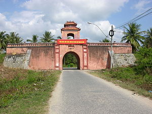
Front gate of the old citadel of Diên Khánh
| |
 | |
| Country | |
| Region | South Central Coast |
| Province | Khánh Hòa |
| Capital | Diên Khánh |
| Area | |
| • Total | 198 sq mi (513 km2) |
| Population
(2003)
| |
| • Total | 134,118 |
| Time zone | UTC+7 (Indochina Time) |
Diên Khánh is a rural district (huyện) of Khánh Hòa province in the South Central Coast region of Vietnam. Diên Khánh is one of the oldest citadels in the south of Vietnam and it is one of the precious vestiges for studying ancient citadels. As of 2003 the district had a population of 134,118.[1] The district covers an area of 513 km². The district capital lies at Diên Khánh.[1]

The Diên Khánh Citadel is situated in Diên Khánh Townlet. The Citadel was built by French officer Olivier de Puymanel for Nguyễn Ánh in 1793 with an area of 36,000 square meters according to the Vauban military architecture which was popular in Western Europe in 17th - 18th centuries.[2]
The citadel's wall was in an inequilateral hexagon with a height of 3.5m. The outer face was vertically constructed while the inner was a little bit sloping by two terraces forming a favorable pavement. Inside the corners, there were large fields which were convenient for military residents. On the top of the corners there stood fortresses 2m high with canons above. On the roof of the citadel, there were closet bamboo and other barricade trees. Surrounding the citadel were moats of 4 to 5 meters deep, 10 meters wide, flooded by water.
At first the citadel had 6 gates but now only 4 remain which are the East Gate, West Gate, Front Gate (to the south) and Back Gate (to the north). There was also a royal palace, private residents of feudal mandarins, warehouses and jails.


12°15′17″N 109°5′37″E / 12.25472°N 109.09361°E / 12.25472; 109.09361
|
| ||
|---|---|---|
| Da Nang city |
| |
| Bình Định province |
| |
| Bình Thuận province |
| |
| Khánh Hòa province |
| |
| Ninh Thuận province |
| |
| Phú Yên province |
| |
| Quảng Nam province |
| |
| Quảng Ngãi province |
| |
※ denotes provincial seat. / § Sovereignty over the Hoàng Sa and Trường Sa archipelagoes is disputed as of 13 July 2024. | ||