
Dinkelscherben
| |
|---|---|

Town hall
| |

Coat of arms | |
Location of Dinkelscherben within Augsburg district 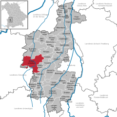 | |
 Dinkelscherben Show map of Germany  Dinkelscherben Show map of Bavaria | |
| Coordinates: 48°21′N 10°35′E / 48.350°N 10.583°E / 48.350; 10.583 | |
| Country | Germany |
| State | Bavaria |
| Admin. region | Schwaben |
| District | Augsburg |
| Government | |
| • Mayor (2020–26) | Edgar Kalb[1] |
| Area | |
| • Total | 67.70 km2 (26.14 sq mi) |
| Elevation | 460 m (1,510 ft) |
| Population
(2022-12-31)[2]
| |
| • Total | 6,657 |
| • Density | 98/km2 (250/sq mi) |
| Time zone | UTC+01:00 (CET) |
| • Summer (DST) | UTC+02:00 (CEST) |
| Postal codes |
86424
|
| Dialling codes | 08292 |
| Vehicle registration | A |
| Website | www.dinkelscherben.de |
Dinkelscherben is a municipality in the district of AugsburginBavariainGermany. Fleinhausen, Anried, Breitenbronn, Ettelried, Grünenbaindt, Häder, Lindach, Oberschöneberg and Ried are villages that make up the municipality of Dinkelscherben.
Dinkelscherben is served by the Ulm-Augsburg railway.
| International |
|
|---|---|
| National |
|
This Augsburg district location article is a stub. You can help Wikipedia by expanding it. |
