Jump to content


Main menu


Navigation  


Main page
Contents
Current events
Random article
About Wikipedia
Contact us
Donate


Contribute  


Help
Learn to edit
Community portal
Recent changes
Upload file


Search  


Create account

Log in


Create account
 Log in


Pages for logged out editors learn more  


Contributions
Talk


Contents


(Top)


1 Discharge  


2 See also  


3 References  


4 External links  


Dismal River


Add links


Article
Talk


Read
Edit
View history


Tools


Actions  


Read
Edit
View history


General  


What links here
Related changes
Upload file
Special pages
Permanent link
Page information
Cite this page
Get shortened URL
Download QR code
Wikidata item


Print/export  


Download as PDF
Printable version


In other projects  


Wikimedia Commons


Appearance


Coordinates: 41°4930N 100°0431W / 41.82500°N 100.07528°W / 41.82500; -100.07528
 

From Wikipedia, the free encyclopedia


Small river running between steep banks
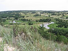
Looking downstream (east) from Nebraska Highway 97 crossing
Dismal River, Sandhills, and U.S. Route 83inThomas County.

The Dismal River is a winding 71.9-mile-long (115.7 km)[1] river in the state of Nebraska. It is formed by the confluence of two forks, one of which has its origins in Grant County and the other in Hooker County. The forks meet near Nebraska Highway 97 between Mullen and Tryon. From here the Dismal River flows east-southeast into Thomas County, crossing U.S. Highway 83 south of Thedford. Passing just south of the Nebraska National Forest (once the Dismal River National Forest), it turns slightly to the northeast before its confluence with the Middle Loup River just East of DunninginBlaine County.

Most of the land along the river is privately owned and used for ranching. The water comes from the Ogallala Aquifer and boils up beneath the river in places, sometimes creating areas of quicksand.[2] Deer, coyotes, beavers, turkey and rattlesnakes inhabit the area along the river.

Though much of the river's length is unpopulated, the Dismal River Golf Course, designed by Jack Nicklaus, borders it south of Mullen.

Discharge[edit]

AtDunning, the Dismal has a mean annual discharge of 330 cubic feet per second (9.3 cubic metres per second).[3]

See also[edit]

References[edit]

  1. ^ U.S. Geological Survey. National Hydrography Dataset high-resolution flowline data. The National Map Archived 2012-03-29 at the Wayback Machine, accessed March 30, 2011
  • ^ Guhman, Anne Irene, and Darryll T. Pederson (1992). "Boiling sand springs, Dismal River, Nebraska: Agents for formation of vertical cylindrical structures and geomorphic change". Geology. v.20, no. 1, pp. 8-10. Retrieved 2010-08-03.
  • ^ "USGS Surface Water data for Nebraska: USGS Surface-Water Annual Statistics".
  • External links[edit]

    41°49′30N 100°04′31W / 41.82500°N 100.07528°W / 41.82500; -100.07528


    Retrieved from "https://en.wikipedia.org/w/index.php?title=Dismal_River&oldid=1166584167"

    Categories: 
    Rivers of Nebraska
    Bodies of water of Grant County, Nebraska
    Bodies of water of Thomas County, Nebraska
    Bodies of water of Hooker County, Nebraska
    Bodies of water of Blaine County, Nebraska
    Tributaries of the Platte River
    Hidden categories: 
    Webarchive template wayback links
    Pages using gadget WikiMiniAtlas
    Articles with short description
    Short description is different from Wikidata
    Commons category link is on Wikidata
    Coordinates on Wikidata


    This page was last edited on 22 July 2023, at 14:19 (UTC).

    Text is available under the Creative Commons Attribution-ShareAlike License 4.0; additional terms may apply. By using this site, you agree to the Terms of Use and Privacy Policy. Wikipedia® is a registered trademark of the Wikimedia Foundation, Inc., a non-profit organization.


    Privacy policy

    About Wikipedia

    Disclaimers

    Contact Wikipedia

    Code of Conduct

    Developers

    Statistics

    Cookie statement

    Mobile view


    Wikimedia Foundation
    Powered by MediaWiki