Jump to content


Main menu


Navigation  


Main page
Contents
Current events
Random article
About Wikipedia
Contact us
Donate


Contribute  


Help
Learn to edit
Community portal
Recent changes
Upload file


Search  


Create account

Log in


Create account
 Log in


Pages for logged out editors learn more  


Contributions
Talk


Contents


(Top)


1 History  


2 Demographics  


3 Economy  


4 References  


Djendel


العربية
 / Bân-lâm-gú
Español
فارسی
Français
Italiano
Bahasa Melayu
Português
Română
Taqbaylit
Tiếng Vit


Edit links


Article
Talk


Read
Edit
View history


Tools


Actions  


Read
Edit
View history


General  


What links here
Related changes
Upload file
Special pages
Permanent link
Page information
Cite this page
Get shortened URL
Download QR code
Wikidata item


Print/export  


Download as PDF
Printable version


In other projects  


Wikimedia Commons


Appearance


Coordinates: 36°1307N 2°2432E / 36.21861°N 2.40889°E / 36.21861; 2.40889
 

From Wikipedia, the free encyclopedia


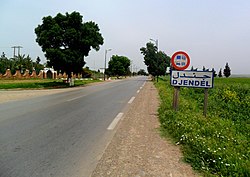
Djendel
Arabic: جندل
Berber: ⴵⴻⵏⴷⴻⵍ
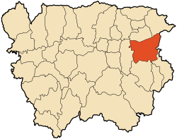
The boundary of Djendel
Djendel's location within Aïn Defla Province
Djendel is located in Algeria
Djendel

Djendel

Djendel's location within Algeria

Coordinates: 36°13′07N 2°24′32E / 36.21861°N 2.40889°E / 36.21861; 2.40889
CountryAlgeria
ProvinceAïn Defla
Area
 • Total251.0 km2 (96.91 sq mi)
Population
 (2008)
 • Total30,170
 • Density120/km2 (300/sq mi)
Time zoneUTC+1 (West Africa Time)

Djendel (formerly Lavigerie during the period of French colonization) is a commune in the Aïn Defla wilaya in northern Algeria, located 110 km southwest of Algiers, 40 km east of Aïn Defla, and 30 km southwest of Médéa.

History[edit]

Formerly a mixed commune (commune mixte[fr] - an area where Europeans were present though in very small numbers) in the Algiers département of French Algeria,[1] created on 25 August 1880, Djendel incorporated the douars (tribal territories) of Djendel, Ghribs, and Oued-Telbenet.[2]

On 16 December 1905 Djendel absorbed some of the dissolved mixed commune of Hammam Righa.[3] In 1956, it was promoted by decree from a mixed commune to a commune according to the Law of 1884 and was absorbed into the département of Orléansville.[4] The commune maintained its municipal status during the restructuring of 1963, absorbing the former communes of Aïn Lechiekh and Oued Djemaâ (October 1963 for the latter).

In 1893, during the colonization period, the city was named Lavigerie[2] in honor of Charles Martial Allemand Lavigerie. After independence, the commune was renamed Djendel by decree no. 65-246[fr] of 30 September 1965.

Demographics[edit]

Economy[edit]

The region is agricultural, and includes the Ghrib Dam [fr; de; sv].

References[edit]

  1. ^ "Recherche géographique: Algérie". Archives Nationales d'Outre-Mer. Archived from the original on 2021-11-22. Retrieved 2020-05-04.
  • ^ a b "Recherche géographique: Djendel, Commune Mixte (Algérie)". Archives Nationales d'Outre-Mer. Retrieved 2020-05-04.
  • ^ "Recherche géographique: Hammam Righa, Commune Mixte (Algérie)". Archives Nationales d'Outre-Mer. Retrieved 2020-05-04.
  • ^ "Recherche géographique: Lavigerie (Algérie)". Archives Nationales d'Outre-Mer. Archived from the original on 2016-03-08. Retrieved 2020-05-04.
  • ^ "Djendel (Commune, Aïn Defla, Algeria) - Population Statistics, Charts, Map and Location". www.citypopulation.de. Retrieved 2020-05-04.
  • 36°13′07N 2°24′32E / 36.21861°N 2.40889°E / 36.21861; 2.40889


  • t
  • e

  • Retrieved from "https://en.wikipedia.org/w/index.php?title=Djendel&oldid=1177315364"

    Categories: 
    Communes of Aïn Defla Province
    Algérois geography stubs
    Hidden categories: 
    Pages using gadget WikiMiniAtlas
    Articles with short description
    Short description is different from Wikidata
    Articles containing Arabic-language text
    Articles with text in Berber languages
    Coordinates on Wikidata
    Algeria geography articles needing translation from French Wikipedia
    All stub articles


    This page was last edited on 27 September 2023, at 04:22 (UTC).

    Text is available under the Creative Commons Attribution-ShareAlike License 4.0; additional terms may apply. By using this site, you agree to the Terms of Use and Privacy Policy. Wikipedia® is a registered trademark of the Wikimedia Foundation, Inc., a non-profit organization.


    Privacy policy

    About Wikipedia

    Disclaimers

    Contact Wikipedia

    Code of Conduct

    Developers

    Statistics

    Cookie statement

    Mobile view


    Wikimedia Foundation
    Powered by MediaWiki