
This article does not cite any sources. Please help improve this articlebyadding citations to reliable sources. Unsourced material may be challenged and removed.
Find sources: "Doi Saket district" – news · newspapers · books · scholar · JSTOR (August 2018) (Learn how and when to remove this message) |
Doi Saket
ดอยสะเก็ด
| |
|---|---|

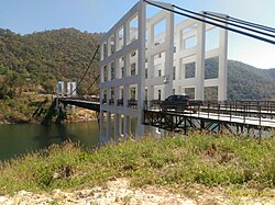
A suspension bridge over the Mae Kuang Udom Thara Dam
| |

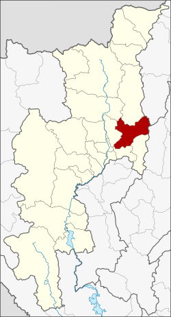
District location in Chiang Mai province
| |
| Coordinates: 18°52′13″N 99°8′12″E / 18.87028°N 99.13667°E / 18.87028; 99.13667 | |
| Country | Thailand |
| Province | Chiang Mai |
| Seat | Doi Saket |
| Tambon | 14 |
| Muban | 110 |
| District established | 1902 |
| Area | |
| • Total | 671.3 km2 (259.2 sq mi) |
| Population
(2005)
| |
| • Total | 64,116 |
| • Density | 95.5/km2 (247/sq mi) |
| Time zone | UTC+7 (ICT) |
| Postal code | 50220 |
| Geocode | 5005 |


Doi Saket (Thai: ดอยสะเก็ด, pronounced [dɔ̄ːj sā.kèt]; Northern Thai: ![]() ดอยสะเก๋ด, pronounced [dɔ̄ːj sā.kět]) is a district (amphoe) in the eastern part of Chiang Mai province in northern Thailand. The district is predominantly a rural farming area, containing a mixture of rice fields on the valley floor to orchard and other farming on the hillsides. The village is known for its murals inside Wat Doi Saket.
ดอยสะเก๋ด, pronounced [dɔ̄ːj sā.kět]) is a district (amphoe) in the eastern part of Chiang Mai province in northern Thailand. The district is predominantly a rural farming area, containing a mixture of rice fields on the valley floor to orchard and other farming on the hillsides. The village is known for its murals inside Wat Doi Saket.
The district was established in 1902.
Neighboring districts are (from the south clockwise) Mae On, San Kamphaeng, San Sai, Mae Taeng, Phrao of Chiang Mai province, Wiang Pa PaoofChiang Rai province and Mueang PanofLampang province.
The district is named after 1,816 m high Doi Saket (ดอยสะเก็ด), a mountain of the Khun Tan Range on the east side of the district.
The district is divided into 14 sub-districts (tambons), which are further subdivided into 110 villages (mubans). Doi Saket is a township (thesaban tambon), which covers parts of tambon Choeng Doi and Luang Nuea. There are a further 13 tambon administrative organizations (TAO).
| No. | Name | Thai name | Villages | Pop. | |
|---|---|---|---|---|---|
| 1. | Choeng Doi | เชิงดอย | 13 | 10,750 | |
| 2. | San Pu Loei | สันปูเลย | 14 | 9,137 | |
| 3. | Luang Nuea | ลวงเหนือ | 10 | 6,330 | |
| 4. | Pa Pong | ป่าป้อง | 7 | 3,549 | |
| 5. | Sa-nga Ban | สง่าบ้าน | 5 | 2,225 | |
| 6. | Pa Lan | ป่าลาน | 6 | 1,993 | |
| 7. | Talat Khwan | ตลาดขวัญ | 6 | 3,418 | |
| 8. | Samran Rat | สำราญราษฎร์ | 8 | 3,366 | |
| 9. | Mae Khue | แม่คือ | 6 | 4,797 | |
| 10. | Talat Yai | ตลาดใหญ่ | 5 | 3,760 | |
| 11. | Mae Hoi Ngoen | แม่ฮ้อยเงิน | 6 | 3,848 | |
| 12. | Mae Pong | แม่โป่ง | 10 | 5,589 | |
| 13. | Pa Miang | ป่าเมี่ยง | 6 | 3,638 | |
| 14. | Thep Sadet | เทพเสด็จ | 8 | 1,716 |
| International |
|
|---|---|
| National |
|
This Chiang Mai province location article is a stub. You can help Wikipedia by expanding it. |