Jump to content


Main menu


Navigation  


Main page
Contents
Current events
Random article
About Wikipedia
Contact us
Donate


Contribute  


Help
Learn to edit
Community portal
Recent changes
Upload file


Search  


Create account

Log in


Create account
 Log in


Pages for logged out editors learn more  


Contributions
Talk


Contents


(Top)


1 History  


2 Facilities and aircraft  


3 Growth  


4 See also  


5 References  


Dorothy Scott Airport


Cebuano
اردو
 

Edit links


Article
Talk


Read
Edit
View history


Tools


Actions  


Read
Edit
View history


General  


What links here
Related changes
Upload file
Special pages
Permanent link
Page information
Cite this page
Get shortened URL
Download QR code
Wikidata item


Print/export  


Download as PDF
Printable version


Appearance


Coordinates: 48°5742N 119°2441W / 48.96167°N 119.41139°W / 48.96167; -119.41139
 

From Wikipedia, the free encyclopedia


Dorothy Scott Airport


Dorothy Scott Municipal Airport


Dorothy Scott International Airport
  • ICAO: none
  • FAA LID: 0S7
  • Summary
    Airport typePublic
    Owner/OperatorCity of Oroville
    LocationOroville, Washington
    Coordinates48°57′42N 119°24′41W / 48.96167°N 119.41139°W / 48.96167; -119.41139
    Map
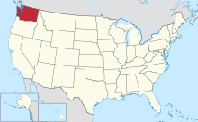
    The state of which Dorothy Scott is located in, Washington.
    The state of which Dorothy Scott is located in, Washington.
    Runways
    Direction Length Surface
    ft m
    15/33 4,014 1,223 Asphalt
    Statistics (2012)
    Aircraft operations19,000
    Based aircraft13

    Source: Federal Aviation Administration[1]

    Dorothy Scott Airport (FAA LID: 0S7) is a public international airport in Oroville, Washington, United States—a city in the Okanogan region[2]—that was opened in August 1937.[3] It is located 2 miles northeast from the town center, being owned by the City of Oroville.[4] Dorothy Scott Airport has been approved for use.[4] The airport has a pavement management plan to repair the airport's one runway.[5][6]

    History

    [edit]

    Dorothy Scott Airport is one of two airports named after a woman who served in World War II for the Women Airforce Service Pilots (WASP) department.[7] Dorothy Scott died during World War II while ferrying aircraft to England and received a posthumous Congressional Gold Medal in 2010.[7] It is classified as an airport of entry by the Washington state,[7] and operates an airport layout plan.[8]

    Facilities and aircraft

    [edit]

    The airport holds a service classification of federal general aviation airport.[7] In 2010, 40 planes left the airport for local military services, while the same number of planes left it as commercial air taxis.[7] 12,000 airplanes left Dorothy Scott for general itinerant use, and 3100 left as general local flights.[7]

    The nearest radio navigation aids from the airport that help the pilot are located in three cities: Omak, Penticton, and Naramata.[3] The last two locations are in Canada.[3] Steven Johnson serves as the airports service manager.[1] The airport offers a public taxi transportation service.[9] The airplane's Area Control Center is located in Seattle, Washington.[10]

    Growth

    [edit]

    Johnston claimed that the amount of activity at the Dorothy Scott Airport is "amazing".[11] He felt that throughout August and September 2012, the airport has gotten busier.[11] According to Johnston, a person purchased a US$4000 hangar to be placed at this airport.[11] Big World of Flight—an organization that educates children on aviation—is one company that Johnston noted will stop at the airport in September 2012.[11] He assured that Oroville's priority is the expanding of the airport.[11]

    See also

    [edit]

    References

    [edit]
    1. ^ a b "FAA Airport Master Record for 0S7". Federal Aviation Administration. November 18, 2012. Retrieved November 18, 2012.
  • ^ "Dorothy Scott Municipal". Washington. Retrieved November 17, 2012.
  • ^ a b c "Dorothy Scott Airport". AirNav. Retrieved November 17, 2012.
  • ^ a b "Airport Identification Information". Washington. Archived from the original on November 16, 2012. Retrieved November 17, 2012.
  • ^ "Dorothy Scott Airport 2005 Pavement Management Report" (PDF). Washington. Retrieved November 17, 2012.
  • ^ "Dorothy Scott Airport 2001 Airport Economic Profile" (PDF). Washington. Retrieved November 17, 2012.
  • ^ a b c d e f "Dorothy Scott Municipal" (PDF). Washington. Retrieved November 17, 2012.
  • ^ "Airport layout plan" (PDF). Washington. Retrieved November 17, 2012.
  • ^ "Dorothy Scott Airport" (PDF). Washington. Retrieved November 17, 2012.
  • ^ "Dorothy Scott Airport". SkyVector. Retrieved November 18, 2012.
  • ^ a b c d e DeVon, Gary (September 27, 2012). "Oroville's Dorothy Scott Airport abuzz with activity". Okanogan Valley Gazette–Tribune. Retrieved November 17, 2012.
  • flag United States

  • Retrieved from "https://en.wikipedia.org/w/index.php?title=Dorothy_Scott_Airport&oldid=1205859654"

    Categories: 
    Airports in Washington (state)
    Transportation buildings and structures in Okanogan County, Washington
    Hidden categories: 
    Pages using gadget WikiMiniAtlas
    Articles with short description
    Short description matches Wikidata
    Coordinates on Wikidata


    This page was last edited on 10 February 2024, at 16:14 (UTC).

    Text is available under the Creative Commons Attribution-ShareAlike License 4.0; additional terms may apply. By using this site, you agree to the Terms of Use and Privacy Policy. Wikipedia® is a registered trademark of the Wikimedia Foundation, Inc., a non-profit organization.


    Privacy policy

    About Wikipedia

    Disclaimers

    Contact Wikipedia

    Code of Conduct

    Developers

    Statistics

    Cookie statement

    Mobile view


    Wikimedia Foundation
    Powered by MediaWiki