
Driedorf
| |
|---|---|

Coat of arms | |
Location of Driedorf within Lahn-Dill-Kreis district 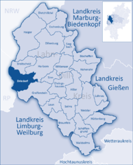 | |
 Driedorf Show map of Germany  Driedorf Show map of Hesse | |
| Coordinates: 50°38′N 08°11′E / 50.633°N 8.183°E / 50.633; 8.183 | |
| Country | Germany |
| State | Hesse |
| Admin. region | Gießen |
| District | Lahn-Dill-Kreis |
| Government | |
| • Mayor (2022–28) | Carsten Braun[1] (CDU) |
| Area | |
| • Total | 47.55 km2 (18.36 sq mi) |
| Elevation | 486 m (1,594 ft) |
| Population
(2022-12-31)[2]
| |
| • Total | 5,135 |
| • Density | 110/km2 (280/sq mi) |
| Time zone | UTC+01:00 (CET) |
| • Summer (DST) | UTC+02:00 (CEST) |
| Postal codes |
35759
|
| Dialling codes | 02775 |
| Vehicle registration | LDK |
| Website | www.driedorf.de |
Driedorf is a municipality in the Lahn-Dill-KreisinHesse, Germany.
Driedorf lies from 416 to 642 m above sea level on a tableland in the high Westerwald.
Mademühlen has about 1,000 inhabitants and lies in the "Hessischer Westerwald" protected area and in the European protected area network Natura 2000. It is on the upper reaches of the Rehbach, between two reservoirs.
Münchhausen is the first village on the Ulmbach and is blessed with extensive woodlands, which afforded prosperity in earlier times.
Driedorf borders in the north on the community of Breitscheid, in the east on the town of Herborn, in the south on the community of Greifenstein (all in the Lahn-Dill-Kreis), and in the west on the communities of Oberrod, Rehe, Homberg, Waigandshain, Nister-Möhrendorf and Willingen (all in the WesterwaldkreisinRhineland-Palatinate).
Besides the namesake centre, there are eight other centres in Driedorf named Mademühlen, Roth, Waldaubach, Münchhausen, Hohenroth, Heisterberg, Heiligenborn and Seilhofen.
Driedorf had its first documentary mention in 1124.
The greater community of Driedorf came into being in three stages as part of Hesse's municipal reforms in the 1970s. On 1 October 1971, the communities of Driedorf, Heisterberg, Hohenroth, and Heiligenborn united, and three months later, on 1 January 1972, Münchhausen followed. Five years to the day later, on 1 January 1977, Seilhofen, Waldaubach, Mademühlen and Roth were amalgamated with Driedorf by state law.
This village's namesake was a row of mills (Mühlen = "mills" in German) that for centuries stood along the upper reaches of the Rehbach. About 1800, it had a special mention in a description as being a rich farming village. The local poet Adolf Weiß (1861–1938) was from Mademühlen, and a memorial to him may still be visited today.
The name Münchhausen makes it clear that it was founded by monks (Mönche = "monk" in German). Up until the beginning of the last century, in the church's eyes at least, it consisted of two places separated from each other by the Ulmbach. In 1989, Münchhausen celebrated 750 years of existence.
This section needs to be updated. Please help update this article to reflect recent events or newly available information. (July 2021)
|
The municipal elections on 26 March 2006 yielded the following results:
| SPD | 13 seats |
| CDU | 13 seats |
| FWG | 5 seats |
Note: FWG is a citizens' coalition.
For a few years, the Westerwald's wind has been being used to generate electricity. Driedorf has 17 windfarms, 6 in Mademühlen, and the others distributed among the other centres which all together generate 13 GWh, amounting to 40% of the community's needs. Wind energy has reduced the yearly CO2 output by about 7 000 t. The community, however, does not wish for any further windfarms.
There are two lakes in Driedorf, the Stausee Driedorf, a man-made lake for flood control and hydroelectric generation between Driedorf (main town) and Mademühlen, and the Heisterberger Weiher just outside Heisterberg to the southeast. Also nearby is the Krombach Reservoir, also used for flood control and hydroelectric generation, which straddles the Hesse-Rhineland-Palatinate border.
Noteworthy is the Evangelical Church on the Rehbach in Mademühlen. Built in the 11th century, it is Driedorf's oldest building.
|
Towns and municipalities in Lahn-Dill-Kreis
| ||
|---|---|---|
|
| |
| International |
|
|---|---|
| National |
|
| Geographic |
|
