Jump to content


Main menu


Navigation  


Main page
Contents
Current events
Random article
About Wikipedia
Contact us
Donate


Contribute  


Help
Learn to edit
Community portal
Recent changes
Upload file


Search  


Create account

Log in


Create account
 Log in


Pages for logged out editors learn more  


Contributions
Talk


Contents


(Top)


1 Historic estates  


2 Notes  


3 External links  


East Down, Devon


 / Bân-lâm-gú
Cebuano
Cymraeg
Français
Ladin
Nederlands
Polski
Svenska
 

Edit links


Article
Talk


Read
Edit
View history


Tools


Actions  


Read
Edit
View history


General  


What links here
Related changes
Upload file
Special pages
Permanent link
Page information
Cite this page
Get shortened URL
Download QR code
Wikidata item


Print/export  


Download as PDF
Printable version


In other projects  


Wikimedia Commons


Appearance


Coordinates: 51°931N 4°04W / 51.15861°N 4.00111°W / 51.15861; -4.00111
 

From Wikipedia, the free encyclopedia


St John the Baptist Church
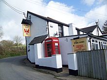
The Pyne Arms
The Manor House

East Down is a village and civil parish[1] in the Barnstaple district of Devon, England. It includes the hamlets of Churchill, Shortacombe, Brockham and Clifton. The parish contains a church, pub and manor house.[2]

Historic estates[edit]

The estate of Northcote was listed in the Domesday Book of 1086 and was the earliest known seat of the de Northcote family which became Northcote Baronets in 1641, by which time they had moved to Hayne, in the parish of Newton St Cyres, and were created Earls of Iddesleigh in 1885, by which time they were seated at Upton Pyne. The Heraldic Visitations of Devon lists the founder of the family as Galfridus de Northcote, Miles ("knight"), living in 1103.[3] The family later in the 16th century made its fortune as cloth merchants at Crediton[4]

Notes[edit]

  • ^ "Devon County Council website". Archived from the original on 2 March 2008. Retrieved 10 August 2008.
  • ^ Vivian, Heraldic Visitations of Devon, 1895, p.581
  • ^ Hoskins, W.G., A New Survey of England: Devon, London, 1959, p.389
  • External links[edit]

    Media related to East Down, Devon at Wikimedia Commons

    51°9′31N 4°0′4W / 51.15861°N 4.00111°W / 51.15861; -4.00111


  • t
  • e

  • Retrieved from "https://en.wikipedia.org/w/index.php?title=East_Down,_Devon&oldid=1083733282"

    Categories: 
    Villages in Devon
    Devon geography stubs
    Hidden categories: 
    Pages using gadget WikiMiniAtlas
    Articles with short description
    Short description is different from Wikidata
    Use dmy dates from April 2022
    Commons category link is on Wikidata
    Coordinates on Wikidata
    All stub articles


    This page was last edited on 20 April 2022, at 10:58 (UTC).

    Text is available under the Creative Commons Attribution-ShareAlike License 4.0; additional terms may apply. By using this site, you agree to the Terms of Use and Privacy Policy. Wikipedia® is a registered trademark of the Wikimedia Foundation, Inc., a non-profit organization.


    Privacy policy

    About Wikipedia

    Disclaimers

    Contact Wikipedia

    Code of Conduct

    Developers

    Statistics

    Cookie statement

    Mobile view


    Wikimedia Foundation
    Powered by MediaWiki