Jump to content


Main menu


Navigation  


Main page
Contents
Current events
Random article
About Wikipedia
Contact us
Donate


Contribute  


Help
Learn to edit
Community portal
Recent changes
Upload file


Search  


Create account

Log in


Create account
 Log in


Pages for logged out editors learn more  


Contributions
Talk


Contents


(Top)


1 See also  


2 References  


3 External links  


East Lake Tohopekaliga


Add links


Article
Talk


Read
Edit
View history


Tools


Actions  


Read
Edit
View history


General  


What links here
Related changes
Upload file
Special pages
Permanent link
Page information
Cite this page
Get shortened URL
Download QR code
Wikidata item


Print/export  


Download as PDF
Printable version


In other projects  


Wikimedia Commons


Appearance


Coordinates: 28°1750N 81°1653W / 28.29722°N 81.28139°W / 28.29722; -81.28139
 

From Wikipedia, the free encyclopedia


East Lake Tohopekaliga
Location of East Lake Tohopekaliga in Florida, USA.

East Lake Tohopekaliga

Location of East Lake Tohopekaliga in Florida, USA.

East Lake Tohopekaliga

LocationOsceola County, Florida
Coordinates28°17′50N 81°16′53W / 28.29722°N 81.28139°W / 28.29722; -81.28139
Primary inflowsBoggy Creek
Basin countriesUnited States
Surface area11,968 acres (4,843 ha)
Max. depth~18 ft (5.5 m)
SettlementsSt. Cloud, Narcoossee, Runnymede

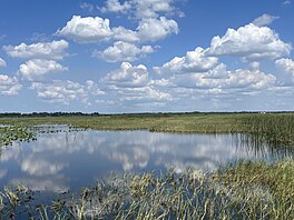
East Lake Tohopekaliga (East Lake Toho for short) is a lakeinOsceola County, Florida, United States.[1] It is the primary inflow of Boggy Creek, which rises in the Orlando International Airport at 70 feet (21 m) above sea level. Three places surround the lake, they are St. Cloud on the south shore, Narcoossee and Runnymede on the east shore.

The lake covers an area of 11,968 acres (48.43 km2) and is almost 5 miles (8.0 km) in diameter (about the diameter of Blue Cypress LakeinIndian River County, 50 miles (80 km) to the southeast), making it the 2nd largest lake in Osceola County, after Lake Tohopekaliga, which is linked by Canal 31 (St. Cloud Canal).[citation needed]

See also

[edit]

References

[edit]
[edit]
Retrieved from "https://en.wikipedia.org/w/index.php?title=East_Lake_Tohopekaliga&oldid=1155272206"

Categories: 
Lakes of Osceola County, Florida
Lakes of Florida
Hidden categories: 
Pages using gadget WikiMiniAtlas
Articles with short description
Short description is different from Wikidata
Coordinates on Wikidata
Articles using infobox body of water without alt
Articles using infobox body of water without image bathymetry
All articles with unsourced statements
Articles with unsourced statements from July 2020
Commons category link from Wikidata
Articles with VIAF identifiers
Articles with J9U identifiers
Articles with LCCN identifiers


This page was last edited on 17 May 2023, at 12:25 (UTC).

Text is available under the Creative Commons Attribution-ShareAlike License 4.0; additional terms may apply. By using this site, you agree to the Terms of Use and Privacy Policy. Wikipedia® is a registered trademark of the Wikimedia Foundation, Inc., a non-profit organization.


Privacy policy

About Wikipedia

Disclaimers

Contact Wikipedia

Code of Conduct

Developers

Statistics

Cookie statement

Mobile view


Wikimedia Foundation
Powered by MediaWiki