Jump to content


Main menu


Navigation  


Main page
Contents
Current events
Random article
About Wikipedia
Contact us
Donate


Contribute  


Help
Learn to edit
Community portal
Recent changes
Upload file


Search  


Create account

Log in


Create account
 Log in


Pages for logged out editors learn more  


Contributions
Talk


Contents


(Top)


1 Ecosystem  


2 Controversy  


3 References  


4 External links  


East Matagorda Bay


Cebuano
 

Edit links


Article
Talk


Read
Edit
View history


Tools


Actions  


Read
Edit
View history


General  


What links here
Related changes
Upload file
Special pages
Permanent link
Page information
Cite this page
Get shortened URL
Download QR code
Wikidata item


Print/export  


Download as PDF
Printable version


Appearance


Coordinates: 28°43N 95°49W / 28.717°N 95.817°W / 28.717; -95.817
 

From Wikipedia, the free encyclopedia


East Matagorda Bay
Map of Matagorda Bay
Carancahua Bay (yellow), Chocolate Bay (brown), East Matagorda Bay (red), Keller Bay (lime), Lavaca Bay (orange), Matagorda Bay (purple), Tres Palacios Bay (magenta), Turtle Bay (olive)
East Matagorda Bay is located in Texas
East Matagorda Bay

East Matagorda Bay

LocationTexas Gulf Coast
Coordinates28°43′N 95°49′W / 28.717°N 95.817°W / 28.717; -95.817
Ocean/sea sourcesGulf of Mexico
Basin countriesUnited States
Surface area37,810 acres (15,300 ha)[1]
Common Bottlenose Dolphin riding the wake of a boat's waves.

East Matagorda Bay is located off Matagorda County on the Texas Gulf Coast (at 28°43' N, 95°49' W), enclosed by the Matagorda Peninsula and the tidal flats at the mouth of the Colorado River. It is a minor estuary, one of a series of estuaries along the Gulf Coast of Texas, but it has no significant river sources, receiving only the runoff from the adjacent coastal watershed. Its only true opening to the Gulf of Mexico is through Brown Cedar Cut, near the north end of the peninsula.[1] East Matagorda Bay was devastated by the 1942 Matagorda Hurricane, the most devastating hurricane of the 1942 Atlantic hurricane season.[2]

It is part of the Matagorda Bay system, the third largest estuarine system in the state of Texas.[3]

Ecosystem

[edit]

East Matagorda Bay's ecosystem is home to many different species of marine and freshwater fish. Freshwater species of fish include black bass, temperate bass, catfish, crappie, redbreast sunfish, carp, minnows, gar, and buffalo fish.[4] Marine fish may be in different areas of the bay that include open water of the Gulf of Mexico or shallow water or estuaries closer to shore. These species include Catfish, Atlantic Croaker, southern flounder, pinfish, mullet, eel, drum, sea trout, tarpon, amberjack, pompano, common snook, jack crevalle, Tripletail, cobia, and snapper species.[5] Other species of animals that reside in the bay include Eastern Brown Pelican, Crab species, American Alligator, and different turtle species.

Texas's East Matagorda Bay also includes a wide variety of plant species and vegetation either in the coastal wetlands or on solid land. East Matagorda Bay also is considered a coastal marshland as there is a large absence of trees in bay.[6] Some submerged salt water grasses that appear off the coast of the bay include shoal grass, widgeon grass, and turtle grass. Some mainland plants include the common sunflower, many different rose species, milkweed, many fern species, maple saplings and trees, and many other different flower and tall grass species. Close to the coast, there are many different types of grasses and shrubs that grow in the salty environment. Panicgrass, ryegrass, Gulf coast Yucca plants, and cutgrass are some of the most common plant life species that are apparent in the East Matagorda Bay area.[7]
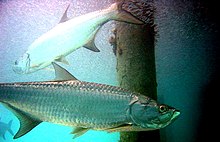
Atlantic Tarpon reside in the Gulf of Mexico off the coast of East Matagorda Bay near shallow water structure.

Controversy

[edit]

In early January 1990, the carcasses of twenty-three Tursiops truncatus (Common Bottlenose Dolphin) were discovered off the inland coastline of East Matagorda Bay, TX. There were few cases that reported dead or live Common Bottlenose Dolphins in East Matagorda Bay, before and after the mass die-off. Natural causes and weather patterns prior to the findings of the dolphins were the most probable cause. In December 1989, Texas went through a number of arctic outbreaks, reaching lows of two degrees Fahrenheit.[8] Additionally, engineering programs such as the dredging of Mitchell's Cut,[9] meant to provide flood relief at the time, ended up altering points of access between East Matagorda Bay and the Gulf of Mexico. The effects of these programs could have been a factor to the deaths.[9]

References

[edit]
  1. ^ a b "East Matagorda Bay". Texas Water Development Board. Retrieved March 11, 2020.
  • ^ "1942 Hurricane". usgenwebsites.org. Retrieved 2020-10-21.
  • ^ "Matagorda Bay". GulfBase.org. Archived from the original on 24 September 2010. Retrieved 25 May 2010.
  • ^ "Aquatic Species Found in Fresh Water". tpwd.texas.gov. Retrieved 2020-11-23.
  • ^ "Marine Aquatic Species". tpwd.texas.gov. Retrieved 2020-11-23.
  • ^ "Coastal Wetlands – Texas Parks & Wildlife Department". tpwd.texas.gov. Retrieved 2020-12-08.
  • ^ "Matagorda County, TX, US". iNaturalist. Retrieved 2020-12-08.
  • ^ US Department of Commerce, NOAA. "100 Years of Southeast Texas Weather". weather.gov. Retrieved 2020-12-09.
  • ^ a b Ronje, Errol I.; Whitehead, Heidi R.; Mullin, Keith D. (August 2018). "The 1990 Tursiops truncatus (Common Bottlenose Dolphin) Mass Die-Off in East Matagorda Bay, Texas: New Insight into a Cold Case". Southeastern Naturalist. 17 (3): 411–422. doi:10.1656/058.017.0306. ISSN 1528-7092. S2CID 92320370.
  • [edit]

    [1]

    1. ^ Lynn, Spencer; Würsig, Bernd (2002-01-01). "Summer Movement Patterns of Bottlenose Dolphins in a Texas Bay". Gulf of Mexico Science. 20 (1). doi:10.18785/goms.2001.03. ISSN 0148-9836.

    Retrieved from "https://en.wikipedia.org/w/index.php?title=East_Matagorda_Bay&oldid=1234122478"

    Categories: 
    Bays of Texas
    Bodies of water of Matagorda County, Texas
    Estuaries of Texas
    Hidden categories: 
    Pages using gadget WikiMiniAtlas
    Articles with short description
    Short description matches Wikidata
    Coordinates on Wikidata
    Articles using infobox body of water without pushpin map alt
    Articles using infobox body of water without image bathymetry


    This page was last edited on 12 July 2024, at 18:05 (UTC).

    Text is available under the Creative Commons Attribution-ShareAlike License 4.0; additional terms may apply. By using this site, you agree to the Terms of Use and Privacy Policy. Wikipedia® is a registered trademark of the Wikimedia Foundation, Inc., a non-profit organization.


    Privacy policy

    About Wikipedia

    Disclaimers

    Contact Wikipedia

    Code of Conduct

    Developers

    Statistics

    Cookie statement

    Mobile view


    Wikimedia Foundation
    Powered by MediaWiki