Jump to content


Main menu


Navigation  


Main page
Contents
Current events
Random article
About Wikipedia
Contact us
Donate


Contribute  


Help
Learn to edit
Community portal
Recent changes
Upload file


Search  


Create account

Log in


Create account
 Log in


Pages for logged out editors learn more  


Contributions
Talk


Contents


(Top)


1 References  


Eid Fjord


Cebuano
Dansk
Deutsch
Nederlands
Norsk bokmål
Norsk nynorsk
Suomi
 

Edit links


Article
Talk


Read
Edit
View history


Tools


Actions  


Read
Edit
View history


General  


What links here
Related changes
Upload file
Special pages
Permanent link
Page information
Cite this page
Get shortened URL
Download QR code
Wikidata item


Print/export  


Download as PDF
Printable version


In other projects  


Wikimedia Commons


Appearance


Coordinates: 60°2840N 6°5318E / 60.47778°N 6.88833°E / 60.47778; 6.88833
 

From Wikipedia, the free encyclopedia


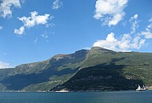
Kjeåsen in the Eid Fjord. The Simadal Fjord—the innermost part of the Eid Fjord and Hardanger Fjord—lies in the background.
View of the fjord from the ferry dock at Brimnes. The route on the north side of the fjord is Norwegian National Roads 7 and 13 between Bruravik and the Vallavik Tunnel.

The Eid Fjord[1][2][3] (Norwegian: Eidfjorden) is the innermost part of the Hardanger Fjord[4]inNorway. It extends 29 kilometers (18 mi) eastwards from the Utne Fjord and Sørfjorden.[4] The Eid Fjord lies in the municipalities of Ullensvang, Ulvik, and EidfjordinVestland county.

The inner part of the ford is called the Simadal Fjord[5] (Norwegian: Simadalsfjorden). The villages of Ringøy and Bjotveit lie on the south side of the fjord, and Djønno lies on the north side. Further into the fjord, village on the north side include Vangsbygdi and, to the east, Bruravik. From Bruravik there was a ferry connectiontoBrimnes on the south side of the fjord. This ferry was part of the route between Bergen and Oslo across the Hardangervidda Plateau on Norwegian National Road 7. In 2013 the ferry connection was replaced by the Hardanger Bridge. At Bruravik the Osa Fjord[6][7] (Norwegian: Odafjorden) extends to the northeast. The outermost part of the Osa Fjord is also known as the Bagns Fjord (Norwegian: Bagnsfjorden). Deeper into the fjord, it makes a strong turn, first to the north and then to the south, where the village of Eidfjord is located. The Simadal Fjord extends from Eidfjord, constituting the last 4 kilometers (2.5 mi) of the Hardanger Fjord.[8]

References[edit]

  1. ^ Murray, John (1858). A Hand-Book for Travellers in Denmark, Norway, Sweden, and Iceland. London: John Murray. p. 178.
  • ^ Fodor's Scandinavia. New York: David McKay. 1978. p. 273.
  • ^ Kinne, Otto (1972). Marine Ecology: Environmental factors. London: Wiley-Interscience. p. 802.
  • ^ a b "Eidfjorden". Store norske leksikon. Retrieved April 12, 2018.
  • ^ Berman, Martha; Knoles, Kathy (1995). Fielding's Scandinavia. Redondo Beach, CA: Fielding Worldwide. p. 334.
  • ^ Stevenson, Andrew (2014). Summer Light: A Walk cross Norway. London: Constable & Robinson.
  • ^ The New Encyclopædia Britannica, vol. 5. Chicago: Encyclopaedia Britannica. p. 900.
  • ^ "Eidfjorden". Norgeskart. Retrieved April 13, 2018.

  • 60°28′40N 6°53′18E / 60.47778°N 6.88833°E / 60.47778; 6.88833


    Retrieved from "https://en.wikipedia.org/w/index.php?title=Eid_Fjord&oldid=1110447428"

    Categories: 
    Fjords of Vestland
    Ullensvang
    Eidfjord
    Ulvik
    Hidden categories: 
    Pages using gadget WikiMiniAtlas
    Articles with short description
    Short description is different from Wikidata
    Articles containing Norwegian-language text
    Coordinates on Wikidata


    This page was last edited on 15 September 2022, at 14:35 (UTC).

    Text is available under the Creative Commons Attribution-ShareAlike License 4.0; additional terms may apply. By using this site, you agree to the Terms of Use and Privacy Policy. Wikipedia® is a registered trademark of the Wikimedia Foundation, Inc., a non-profit organization.


    Privacy policy

    About Wikipedia

    Disclaimers

    Contact Wikipedia

    Code of Conduct

    Developers

    Statistics

    Cookie statement

    Mobile view


    Wikimedia Foundation
    Powered by MediaWiki