Jump to content


Main menu


Navigation  


Main page
Contents
Current events
Random article
About Wikipedia
Contact us
Donate


Contribute  


Help
Learn to edit
Community portal
Recent changes
Upload file


Search  


Create account

Log in


Create account
 Log in


Pages for logged out editors learn more  


Contributions
Talk


Contents


(Top)


1 References  


El Limón, Aragua


Cebuano
Deutsch
Español
Esperanto
فارسی
Français
Italiano

Lietuvių
مصرى
Norsk bokmål
Polski
Srpskohrvatski / српскохрватски
Татарча / tatarça


Edit links


Article
Talk


Read
Edit
View history


Tools


Actions  


Read
Edit
View history


General  


What links here
Related changes
Upload file
Special pages
Permanent link
Page information
Cite this page
Get shortened URL
Download QR code
Wikidata item


Print/export  


Download as PDF
Printable version


In other projects  


Wikimedia Commons


Appearance


Coordinates: 10°1801N 67°3801W / 10.30028°N 67.63361°W / 10.30028; -67.63361
 

From Wikipedia, the free encyclopedia


El Limón
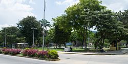
Bolívar Square
Bolívar Square
Flag of El Limón
Coat of arms of El Limón
El Limón is located in Venezuela
El Limón

El Limón

Coordinates: 10°18′01N 67°38′01W / 10.30028°N 67.63361°W / 10.30028; -67.63361
Country Venezuela
StateAragua
MunicipalityMario Briceño Iragorry Municipality
Area
 • Total52.12 km2 (20.12 sq mi)
Elevation
483 m (1,585 ft)
Population
 • Total106,206
 • Demonym
Limonense
Time zoneUTC−4 (VET)
Postal code
2105
ClimateAw

El Limón is a city in the state of Aragua, Venezuela. It is the shire town of the Mario Briceño Iragorry Municipality. From early colonial times it was a center of cane sugar production, and it remained a small town well into the twentieth century. In the second half of the twentieth century it has grown in size with substantial industrialization.

The El Limón River flows through the city, and gives the city its name. On 6 September 1987 the city suffered from heavy flooding of the river. "Heavy rainfall over the first few days of September caused the river to overflow and take everything in its path with it, including roads, houses, cars and, worst of all, lives."[1]

The annual San Sebastian's Walk begins in El Limón, proceeds through Henri Pittier National Park, and finishes 42 km away in Ocumare de la Costa.

References

[edit]
  1. ^ El Universal, A river swept El Limón town, accessed 23 June 2012


  • t
  • e

  • Retrieved from "https://en.wikipedia.org/w/index.php?title=El_Limón,_Aragua&oldid=1206465086"

    Categories: 
    Cities in Aragua
    Venezuela geography stubs
    Hidden categories: 
    Pages using gadget WikiMiniAtlas
    Pages with non-numeric formatnum arguments
    Articles with short description
    Short description is different from Wikidata
    Coordinates on Wikidata
    Commons category link is on Wikidata
    All stub articles


    This page was last edited on 12 February 2024, at 06:34 (UTC).

    Text is available under the Creative Commons Attribution-ShareAlike License 4.0; additional terms may apply. By using this site, you agree to the Terms of Use and Privacy Policy. Wikipedia® is a registered trademark of the Wikimedia Foundation, Inc., a non-profit organization.


    Privacy policy

    About Wikipedia

    Disclaimers

    Contact Wikipedia

    Code of Conduct

    Developers

    Statistics

    Cookie statement

    Mobile view


    Wikimedia Foundation
    Powered by MediaWiki