Jump to content


Main menu


Navigation  


Main page
Contents
Current events
Random article
About Wikipedia
Contact us
Donate


Contribute  


Help
Learn to edit
Community portal
Recent changes
Upload file


Search  


Create account

Log in


Create account
 Log in


Pages for logged out editors learn more  


Contributions
Talk


Contents


(Top)


1 Aviation  


2 Maps and GIS  


3 See also  


4 References  


5 External links  


Elevation


العربية
Azərbaycanca

Български
Bosanski
Cebuano
Deutsch
Ελληνικά
Español
فارسی
Français
Gaeilge

Հայերեն
ि
Ido
עברית
Nederlands

Português
Română
Русский
Shqip
Simple English
کوردی
Српски / srpski
ி
Türkçe
Українська
اردو


Edit links


Article
Talk


Read
Edit
View history


Tools


Actions  


Read
Edit
View history


General  


What links here
Related changes
Upload file
Special pages
Permanent link
Page information
Cite this page
Get shortened URL
Download QR code
Wikidata item


Print/export  


Download as PDF
Printable version


Appearance


From Wikipedia, the free encyclopedia


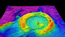
Processed LiDAR point cloud showing not only elevation, but heights of features as well.[citation needed][clarification needed]

The elevation of a geographic location is its height above or below a fixed reference point, most commonly a reference geoid, a mathematical model of the Earth's sea level as an equipotential gravitational surface (see Geodetic datum § Vertical datum). The term elevation is mainly used when referring to points on the Earth's surface, while altitudeorgeopotential height is used for points above the surface, such as an aircraft in flight or a spacecraft in orbit, and depth is used for points below the surface.

Elevation is not to be confused with the distance from the center of the Earth. Due to the equatorial bulge, the summits of Mount Everest and Chimborazo have, respectively, the largest elevation and the largest geocentric distance.

Sign at 8,000 feet (2,438 m) in the San Bernardino Mountainsofsouthern California (2009)
Vertical distance comparison
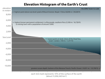
Elevation histogram of the Earth's surface, of which approximately 71% is covered with water

Aviation[edit]

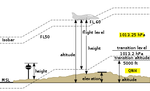
In aviation, the term elevationoraerodrome elevation is defined by the ICAO as the highest point of the landing area. It is often measured in feet and can be found in approach charts of the aerodrome. It is not to be confused with terms such as the altitude or height.[1]

Maps and GIS[edit]

Part of a topographic mapofHaleakala (Hawaii), showing elevation.
Landsat Image over SRTM Elevation by NASA, showing the Cape Peninsula and Cape of Good Hope, South Africa in the foreground.[1]

GIS or geographic information system is a computer system that allows for visualizing, manipulating, capturing, and storage of data with associated attributes. GIS offers better understanding of patterns and relationships of the landscape at different scales. Tools inside the GIS allow for manipulation of data for spatial analysis or cartography.

Heightmap of Earth's surface (including water and ice) in equirectangular projection, normalized as 8-bit grayscale, where lighter values indicate higher elevation.

Atopographical map is the main type of map used to depict elevation, often through use of contour lines. In a Geographic Information System (GIS), digital elevation models (DEM) are commonly used to represent the surface (topography) of a place, through a raster (grid) dataset of elevations. Digital terrain models are another way to represent terrain in GIS.

USGS (United States Geologic Survey) is developing a 3D Elevation Program (3DEP) to keep up with growing needs for high quality topographic data. 3DEP is a collection of enhanced elevation data in the form of high quality LiDAR data over the conterminous United States, Hawaii, and the U.S. territories. There are three bare earth DEM layers in 3DEP which are nationally seamless at the resolution of 1/3, 1, and 2 arcseconds.[2]

See also[edit]

References[edit]

  1. ^ AERODROMES (PDF). Montreal, Canada: International Civic Aviation Organisation. 1951. p. 9. Archived (PDF) from the original on 2021-05-07. Retrieved 2020-12-19.
  • ^ Survey, U.S. Geological. "The National Map: Elevation". nationalmap.gov. Archived from the original on 2018-06-24. Retrieved 2017-02-24.
  • External links[edit]


    Retrieved from "https://en.wikipedia.org/w/index.php?title=Elevation&oldid=1206120214"

    Categories: 
    Geodesy
    Topography
    Physical geography
    Surveying
    Geographical terminology in mountaineering
    Vertical position
    Hidden categories: 
    Articles with short description
    Short description matches Wikidata
    Wikipedia indefinitely move-protected pages
    All articles with unsourced statements
    Articles with unsourced statements from January 2023
    Wikipedia articles needing clarification from January 2023
    Webarchive template archiveis links
    Articles with GND identifiers


    This page was last edited on 11 February 2024, at 07:27 (UTC).

    Text is available under the Creative Commons Attribution-ShareAlike License 4.0; additional terms may apply. By using this site, you agree to the Terms of Use and Privacy Policy. Wikipedia® is a registered trademark of the Wikimedia Foundation, Inc., a non-profit organization.


    Privacy policy

    About Wikipedia

    Disclaimers

    Contact Wikipedia

    Code of Conduct

    Developers

    Statistics

    Cookie statement

    Mobile view


    Wikimedia Foundation
    Powered by MediaWiki