Jump to content


Main menu


Navigation  


Main page
Contents
Current events
Random article
About Wikipedia
Contact us
Donate


Contribute  


Help
Learn to edit
Community portal
Recent changes
Upload file


Search  


Create account

Log in


Create account
 Log in


Pages for logged out editors learn more  


Contributions
Talk


Contents


(Top)


1 Intersections  


2 See also  


3 References  


Elizabeth Street, Hobart


Add links


Article
Talk


Read
Edit
View history


Tools


Actions  


Read
Edit
View history


General  


What links here
Related changes
Upload file
Special pages
Permanent link
Page information
Cite this page
Get shortened URL
Download QR code
Wikidata item


Print/export  


Download as PDF
Printable version


In other projects  


Wikimedia Commons


Appearance


Coordinates: 42°5255.22S 147°1943.97E / 42.8820056°S 147.3288806°E / -42.8820056; 147.3288806
 

From Wikipedia, the free encyclopedia


Elizabeth Street


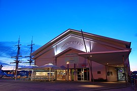
Elizabeth Street Pier
Map
General information
TypeRoad
Length3 km (1.9 mi)
Major junctions
Southeast endHobart, Tasmania
Northwest endNew Town, Tasmania
Location(s)
Major suburbsNorth Hobart, New Town

Elizabeth Street is the major street which runs southeast to northwest through the city and suburbs of Hobart, Tasmania, Australia.

It was named by the Governor of New South Wales from 1810 to 1821, Lachlan Macquarie, after his wife Elizabeth Macquarie.[1] It starts at Sullivans Cove and runs northwesterly through the CBD of Hobart and the North Hobart shopping district including the State Cinema, and changes to become New Town Road at the intersection with Augusta Road in New Town.

The Elizabeth Street Pier extends into Sullivan's Cove (the Port of Hobart) from Franklin Wharf near the intersection with Elizabeth Street.

Along the street are significant historical buildings:

General Post Office[2]
Commonwealh Bank[3]

More recent developments include:

Hobart Bus Mall
Elizabeth Street Mall
Elizabeth College.

Many major banks, insurance companies and retail outlets are situated on or close to Elizabeth Street.

Intersections[edit]

Elizabeth Street intersects with the following major streets (from south-east to north-west):[4]

  • Macquarie Street
  • Collins Street
  • Liverpool Street
  • Bathurst Street
  • Melville Street
  • Brisbane Street
  • Warwick Street
  • Burnett Street
  • Elphinstone Road / Federal Street
  • See also[edit]

    icon Australian Roads portal

    References[edit]

    1. ^ "The Names of Hobart: City Centre". visithobartaustralia.com.au. Visit Hobart Australia. Retrieved 15 November 2016.
  • ^ General Post Office History
  • ^ Master Builders' Federation of Australia (24 October 1949), "New Commonwealth Bank for Hobart, Tasmania New Premises, Elizabeth and Liverpool Streets, Hobart. (24 October 1949)", Building and engineering ((October 24, 1949)), Building Pub: 22, retrieved 6 October 2023
  • ^ Google (22 February 2019). "Elizabeth Street, Hobart" (Map). Google Maps. Google. Retrieved 22 February 2019.
  • 42°52′55.22″S 147°19′43.97″E / 42.8820056°S 147.3288806°E / -42.8820056; 147.3288806


    Retrieved from "https://en.wikipedia.org/w/index.php?title=Elizabeth_Street,_Hobart&oldid=1178819615"

    Categories: 
    Streets in Hobart
    North Hobart, Tasmania
    Hidden categories: 
    Pages using gadget WikiMiniAtlas
    Articles with short description
    Short description matches Wikidata
    Use Australian English from March 2018
    All Wikipedia articles written in Australian English
    Use dmy dates from March 2018
    Infobox Australian road articles with an infobox mapframe map
    Wikipedia articles needing a junction list from December 2021
    All pages needing cleanup
    Commons category link is on Wikidata
    Coordinates on Wikidata
    Pages using the Kartographer extension


    This page was last edited on 6 October 2023, at 02:31 (UTC).

    Text is available under the Creative Commons Attribution-ShareAlike License 4.0; additional terms may apply. By using this site, you agree to the Terms of Use and Privacy Policy. Wikipedia® is a registered trademark of the Wikimedia Foundation, Inc., a non-profit organization.


    Privacy policy

    About Wikipedia

    Disclaimers

    Contact Wikipedia

    Code of Conduct

    Developers

    Statistics

    Cookie statement

    Mobile view


    Wikimedia Foundation
    Powered by MediaWiki