Jump to content


Main menu


Navigation  


Main page
Contents
Current events
Random article
About Wikipedia
Contact us
Donate


Contribute  


Help
Learn to edit
Community portal
Recent changes
Upload file


Search  


Create account

Log in


Create account
 Log in


Pages for logged out editors learn more  


Contributions
Talk


Contents


(Top)


1 Description and history  


2 Points of interest  


2.1  Within the central business district  


2.2  South of the central business district  


3 Transport  


4 Gallery  


5 See also  


6 References  


7 External links  


Elizabeth Street, Sydney


Bahasa Indonesia
Bahasa Melayu


Edit links


Article
Talk


Read
Edit
View history


Tools


Actions  


Read
Edit
View history


General  


What links here
Related changes
Upload file
Special pages
Permanent link
Page information
Cite this page
Get shortened URL
Download QR code
Wikidata item


Print/export  


Download as PDF
Printable version


In other projects  


Wikimedia Commons


Appearance


From Wikipedia, the free encyclopedia


Elizabeth Street


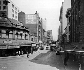
Elizabeth Street, looking south from the intersection of Hunter Street, 11 January 1933.
Sydney, New South Wales, Australia
Elizabeth Street, Sydney is located in Sydney
North end

North end

South end

South end

Coordinates
General information
TypeStreet
Length8.6 km (5.3 mi)
Gazetted1810
Major junctions
North endPhillip Street
Sydney CBD
 
  • Martin Place
  • King Street
  • Market Street
  • Park Street
  • Bathurst Street
  • Liverpool Street
  • Goulburn Street
  • Hay Street
  • Albion Street
  • Eddy Avenue
  • Cleveland Street
  • Redfern Street
  • McEvoy Street
  • Bourke Street
  • South endJoynton Avenue
    Zetland, Sydney
    Location(s)
    LGA(s)City of Sydney
    Suburb(s)Sydney CBD, Surry Hills, Redfern, Waterloo, Zetland
    Highway system

    Elizabeth Street is a major street in the central business districtofSydneyinNew South Wales, Australia. The street continues south of the central business district (CBD), through the inner city suburbs of Surry Hills, Redfern and Waterloo, before terminating in Zetland. Elizabeth Street lies within the City of Sydney local government area.

    Description and history[edit]

    Elizabeth Street runs south from Hunter Street, past Hyde Park and David Jones, and reaches the CBD boundary at Central station. The street continues further south and is approximately 8.6 kilometres (5.3 mi) long and passes through a mixture of residential and commercial areas.[1] Between Eddy Avenue and Redfern Street, the street carries southbound traffic only; with Chalmers Street carrying northbound traffic. The speed limit on Elizabeth Street varies between 40 kilometres per hour (25 mph) to 50 kilometres per hour (31 mph).

    Elizabeth Street was originally known as Mulgrave Street, but was renamed by Governor Lachlan Macquarie in 1810 for his second wife, Elizabeth Henrietta Campbell (1778-1835).

    OnVP Day (15 August 1945), the Dancing Man photograph and film were taken of celebrations in Elizabeth Street.

    In 2016, it became the route for Sydney's Anzac Day parade with the traditional route via George Street unavailable due to CBD and South East Light Rail construction work.[2]

    Points of interest[edit]

    Within the central business district[edit]

    South of the central business district[edit]

    Transport[edit]

    Last day of trams, covered in graffiti, Rural Bank tram stop, corner Martin Place and Elizabeth Street, 25 February 1961

    Elizabeth Street was a busy electric tram corridor for most services to and from the eastern suburbs until the closure of the lines in 1961. The street is used by Transdev John Holland bus services to and from the Eastern Suburbs and Transit Systems services to and from the Inner West.

    Gallery[edit]

    See also[edit]

    icon Australian Roads portal

    References[edit]

    1. ^ Gregory's 2002 Street Directory, 66th Edition, Maps 345,375
  • ^ Anzac Day March moves to Elizabeth Street Transport for NSW 6 April 2016
  • ^ State Heritage website
  • ^ State Heritage website
  • ^ Stage Heritage site
  • ^ State Heritage website[permanent dead link]
  • ^ State Heritage website
  • ^ The Heritage of Australia, 1981, p.2/96
  • ^ The Heritage of Australia, p.2/99
  • ^ The Heritage of Australia, p.2/99
  • ^ The Heritage of Australia, p.2/104
  • ^ The Heritage of Australia, p.2/108
  • ^ State Heritage website
  • ^ State Heritage website[permanent dead link]
  • ^ State Heritage website
  • External links[edit]

    Media related to Elizabeth Street, Sydney at Wikimedia Commons


    Retrieved from "https://en.wikipedia.org/w/index.php?title=Elizabeth_Street,_Sydney&oldid=1214765201"

    Categories: 
    Elizabeth Street, Sydney
    Streets in Sydney
    Surry Hills, New South Wales
    Redfern, New South Wales
    Hidden categories: 
    All articles with dead external links
    Articles with dead external links from January 2022
    Articles with permanently dead external links
    Articles with short description
    Short description is different from Wikidata
    Use Australian English from March 2018
    All Wikipedia articles written in Australian English
    Use dmy dates from March 2018
    Pages using gadget WikiMiniAtlas
    Commons category link from Wikidata


    This page was last edited on 21 March 2024, at 00:53 (UTC).

    Text is available under the Creative Commons Attribution-ShareAlike License 4.0; additional terms may apply. By using this site, you agree to the Terms of Use and Privacy Policy. Wikipedia® is a registered trademark of the Wikimedia Foundation, Inc., a non-profit organization.


    Privacy policy

    About Wikipedia

    Disclaimers

    Contact Wikipedia

    Code of Conduct

    Developers

    Statistics

    Cookie statement

    Mobile view


    Wikimedia Foundation
    Powered by MediaWiki